All Activity
- Past hour
-

May 2024 Discussion - Welcome to Severe Season!!!!
Damage In Tolland replied to weatherwiz's topic in New England
Now they slowly , sneakily admit to their bust of having a dry forecast 1015 AM Update: Not much change from previous forecast, cloudy with periods of light rain and drizzle. Not a washout, but more nuisance rain. Currently some enhancement to the rainfall taking place across the Worcester Hills. This is in response to NE flow up to 19 kt at KORH, providing upslope component. Otherwise, it`s periods of light rain/drizzle. Rain shield struggling to reach western MA/CT, as low level jet weakens westward. In fact, across this region there are some breaks in the overcast and dry weather yielding temps in the low 60s. Meanwhile, the remainder of the region is stuck in the 50s. Normal high for May 18th is 67-72. Thus, much cooler than normal especially across eastern MA and RI. Previous discussion below. --------------------- -
May 2024 Discussion - Welcome to Severe Season!!!!
Damage In Tolland replied to weatherwiz's topic in New England
At least our Sunday will be nice while out east stays cloudy and cool . I’ll take solace in that and look forward to returning the posting favors tomorrow -

May 2024 Discussion - Welcome to Severe Season!!!!
CoastalWx replied to weatherwiz's topic in New England
Gee I’m glad we aren’t EMATT they said. Gonna be a nasty Saturday they said. -

May 2024 Discussion - Welcome to Severe Season!!!!
kdxken replied to weatherwiz's topic in New England
Dry here too. Hopefully it is for everyone! -
May 2024 Discussion - Welcome to Severe Season!!!!
CoastalWx replied to weatherwiz's topic in New England
What a nice dry day to do some yardwork. I wonder what others are doing today. -
Expected more lake cooling today, feels hot out already Beach season with an early start
-
May 2024 Discussion - Welcome to Severe Season!!!!
Damage In Tolland replied to weatherwiz's topic in New England
What I meant though .. was it seemed like a shower here and there. Nothing.. nothing had an all day deform zone rotting over a narrow area . I’m already at .30. Show me a model that had these 1” amounts up thru 18z yesterday that we’re going to get -

May 2024 Discussion - Welcome to Severe Season!!!!
WxWatcher007 replied to weatherwiz's topic in New England
Presenting without comment. https://x.com/nwsboston/status/1791737962193142107?s=46&t=Nn9Cx92_8118fPdhHPdJHw -
-

May 2024 Discussion - Welcome to Severe Season!!!!
Typhoon Tip replied to weatherwiz's topic in New England
Well ...anyway, back here in reality ... That's starting to look more and more like a low-grade heat wave potential Tue-Wed-Thur. The 2-m products ( which are a joke, because they don't in fact actually ever represent the 2-meter slope temperature, but appear to stop/interpret the sfc as the 1000 mb level on the bottom of the soundings ) from the operational runs are already 85 to 87 on Tuesday and Wednesday... 850s are marginal though. 14 to 16C ... but that appears to coincide with favorably less ceiling/blocked insolation, all happening over a wind trajectory that is transporting a kinetically elevated air mass. This has been sort of in the making for over a week in the telecon spreads, with a pretty strong -PNA. It seems to be finally over powering this weird trainwreck thing we've been observing for the past week between here and lower D. Straight. The NAO hasn't been hugely negative ...just sort of. It seems some other emergence of the larger scoped synoptics is/has caused this semi-permanent grunge stalling in in the area... Anyway, 88 to 91 wouldn't shock me for those two days with Thursday a bit sketchy because a Pac front/convection my break the party at that time. And the upshot of this analysis is that I actually studied the guidance when drafting these projections ... -
May 2024 Discussion - Welcome to Severe Season!!!!
Typhoon Tip replied to weatherwiz's topic in New England
WTF ... I just bold' right back to you, what you posted about NWS SO yeah, I did - 'showers are possible at any time' you seem to also be blind to content that proves, in objective clad black and white facts, your BS - I forgot to add that charm to that list of your accolades - -
May 2024 Discussion - Welcome to Severe Season!!!!
CoastalWx replied to weatherwiz's topic in New England
Actually wouldn’t mind a little rain because stein is here for awhile. -
1.44" of rain last night. The most from any single event since January 27 when 1.47" fell !!
-
May 2024 Discussion - Welcome to Severe Season!!!!
Typhoon Tip replied to weatherwiz's topic in New England
Ha ha ha to say nothing of the fact that Dendrite only must somehow be construed as a positive thing when it comes to turd weather - -
May 2024 Discussion - Welcome to Severe Season!!!!
CoastalWx replied to weatherwiz's topic in New England
We stein here. Dry day. -

May 2024 Discussion - Welcome to Severe Season!!!!
powderfreak replied to weatherwiz's topic in New England
See I think in the winter you would’ve taken the over and more snowy in this set-up with onshore flow. Would’ve been back to NY state with precip. But Murphy’s law says it wouldn’t have worked out in the winter, just as a mocking from Mother Nature. 3km NAM figured it out now.
- Today
-
we are in that narrow sliver of sun here. 66 degrees...raining in E CT
-
May 2024 Discussion - Welcome to Severe Season!!!!
powderfreak replied to weatherwiz's topic in New England
I thought yesterday the rain looked to back decently west too on a lot of models I wasn’t sure where the east only or Dendrite only was coming from except for “positive thinking” like you said. Its onshore flow and wedged, easy to see it being chilly and damp. 12z Euro run yesterday looked regionwide showery. GGEM rotating stuff inward.
-
69 and mostly cloudy. Rain staying south so far. Mostly cloudy today and part of tomorrow before clearing. Overall much warmer week ahead with Tue (5/21) - Thu (5/23) warmest of the next 7 days. Shot at mid 80s to low 90s in the hot spots. Fri (5/24) into next weekend / Memorial Day weekend, looking near normal - slightly above - and mainly dry at this range GFS / and a bit wet on the euro Sat-sun. Will see. Beyond there overall near normal to close the month as it looks today.
-
May 2024 Discussion - Welcome to Severe Season!!!!
Damage In Tolland replied to weatherwiz's topic in New England
What looked like maybe a scattered shower on models yesterday has turned into an all day soaking rain of .50-1”. It’s literally just unbelievable how bad modeling was -

May 2024 Discussion - Welcome to Severe Season!!!!
ma blizzard replied to weatherwiz's topic in New England
great day for an outdoor wedding in SE NH ... meanwhile its starting to pour in metro west -
Was summer-like when I left Albany yesterday afternoon and Seattle-like when I arrived in NYC three hours later. Make it stop!
-
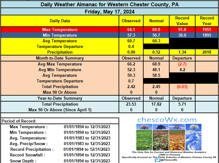
Today looks to be our last chilly and dreary day with temps struggling to no higher than the mid 60's. The sun returns tomorrow. Our next chance of rain after today looks to be Wednesday night. Some lower spots could approach 80 degrees on Wednesday before we fall back to near normal temps around the mid 70's toward the Memorial Day Weekend! Chester County wide records for today: High 95 degrees on this date back in 1962 at Devault 1W, Coatesville 1SW and Phoenixville/ Record low occurred just last year with a 29.4 degree temperature in Warwick Township (2023) / Rain 2.68" at Marshallton (2015)
-

E PA/NJ/DE Spring 2024 OBS/Discussion
ChescoWx replied to Hurricane Agnes's topic in Philadelphia Region
Today looks to be our last chilly and dreary day with temps struggling to no higher than the mid 60's. The sun returns tomorrow. Our next chance of rain after today looks to be Wednesday night. Some lower spots could approach 80 degrees on Wednesday before we fall back to near normal temps around the mid 70's toward the Memorial Day Weekend! Chester County wide records for today: High 95 degrees on this date back in 1962 at Devault 1W, Coatesville 1SW and Phoenixville/ Record low occurred just last year with a 29.4 degree temperature in Warwick Township (2023) / Rain 2.68" at Marshallton (2015)
-
May 2024 Discussion - Welcome to Severe Season!!!!
CoastalWx replied to weatherwiz's topic in New England
Looks almost deffy like. Good WAA with 850 theta-e