All Activity
- Past hour
-
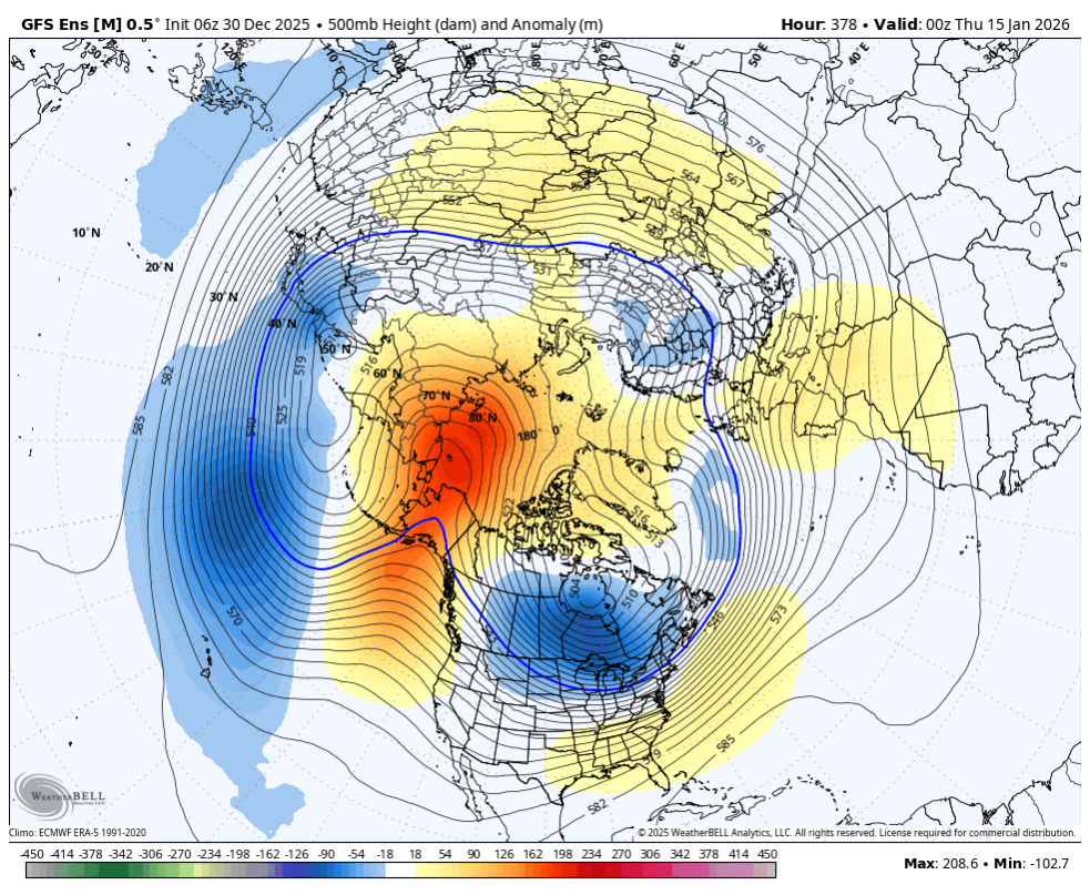
Looks like 4th and 7, need to punt. Maybe the offense can matriculate down the field a bit more once we establish a solid - EPO in about 10-12 days.
-
Yeah if we get a major EPO ridge as advertised, we want a flat SE ridge to keep the storm track nearby.
-

New Years Day 2026 - 1st snows of the new year possible
TauntonBlizzard2013 replied to Baroclinic Zone's topic in New England
Could definitely produce a few inches south of Boston if things break right -

January 2026 regional war/obs/disco thread
40/70 Benchmark replied to Baroclinic Zone's topic in New England
The atmosphere conserves energy for Maritime lows and cutters.....notice the Michigan bomb had no problem detonating....but then when something is near the east coast, the gradient and Hadley Cell are of a sudden prohibitive. -
January 2026 regional war/obs/disco thread
TauntonBlizzard2013 replied to Baroclinic Zone's topic in New England
Yeah, at some point, we’d expect to congeal some sort of coherent signal, and that’s just not happening. -

January 2026 regional war/obs/disco thread
Sey-Mour Snow replied to Baroclinic Zone's topic in New England
Step back at 00z hopefully we revert back positively for 12z -
January 2026 regional war/obs/disco thread
40/70 Benchmark replied to Baroclinic Zone's topic in New England
I know Kev loves his 2"ers...but at that cost? Rather see the ball drop on cracked, barren earth with my eyes peeled to explosive model runs. -
My concern with the 8-10th period has been and will continue to be the lack of solutions showing storms. The means regressed significantly last night and even those had been driven by a couple members with a big storm vs a lot of members showing something or something close. It just hasn’t gathered much modeling support and in the 10-day timeframe you’d really want to at least start seeing ensemble support for a valid threat
-
January 2026 regional war/obs/disco thread
TauntonBlizzard2013 replied to Baroclinic Zone's topic in New England
I mentioned that yesterday. Looks like it could be a small event for se Mass and cape. I was more talking longer term potential. Definitely nothing imminent -
Now THIS reminds me of years of my youth. It snow flurried here for hours yesterday evening and overnight, I have MAYBE 0.5" of snow blown against objects and in low spots, not a complete cover. But, JUST to my west there is a solid 1" or more and it is still coming down. Looking at cameras, yep, 'Shoe, Homestead up in Hot Springs, up in Highland county, over to Lewisburg WV all look to have 1-2 OTG at the least. Currently partly cloudy, 18.8/9.3 with W wind 12 gusting to 26 mph. Highest wind I had was 51 mph at 12:47 am. Edit-story time. Reason this SO reminds me is this would happen and we'd get a 2 hour delay or sometimes even at cancel for school. Mom was a RR carrier for post office, so I'd be delegated to helping deliver (putting mail in the box from passenger seat as she drove) on her route on cancel days. She did the western and southern part of the county. No sooner than we'd leave the city of Covington snow would go from what I have today to complete cover and deeper the further we'd go west. Up near the WV line there'd be 2 or 3 inches, same for the southern areas near Craig county line. Get back home and as 'ol Yukon Cornelius would say... nuthin.
-
Dude you are horrible. You have had a bad December. Dont worry the warmth will eventually be here. Now here is the 6z gefs run. Back to cold.

-
January 2026 regional war/obs/disco thread
40/70 Benchmark replied to Baroclinic Zone's topic in New England
If I had my druthers, I would eradicate that clipper....it offers much more risk than reward- -
Fab Feb your table is ready
-
January 2026 regional war/obs/disco thread
40/70 Benchmark replied to Baroclinic Zone's topic in New England
Looping through the EPS, it kind of seems to me that the clipper blows up once past our longitude (of course) and nails the Maritimes, only to push the main baroclinic zone far enough out so that any potential follow up joy suffers a similar fate. -
It could be right but we had one bad suite. For now it’s a blip not a trend.
-

Pittsburgh/Western PA WINTER ‘25/‘26
Burghblizz replied to Burghblizz's topic in Upstate New York/Pennsylvania
Avella, Wash county near Ohio border - 7”. Someone might pop 10” down there! Not sure we have any posters in the middle of that, but figure some of the south hills posters will have a decent amount. Unreal - we do all this “work” sometimes to bring home big snows. Then every once in awhile this happens. (Sadly, I’m sitting under 2” for this, but hoping something better oscillates in) -
Reports of the clippers’ death are greatly exaggerated .
-
January 2026 regional war/obs/disco thread
40/70 Benchmark replied to Baroclinic Zone's topic in New England
I haven't seen the level of commitment I would like at this juncture to be excited...we still seem to be in the "pattern phase", which elicits some type of hope and optimism that has yet to be focused. Frankly, I have had enough of that over the course of the past 8 years because it's seldom ended well. -

Central PA Winter 25/26 Discussion and Obs
mahantango#1 replied to MAG5035's topic in Upstate New York/Pennsylvania
I'm so over this wind. -
.
-

New Years Day 2026 - 1st snows of the new year possible
Go Kart Mozart replied to Baroclinic Zone's topic in New England
Shovel it with the leaf blower? -
Looking at overnight models like..

-
22 this morning. .
-

January 2026 regional war/obs/disco thread
CoastalWx replied to Baroclinic Zone's topic in New England
Yeah not the greatest signal -
January 2026 regional war/obs/disco thread
CoastalWx replied to Baroclinic Zone's topic in New England
Toss