All Activity
- Past hour
-

Jan 24-26 Weekend Snow and Sleetfest Model Thread Part Tres
BlizzardNole replied to H2O's topic in Mid Atlantic
I'm going to be watching for this and let an inch or two of snow get down before the ice starts so I can scrape it off -

January 25-26 Winter Storm Potential
Ralph Wiggum replied to Ralph Wiggum's topic in Philadelphia Region
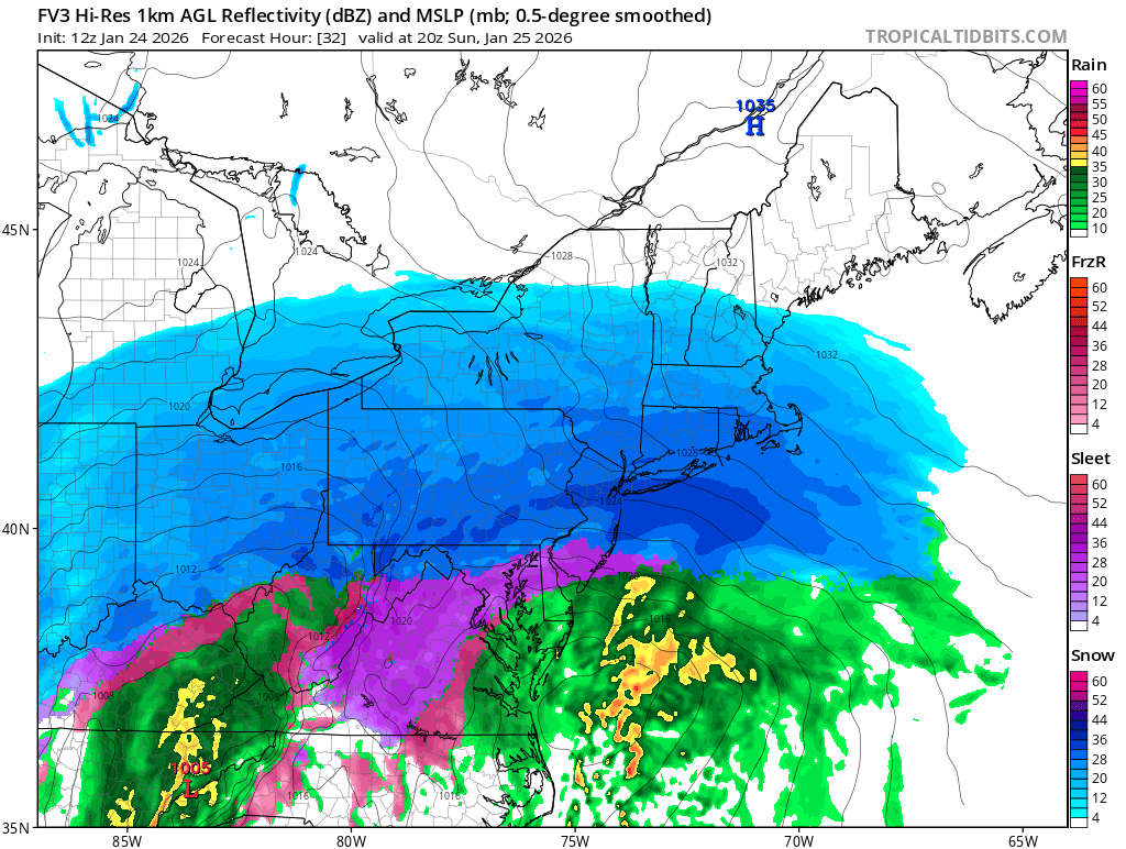
FV3 ticked N with the mixing. A little less white a little more ice. Scary thing is there is still 24 hrs to go this could continue to trend worse. This is turning into a major ice situation for SE PA now? -

January 25-26 Winter Storm Potential
Mikeymac5306 replied to Ralph Wiggum's topic in Philadelphia Region
If that's the case, I am wondering how bad the Ice will be? Not 1994 like but maybe 2014 like? -

Extreme Cold, Snow & Sleet: SECS 1/25 - 1/26
donsutherland1 replied to TriPol's topic in New York City Metro
On a more serious note regarding the NAM, the RGEM's high-resolution model and most of the global models use 4dVAR (four-dimensional variation) initialization. The NAM uses the older 3dVAR (three-dimensional variation) initialization. The general idea of warmer air moving in to change the snow to sleet in coastal areas and the New York City area and its nearby suburbs is the baseline idea due to lots of support. It's uncertain whether the NAM is overdoing things on account of its older initialization scheme or if it sees something the other guidance doesn't. If it begins to adjust late today (18z or later), that could be an indication that the older initialization process was playing a role. If, on the other hand, the other guidance starts shifting, that will indicate that the NAM, despite its limitations, had correctly resolved some of the details ahead of the other guidance. -

“Cory’s in LA! Let’s MECS!” Jan. 24-26 Disco
TauntonBlizzard2013 replied to TheSnowman's topic in New England
It burped north for one panel, and it was close. Think I’d be okay here -

“Cory’s in LA! Let’s MECS!” Jan. 24-26 Disco
WxWatcher007 replied to TheSnowman's topic in New England
Even if the coast gets pingers, I strongly believe it'll be after they get obliterated. So that's even better for you. I don't think you or my place in EH mixes. CT coast in a few miles inland SE CT, sure. Just don't think it'll be substantive. -
You may also have my favorite occurrence today bc of dynamics- thundersleet....it ain't a real storm in Texas without it lol
-
 .
. -
.
-
My friend in Lexington Tn and I-40 in his area .
-

Extreme Cold, Snow & Sleet: SECS 1/25 - 1/26
Winterweatherlover replied to TriPol's topic in New York City Metro
Yes the RGEM which also has a warm bias being generally snowy is also why I'm holding out hope the NAM is wrong. -

Arctic Hounds Unleashed: Long Duration Late January Cold Snap
dendrite replied to WxWatcher007's topic in New England
“Only” -39° for Tower….still waiting on Embarrass. -

Jan 24-26 Weekend Snow and Sleetfest Model Thread Part Tres
mitchnick replied to H2O's topic in Mid Atlantic
Nams have sleet all the way into southern CT & RI. Just wait Boston, the sleet's coming for you too! -
Careful with that talk, Some may associate that with paint peeling to the NH border.
-
“Cory’s in LA! Let’s MECS!” Jan. 24-26 Disco
TauntonBlizzard2013 replied to TheSnowman's topic in New England
NAM is high end here. Wow. 1.6” qpf -

Extreme Cold, Snow & Sleet: SECS 1/25 - 1/26
MJO812 replied to TriPol's topic in New York City Metro
Agree Fv3 is all snow and a big thump
-
 Beautiful. We've been gradually working on getting out land cleared on Window Rock Rd. I'm eyeballing an area on the brow to level for a possible weekend camper until we decide to build. I'm anxiously awaiting for Travis to get the license for approval for the diner and pizza oven fired up at Rolling Oaks. I might look at his Facebook page for an update. Sent from my SM-S916U using Tapatalk
 -
Arctic Hounds Unleashed: Long Duration Late January Cold Snap
dendrite replied to WxWatcher007's topic in New England
It’s still -20° in Flint. Wtf -
What a depressing end of the modeling for this storm. Just a run of the mill 4-7in slop storm for many
-

January 24-26: Miracle or Mirage JV/Banter Thread!
konksw replied to SnowenOutThere's topic in Mid Atlantic
I could show other ways for it to fail with a crayon. But that doesn’t mean they’re right. -

“Cory’s in LA! Let’s MECS!” Jan. 24-26 Disco
WeatherGeek2025 replied to TheSnowman's topic in New England
i'm north of the city, I think NAM is on crack -

“Cory’s in LA! Let’s MECS!” Jan. 24-26 Disco
RUNNAWAYICEBERG replied to TheSnowman's topic in New England
It was amped and warmer. Sleet line up to 84, RI, and you. -

Jan 24-26 Weekend Snow and Sleetfest Model Thread Part Tres
mdhokie replied to H2O's topic in Mid Atlantic
Yea I remember in the early 90s having to take a hammer and chisel to our driveway because there was at least 1/2" of ice on everything. It actually was a bad thing that we shoveled the snow off because anything that still had some snow left on it, the ice came up easy. Bare surfaces the ice had adhered to and didn't want to let go. -
.thumb.png.4150b06c63a21f61052e47a612bf1818.png)
“Cory’s in LA! Let’s MECS!” Jan. 24-26 Disco
HIPPYVALLEY replied to TheSnowman's topic in New England
Man, this thing is going to come in like an absolute wall of white. -
Extreme Cold, Snow & Sleet: SECS 1/25 - 1/26
Winterweatherlover replied to TriPol's topic in New York City Metro
If the NAM is right just hope it's sleet and not ZR.