All Activity
- Past hour
-
The NAO thing does not seem to hold much weight in the last 30 years. We have had quite a few very negative Octobers and most of those winters ended up +, obviously most winters have been + so many positive Octobers had positive NAO winters too. The most positive thing so far continues to be the NATL SST anomalies
-

Spooky Season (October Disco Thread)
tamarack replied to Prismshine Productions's topic in New England
Your B-Day in 2002 was memorable here, though with only a trace of snow on the ground. It was the first day of Maine's firearm deer season and at dawn it was 14° with gusts 30+. That would be ho-hum in January but was quite chilly in mid Autumn. (Punched my ticket with a nice critter the day after T-Day.) -
(002).thumb.png.6e3d9d46bca5fe41aab7a74871dd8af8.png) Hi Hazwoper....you may not be clear on what data I use It is only for Chester County PA. It is a combo of NWS COOP Trained Spotter /AWOS /DEOS , USCR and GOES data sourced data points. If in doubt take a look at my website which lists and links to all of the data points at www.chescowx.com I draw no conclusions but do assume there exists no known climate fence around the perimeters of beautiful Chester County PA LOL!!
Hi Hazwoper....you may not be clear on what data I use It is only for Chester County PA. It is a combo of NWS COOP Trained Spotter /AWOS /DEOS , USCR and GOES data sourced data points. If in doubt take a look at my website which lists and links to all of the data points at www.chescowx.com I draw no conclusions but do assume there exists no known climate fence around the perimeters of beautiful Chester County PA LOL!! -
Yea that mostly sunny forecast is a bust
-
After seeing the sun for a few minutes its clouded quite a bit
-

Spooky Season (October Disco Thread)
Lava Rock replied to Prismshine Productions's topic in New England
so the monday event is off the table? -

E MDR AEW: models support Car. TCG next wk
WxWatcher007 replied to GaWx's topic in Tropical Headquarters
Probably comes about too late for my peak season forecast -
@MillvilleWx
-
Moving to Banter... Remember that snow well. Lived in Lorton at the time at the intersection of Rt-1 and Pohick Rd. Had a class downtown DC that week. The forecast in the morning was for a dusting or very light snow, or so. My colleague from Woodbridge and I drove to the class together in his Isuzu Trooper. Having experienced surprise events in DC before we threw in some foul weather gear and a long chain and tow strap (we joked about going overboard at the time). Got to class in DC on 23rd street across between the Kenndy Center and west entrance to Dept of State HQs w/o any issues. Snow started mid-morning. By 11 it was puking fatties. USG closed soon thereafter. We made the mistake of pulling a few people out of the parking lot at the facility we were at on and that cost us precious time getting across the Potomac. Took about 3 hours to get to and through old town Alexandria. The roads around the Pentagon quickly became gridlocked on the major arteries and side streets. The news that night said there were 800+ cars abandoned just IVO of the Pentagon. Channel 4 showed video clips of commuters in dress clothes walking on 395 in both directions. After we got through Old Town things moved decently on the Mt. Vernon pkwy until about a half mile from Mt. Vernon. Two large pines fell across the Pkwy just in front of us which closed the Pkwy in both directions travel (it was a very heavy snow). We drove to the front of the stalled traffic with the Trooper and hooked up the chain to one of the pines near the top, which was out in the middle of the Pkwy. Used the length of the tree as a lever arm to pivot the tree around. Of course, w/o any weight we lacked traction to do much, even in 4-low with the center diff locked. Only moved it a few feet initially. So, we commandeered drivers from other cars for weight. We had people in the back seat, in the rear luggage compartment, hanging on the doors, sitting on the hood, sitting on top of each other - about anyplace they could get weight on the Trooper. It was like the car stuffing competitions they used to do in the 60's. Think we counted 13 plus the 2 of us, which was probably 3000+ lbs of dead weight. That did the trick. We pulled both the trees around on a pivot enough to get one lane open in both directions. It was a great example of what can be done with a little know-how and some willing cooperation to prevail amidst a desperate situation... Will never forget the cheer from all the drivers when we opened the road again. There was zero help from local authorities. It was also interesting to see the types of people around. Those who were willing and eager to help, and those who just stood by and did nothing but watch. Would not lift a hand but kept complaining about the situation. We didn't just admire the problem - we did something about it! but the ordeal was long from over. We got on route 1 southbound by Ft. Belvoir. Stood still for 30 mins w/o moving. Turned around and drove back to Ft. Belvoir, drove through the base and got to Backlick Road Northbound (before the FFCO Pkwy was extended to route 1) and managed to get to I-95 Southbound. Traffic was moving, but at a crawl. The snow was still pounding. We crawled Southbound on 95 until we got to the Pohick Road overpass above I-95. I bid by colleague farewell, got out of the Trooper and climbed over the fence along the side of the I-95 right of way. Climbed up the hill to Pohick Road, which was not easy to do even with boots on. When I got on Pohick I looked back to see about 15 other people doing the same thing, some in wingtips and women in heels. Everyone helped each other get up the steep incline onto Pohick road, where everyone went their own way. I walked about a mile the rest of the way home. From the time we departed the parking lot to when I got home was 7 hours. Took my colleague 3 more hours to get to his home in Woodbridge. We got 12"+ from the event which ended just before sunset. Yes, it can snow here in November.
-
Looking at Newark, New Jersey, it's not as clear cut. It's teetering on the edge of summertime, as there is only one colder meteorological summer month in the expanded history (June 1903), although the mean high in June 1859 was only 0.1F warmer than the first two weeks of October 2025.
-
Strongest gust, mid 50s, came in a June 2005 TS and toppled a half dozen popple trees. However, December 18, 2023 - four hours of 50+ gusts plus a storm total of 4.21" - was a far more destructive event, causing many times more tree damage on our woodlot. Floyd (Sept 1999) also had gusts approached 50. Greatest lifetime winds: 1-A: Nov. 25, 1950. the Great Appalachian Gale 1-B: Dec. 31, 1962, backside NW wind from the blizzard that ate BGR. Both events reached near 70 mph and caused major damage. 3: Aug. 19, 1991, "Bob" - 60+ gusts. 4: Aug. 28, 1971, "Doria" - near 60 5: April 7, 1982, East Coast April blizzard, also near 60
-
I would say this is endless summer. At least it is in Ohio, not sure about New York City. This is one thing you often overlook by focusing on the anomalous past warm years, there were a lot of historic years that were VERY cold. Looking at Cleveland, the first two weeks of October is running warmer than several historic Junes and even some of the coldest Augusts. Nobody would say June or August aren't summer months, just because they are colder than average. So if those months were colder than this October, and yet still considered to be summer, I would say you must accept that it is still summer. The mean high temperature for October so far is 72.7F. We can see there were 18 historic Junes with mean high temperatures for the month at or below that temperature, most recently in 1972. And, for August, we can find one cooler year (1927) and one just 0.1F warmer than this October to date (1915). Nobody would say August 1927 wasn't a summer month.
- Today
-
URGENT - WEATHER MESSAGE National Weather Service Baltimore MD/Washington DC 942 AM EDT Wed Oct 15 2025 MDZ003-501-502-509-510-VAZ025>031-503-504-WVZ050>053-055-501>506- 152145- /O.NEW.KLWX.FZ.A.0004.251017T0600Z-251017T1300Z/ Washington-Extreme Western Allegany-Central and Eastern Allegany- Western Garrett-Eastern Garrett-Augusta-Rockingham-Shenandoah- Frederick VA-Page-Warren-Clarke-Western Highland-Eastern Highland- Hampshire-Morgan-Berkeley-Jefferson-Hardy-Western Grant-Eastern Grant-Western Mineral-Eastern Mineral-Western Pendleton-Eastern Pendleton- 942 AM EDT Wed Oct 15 2025 ...FREEZE WATCH IN EFFECT FROM LATE THURSDAY NIGHT THROUGH FRIDAY MORNING... * WHAT...Sub-freezing temperatures as low as 28 to 32 degrees are possible. * WHERE...Portions of north central and western Maryland, northwest and western Virginia, and eastern and panhandle West Virginia. * WHEN...From late Thursday night through Friday morning. * IMPACTS...Frost and freeze conditions could kill crops, other sensitive vegetation and possibly damage unprotected outdoor plumbing. * ADDITIONAL DETAILS...The coolest temperatures are likely in the valleys. PRECAUTIONARY/PREPAREDNESS ACTIONS... Take steps now to protect tender plants from the cold.
-
A "normal" year would be 10th hottest ever (excluding 2025's partial data). Note, as well, despite this "fib" factor on the normals, every single year since 2020 has come in above even these artificially elevated norms. Prior to 2020, only four years were at or above 52.5F (1921, 1931, 1998, and 2012) and yet they want us to believe/accept that this is the new normal? What game are they playing?
-
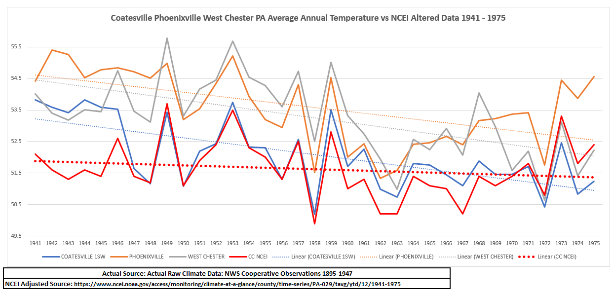
Notice the facts below how even that station that Charlie terms "consistent data" at Phoenixville was in reality missing around 20 years of data. from 1895 through 1914. Also take a look how those big 3 stations were all deeply discounted and adjusted downward. This includes both those stations that Charlie thinks are somehow heat island and those that are not....what again is the control arm used for these changes? How can the revised temperature not have any actual control station in the county that supports or aligns with the coolest station in the county? Instead NOAA adjusts to a figure so much lower with these post hoc altered adjustments to arrive at a revised temperature that is in fact not rooted at all to any factual temperatures of any stations at all in the entire county of Chester?
-
The normals aren't simple arithmetic averages. In fact, with the 1991-2020 normals, it looks like they were piloting some sort of new method of calculating them in Ohio, where the normals are significantly above the means. This is especially prevalent at Toledo, where the normal is an unbelievable 1.9F above the calculated mean. It appears to be a new methodology to factor in the warming trend, so more months are near or below average, instead of exclusively above average. Because of this change, even a "normal" year would be among the warmest ever recorded at Toledo. Just another way for them to hide the incline, I guess.
-
The above is a dystopian view not rooted in actual science, reality or facts....you point to faulty future state models to support your fears. Do you ever read what you post? The following words are why those that believe in some scary climate religion are now quickly losing followers. The fear mongering is pervasive in the above words and thoughts chosen by Don. He chooses words such as "crumbling coast" , "families watched helplessly", "erosion devoured", "tides insatiable pull", "ocean reclaimed", "destruction will spread", "societal sickness", "infection", "rejection of science", "sustainability breaks down", "deepening societal sickness", "narrowing window". Don where is this "tragedy of climate change"? All of those words and fear mongering you threw at us above only hurts the science you attempt to defend. This kind of narrative and post is exactly why folks are moving away from any belief that climate change is anything other than a typical cyclical occurrence. If we keep crying wolf like Al Gore about melting ice caps, increasing number of hurricanes, intensity and coastline obliteration followed by the verifiable facts failing to support these predictions this doubt about our future climate state will only deepen and spread....you can count on that!
-

Spooky Season (October Disco Thread)
GCWarrior replied to Prismshine Productions's topic in New England
Wait what are we tracking? Oh I see, tropical at hour 280 something with snow at the end potential. Be nice to get some snow in the high places before November 1st but please not here, still bike season, early snow is bad juju. Looks pretty nice the next few days until a little bit of rain Sunday night. -
No chatter on the impact of the block the rest of the month? While the Ideal Greenland Block shifts westward to Canada...its still a block and will be effective (I think) on sending eastward moving shortwaves Into negative tilt along and south of I80 for our area, the remainder of the month. That should mean additional meaningful rainfall and a couple good storms. I monitor ECAI my cyclic guide to what should happen as I find it particularly useful on yes/no. Not sure if anyone saw the CF-squall line gusts near 60 MPH vicinity Cape May Monday morning. Whether this occurs as attempted by the 05z EC OP 5-6 days in advance... it's a small possibility. No thread for us but bumpy flights eastern quarter of the country later Sunday-Monday morning and some decent 1-3" rains. I'll be curious as to the drought outlook changes eastern NJ/se NYS/CT when it posts tomorrow morning.
-
Need to watch for some severe storms on Sunday
-
Reminder: there’s a dedicated thread for this potential storm: https://www.americanwx.com/bb/topic/62328-e-mdr-aew-models-support-car-tcg-next-wk/
-
Gfs and euro both have a decent amount of rain on Monday
-
More on the 1987 record cold 1987 Unseasonably cold weather continued in the eastern U.S., with thirteen cities reporting record low temperatures for the date. The low of 34 degrees at Montgomery, AL was their coldest reading of record for so early in the season. Daily record lows included: Sterling (Dulles Airport), VA: 28°, Trenton, NJ: 30°, Allentown, PA: 30°-Tied, Columbia, SC: 32°-Tied, Harrisburg, PA: 32°-Tied, Macon, GA: 33°, Baltimore, MD: 33°-Tied, Parkersburg, WV: 34°, Chattanooga, TN: 34°, Islip, NY: 34 (later tied in 2006) °, Montgomery, AL: 34°, Bridgeport, CT: 36°, Augusta, GA: 36°-Tied and New York (Kennedy Airport), NY: 39°. Harrisburg, PA 32 °F (The National Weather Summary)
-
Records: Highs: EWR: 86 (1956) NYC: 84 (1956) LGA: 83 (2021) JFK: 82 (1975) Lows: EWR: 32 (1937) NYC: 32 (1876) LGA: 39 (2009) JFK: 37 (1999) Historical: 1608: Evangelista Torricelli, the Italian physicist and mathematician who invented the barometer was born on this date. In 1644, Evangelista Torricelli, built the first barometer with mercury. The aneroid barometer was made first in 1843, the French scientist Lucien Vidie invented the aneroid barometer. (Ref. AccWeather Weather History) 1876: Snow fell on the backside of a coastal storm from Virginia to New England. New York City, NY had its earliest 32° temperature and a half inch of snow. Fall River, MA reported 3.5 inches of snow. (Ref. AccWeather Weather History) 1880: This was the beginning of what was called the Mid West "Snow Winter of 1880-81". People were trapped in their homes and by the end of the winter it was reported snow was around 11 feet deep. 1880 - A violent early season blizzard raked Minnesota and the Dakotas. Winds gusted to 70 mph at Yankton SD, and snow drifts 10 to 15 feet high were reported in northwest Iowa and southeast South Dakota. Saint Paul MN reported a barometric pressure of 28.65 inches on the 16th. Railroads were blocked by drifts of snow which remained throughout the severe winter to follow. Gales did extensive damage to ship on the Great Lakes. (15th-16th) (David Ludlum) (The Weather Channel) 1947: People question attempts to weaken a hurricane by seeding it with dry ice after it made an unexpected turn off the coast making landfall near Savannah, GA with winds of 100 mph. One person was killed. Damage totaled $3 million dollars. (Ref. AccWeather Weather History) 1954 - Hurricane Hazel struck the Carolina coastline. The hurricane demolished every pier along a 170 mile stretch from Myrtle Beach SC to Cedar Island NC, and obliterated entire lines of beach homes. Hurricane Hazel also destroyed 1500 homes as it moved inland with seventeen foot tides. Winds between Myrtle Beach SC and Cape Fear NC gusted to 150 mph. Hurricane Hazel caused 163 million dollars damage, and claimed the lives of 98 persons. (David Ludlum) (The Weather Channel) 1954: By 11 pm on the 15th, Hurricane Hazel had reached and crossed the waters of Lake Ontario, still sporting sustained winds as high as 60 mph. Hazel took direct aim at the heart of Toronto as it roared past at 49 mph. Toronto saw heavy rainfall before Hurricane Hazel on the 14th. The previous storm, in combination with the hurricane, resulted in significant flooding. 1966 - Iowa experienced its worst late season tornado of record. In just one minute a twister tore through the town of Belmond leveling 75 percent of the businesses, and 100 homes, causing more than eleven million dollars damage. (The Weather Channel) 1984: The Monday Night Football game in Denver, Colorado, was played in a raging blizzard. 15 inches of snow fell with up to 34 inches reported in the nearby mountains. The Air Force Academy canceled classes for the first time in its' recorded history. 1987 - Unseasonably cold weather continued in the eastern U.S., with thirteen cities reporting record low temperatures for the date. The low of 34 degrees at Montgomery AL was their coldest reading of record for so early in the season. Lows of 32 degrees at Harrisburg PA and 34 degrees at Parkersburg WV marked their third straight morning of record cold. (The National Weather Summary) 1988 - The cold high pressure system responsible for the record low temperatures in the eastern U.S. began to move out to sea, giving way to a trend toward "Indian Summer". Thunderstorms developing ahead of a cold front produced golf ball size hail at Altamont KS and hail two inches in diameter at Yates City IL. (Storm Data) (The National Weather Summary) 1989 - Hurricane Jerry made landfall at Galveston, TX, at 6 30 PM (CDT). Winds at the Galveston Airport reached 75 mph, with gusts to 100 mph. Tides along the island were six to eight feet, and rainfall totals ranged up to slightly more than six inches north of Beaumont. Three persons were killed when their vehicle was blown off the Galveston seawall into the pounding surf. Total damage along the Upper Texas Coast was estimated at fifteen million dollars. Thunderstorms produced severe weather in Lower Michigan during the late morning. Two persons were injured when a tree fell on their camper at the Traverse City State park. While strong northerly winds ushered much colder air into the central U.S., unseasonably warm weather continued in the south central and eastern U.S. The afternoon high of 82 degrees at Bluefield WV was a record for October. (The National Weather Summary) (Storm Data) 2005: On this date through the 17th, the summit of Mt. Washington, NH reported 34 inches of snow. The 24-hour record for the most snowfall occurred when 25.5 inches fell in 24 hours. (Ref. Wilson Weather History) (Ref. WxDoctor)
-
58 / 52 partly cloudy and 96 hours of clouds finally gone with a brief return / warmup to the 70s for some (first since Oct 8th). Chilly next 48 hours before warming up this weekend and most sites getting back to low - mid 70s Sat for some Sunday for most. Front brings next round of storms/showers and rains Monday. Beyond there back and forth overall warmer than normal.