All Activity
- Past hour
-
29 years ago tonight and tomorrow, Hurricane Fran created a nightmare of destruction across Virginia. Winds to nearly 53 mph and nearly 8 inches of rainfall at my place.
-

September 2025 OBS-Discussion centered NYC subforum
wdrag replied to wdrag's topic in New York City Metro
May start a thread at 630AM Saturday for OBS-NOWCAST fairly widespread svr and a few Possible FF along I95 corridor. Model trends important and so am not committed yet but I think we're going to be pretty interested in the activity, especially for SEPT. SVR threat seems larger than the FF due to the recent dryness on and east of I95. However NNJ - central NJ inside of I95... be on your toes and no hanging out on stream banks once this system gets going. There were very sharp rises (and falls) of small streams last evening . Might be more extreme tomorrow. Aquiet period Sat evening before the widespread moderate rains with embedded thunder occur overnight Sat. Eastern LI probably not too much til maybe e Sunday morning -
More 30s on the way for tonight and tomorrow night. Gave in and turned on the ol' furnace. Gotta be a record earliest for that here.
-

2025-2026 ENSO
donsutherland1 replied to 40/70 Benchmark's topic in Weather Forecasting and Discussion
Here you go:
-
some models have 91l forming in the subtropics but I've already pressed X to doubt the atlantic = dubai or Karachi RIGHT NOW
-
Sunday is ruined. Wire to wire Rainer
-
Snowman19 seeing this post.

-
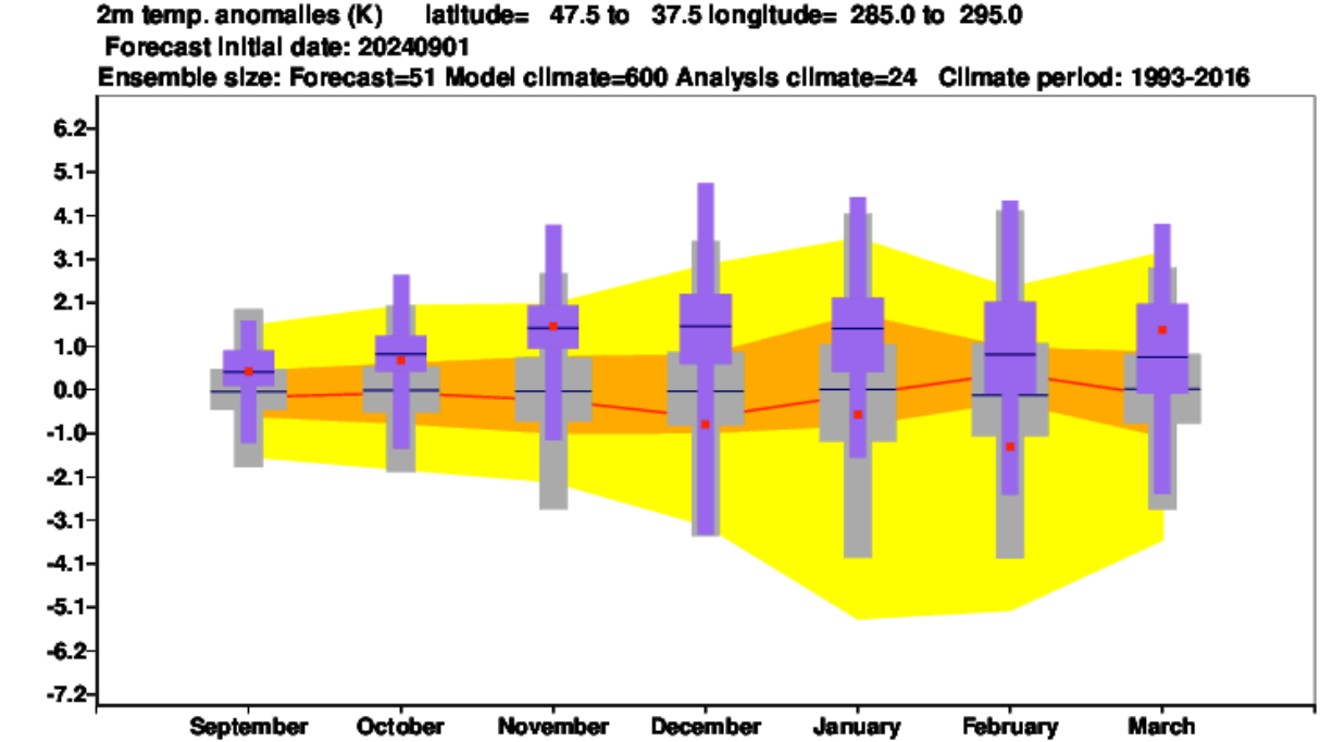
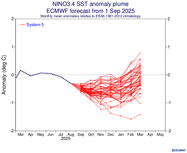
I just found Sept 2M forecasts for Dec and Jan individually though not Sept for DJF: https://charts.ecmwf.int/products/seasonal_system5_standard_2mtm?area=NAME&base_time=202509010000&stats=ensm&valid_time=202510020000 @donsutherland1@mitchnick
-

2025 Atlantic Hurricane Season
BarryStantonGBP replied to BarryStantonGBP's topic in Tropical Headquarters
Now GDM has 91L "Gabby" reforming in the subtropics "Humberto" becomes long track CV major "Imelda" goes for the gulf -
2025-2026 ENSO
donsutherland1 replied to 40/70 Benchmark's topic in Weather Forecasting and Discussion
It was. Notice how similar the map looks to last September's outlook for the past winter. I suspect that the similarity reveals that the expected ENSO state plays a disproportionate role in the seasonal forecasts. -
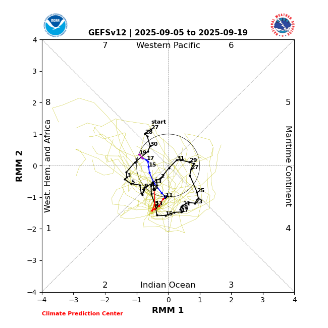
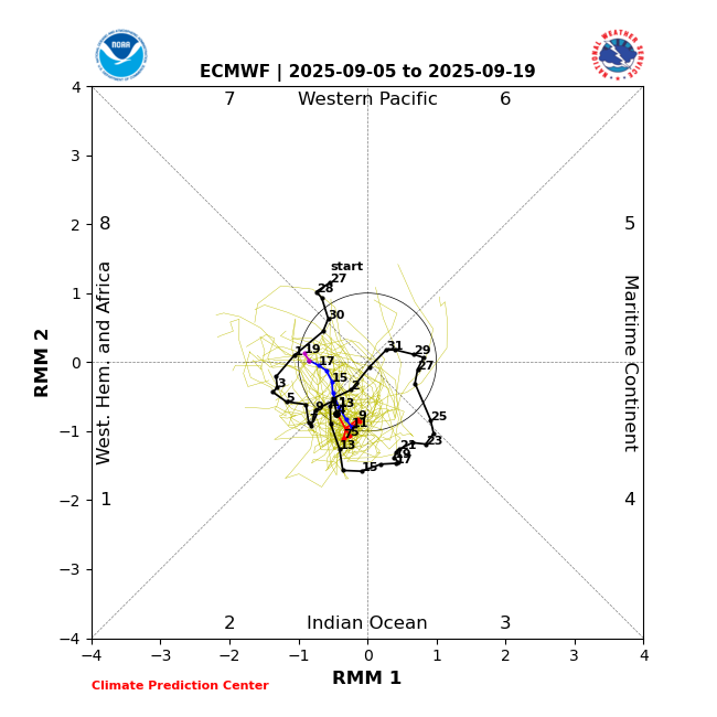
In addition: The last few GEFS and EPS runs have forecasted MJO in the relatively favorable phases of 2, 1, and 8 through Sept. 19 and this would probably extend at least through the rest of Sept per longer term model guidance and climo:
-
September 2025 OBS-Discussion centered NYC subforum
donsutherland1 replied to wdrag's topic in New York City Metro
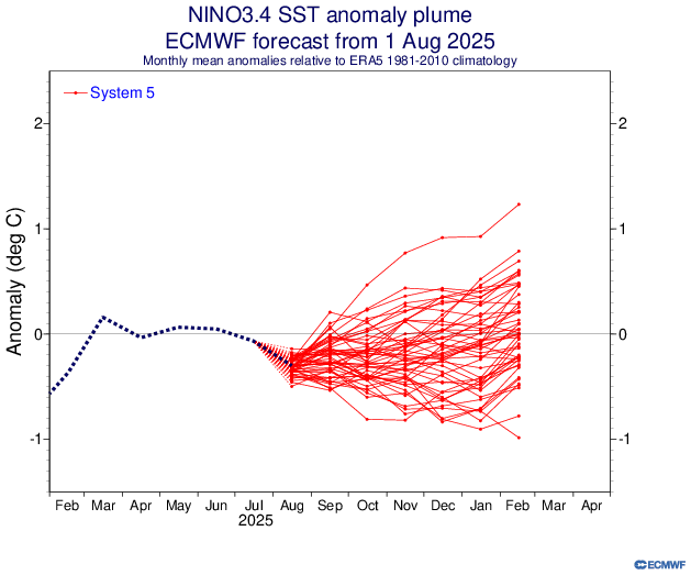
Overnight, New York City saw its biggest one- and two-day rainfall since August 20 and August 20-21. The guidance has continued to increase rainfall amounts for later Saturday into Sunday with some of the guidance showing the potential for an inch or more of rain in places. As a result, this could be New York City's biggest rainfall since 2.64" fell on July 14. That rainfall was highlighted by an hourly figure of 2.07". September 6 will also be the 17th anniversary of a widespread rainstorm that produced daily record figures across the New York City region and nearby southern New England. Daily records set in 2008 included: Bridgeport: 2.90" Danbury: 5.96" Hartford: 5.22" Islip: 2.29" New Haven: 3.31" New York City-Central Park: 3.26" New York City-JFK Airport: 2.51" New York City-LaGuardia Airport: 3.21" Newark: 3.64" Poughkeepsie: 2.20" Providence: 3.95" Westhampton: 2.32" White Plains: 4.42" In terms of temperatures, tomorrow will be another warm day. Temperatures will top out in the lower and middle 80s before another cooler air mass moves into the region. A few of the warmer spots could top out in the upper 80s. Following the passage of a strong cold front, temperatures will mainly top out in the 70s during the daytime and fall into the 50s at nighttime in New York City through at least the middle of next week. Additional showers or rain is possible around midweek. The ENSO Region 1+2 anomaly was -0.3°C and the Region 3.4 anomaly was -0.4°C for the week centered around August 27. For the past six weeks, the ENSO Region 1+2 anomaly has averaged +0.33°C and the ENSO Region 3.4 anomaly has averaged -0.32°C. La Niña conditions will likely develop during mid- or late-autumn. The SOI was +17.71 today. The preliminary Arctic Oscillation (AO) was -0.231 today. -

September 2025 OBS-Discussion centered NYC subforum
weatherpruf replied to wdrag's topic in New York City Metro
you never know; i went out on the sound porgy fishing last year in early oct or so and just threw some ice in a bucket; it got so hot by noon the ice melted and i had to scramble lest the fish spoil; had to empty out the food cooler and toss the fish in the remaining ice; as it was a soft cooler, ice is a no no and it leaked out all the way home, which was a 3 hour ride back to nj.... -
Do you or does anyone else have a link that can be provided to past years’ Euro Sept 2m temperature forecasts going back however far they do for the respective upcoming DJFs for North America or the US? Edit: I found it kind of sort of. See post below. @donsutherland1@mitchnick
-

September 2025 OBS-Discussion centered NYC subforum
Stormlover74 replied to wdrag's topic in New York City Metro
Made it to 87 here -
The new Euro has DJF Nino 3.4 much cooler than last month with it at ~-0.50 vs last month’s -0.08: 8/1/25 Euro prog for DJF: -0.08 9/1/25 Euro prog for DJF: ~-0.50
- Today
-
To be clear 91L still has a chance. I’m more skeptical about a CAG especially mid month. That’s outside of climatology as @GaWx has noted. Late month and especially into October is prime time for that though. Anyone thinking we’re in for a quiet season because of conditions currently should look at what was posted earlier. This decade especially has been known for strongly backloaded seasons.
-
NHC drops from 90% to 70% for the SE Atlantic stuff
-
Good point—there was also a pretty big fail on genesis with Fernand.
-
Unfortunately, the 18Z joined the east trend. We *may* still be in the game along the 95 corridor in Maryland, but we’re running out of wiggle room. On the positive side, most guidance has a signal for some anafrontal rain, either during the late evening, overnight, or early Sunday hours.
-
Saco at Cornish, Maine is at 269 cfs. The listed low is 295 in 1995. Sandy River at Mercer is 57.1 cfs. Record low is 38.7 in 2002 while the 25th percentile is 86. August 2002 Was the driest with 0.88", and Jan-August was 3rd lowest. (Lowest J-A came the next year but Sept-Dec dumped more than 27", 57% of the year's total.)
-
Of course climate change is having an effect on certain things. Did anyone say it isn't? We can still acknowledge that and also acknowledge that directly attributing disasters like hurricanes, tornadoes, floods, etc to climate change is not a scientific endeavor. Now, if research shows that certain events are statistically becoming more common across large regions over a significant period of time that correlates to climate change (and there is a physical reason for it that also corroborates) then you have a starting point. Give nuance a chance. Or don't. I don't have much patience for those that adopt a rigid, religious, dogmatic mindset.
-
Nah, Moregarbage broke the back on July 11th.
-

2025-2026 ENSO
michsnowfreak replied to 40/70 Benchmark's topic in Weather Forecasting and Discussion
Pretty big fail last winter. -
Occasional Thoughts on Climate Change
donsutherland1 replied to donsutherland1's topic in Climate Change
I agree. At some degree of warming or ocean acidification/deoxygenation, the food chain dominoes will begin to fall. The precise levels where this will occur are uncertain. Even if they were well-established, I don't think that knowledge, alone, would galvanize human society. Unfortunately, if past extinction/mass extinction events are representative, once the food chain dominoes begin to fall, it will be too late to mount an effective response.