All Activity
- Past hour
-
Getting my pot roast on
-

Strong Nor'Easter/Hybrid Storm Late September 2026
TriPol replied to Rjay's topic in New York City Metro
GFS is west at hr 60 -

Strong Nor'Easter/Hybrid Storm Late September 2026
wthrmn654 replied to Rjay's topic in New York City Metro
Gfs is indeed more west but precip wise unkown waiting for it to load. -
This seems hyperbolic. Likely based off of op runs. The latest GEFS and EPS runs have high temps ranging from upper 60s to low 70s(even mid 70s) for the first week to 10 days of October. Nice, but not chilly for early Oct. Looks about the same as what we have now through the next several days.
-
Strong Nor'Easter/Hybrid Storm Late September 2026
wthrmn654 replied to Rjay's topic in New York City Metro
Early views says it's a bit west? -
Strong Nor'Easter/Hybrid Storm Late September 2026
wthrmn654 replied to Rjay's topic in New York City Metro
Waiting for gfs to hurry up and run is giving me grey hairs -
 online pharmacy india: Gen Indus Pharma - order pills online
 -

October Comes Early: Late September Multi-Hazard Hybrid Storm
CoastalWx replied to WxWatcher007's topic in New England
Looks like the AI GFS has been trained by Tblizz. -

E PA/NJ/DE Autumn 2026 Obs/Discussion
Hurricane Agnes replied to PhiEaglesfan712's topic in Philadelphia Region
Full Moon this weekend will exacerbate any coastal flooding and higher than normal tides. -
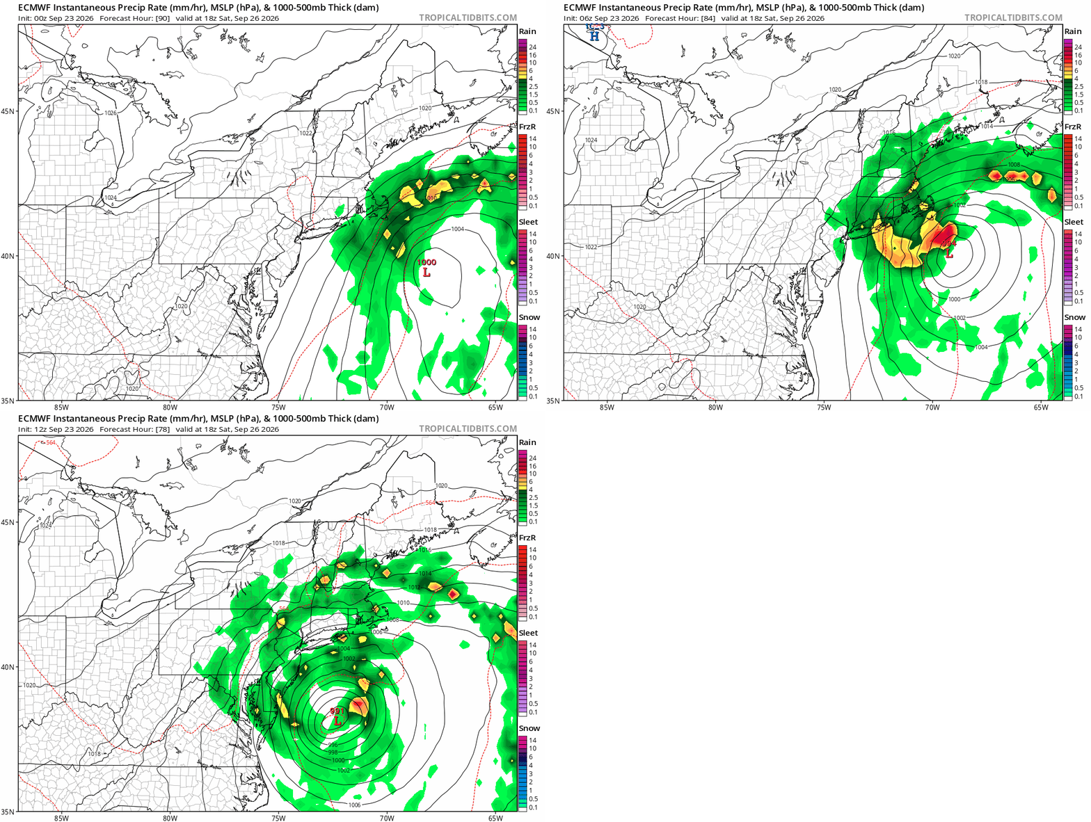
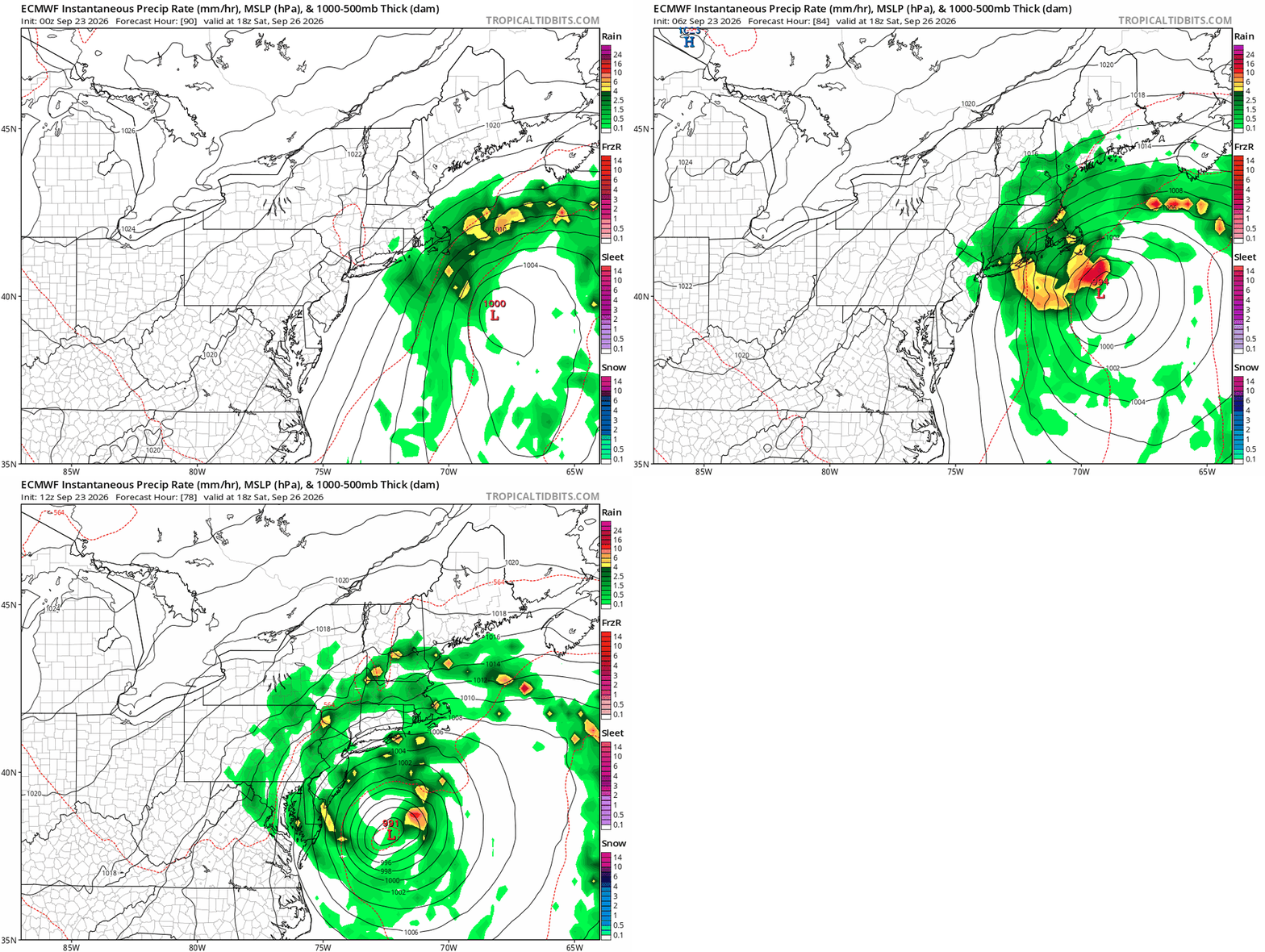
Models have again not done well handling this system. Now the euro has it back to impacting the area.
-

October Comes Early: Late September Multi-Hazard Hybrid Storm
SnoSki14 replied to WxWatcher007's topic in New England
People underestimating coastal impacts. Prolonged easterly flow, strong winds and rain with mod/major coastal flooding on top of full moon this weekend. But sorry it's not a Cat 3 that's about to destroy your house. -

2026 Atlantic Hurricane Season
WxWatcher007 replied to Stormchaserchuck1's topic in Tropical Headquarters
Fay is officially back from the dead. Tropical Depression Fay Discussion Number 15 NWS National Hurricane Center Miami FL AL062026 900 PM GMT Wed Sep 23 2026 Convection has redeveloped around the center of Fay and has persisted during the day. An earlier ASCAT pass indicated that the system still had a well-defined circulation. Therefore, Fay meets the criteria to be classified as a tropical cyclone again. The earlier ASCAT pass showed a maximum wind vector of around 31 kt and the most recent TAFB Dvorak classification was at T1.5/25 kt. Based on the given data, Fay's intensity is estimated to be 30 kt. The cyclone is moving just a little south of due west, or around 260/8 kt, as it moves to the south of a low- to mid-level ridge to the northwest. Fay is expected to continue on this general motion for the next several days. The current NHC track forecast is in line with the HCCA and GDMI forecast aids. There is a brief opportunity for Fay to regain tropical storm status during the next day or so, however wind shear is expected to increase again after 36 h. This should lead to the cyclone gradually weakening again, with the system becoming a post-tropical remnant low by 60 h, and then dissipating around 96 h, as suggested by simulated satellite imagery from the ECMWF global model. The current NHC intensity forecast track is in line with both the HCCA and GDMI forecast aids. FORECAST POSITIONS AND MAX WINDS INIT 23/2100Z 30.1N 39.2W 30 KT 35 MPH 12H 24/0600Z 29.9N 40.5W 35 KT 40 MPH 24H 24/1800Z 29.9N 41.8W 35 KT 40 MPH 36H 25/0600Z 29.9N 42.8W 30 KT 35 MPH 48H 25/1800Z 29.7N 43.7W 25 KT 30 MPH 60H 26/0600Z 29.5N 44.7W 25 KT 30 MPH...POST-TROP/REMNT LOW 72H 26/1800Z 29.5N 45.3W 20 KT 25 MPH...POST-TROP/REMNT LOW 96H 27/1800Z...DISSIPATED $$ Forecaster Katz/Pasch -
Strong Nor'Easter/Hybrid Storm Late September 2026
wthrmn654 replied to Rjay's topic in New York City Metro
Gale watches are already up lol -

Occasional Thoughts on Climate Change
Typhoon Tip replied to donsutherland1's topic in Climate Change
https://phys.org/news/2026-09-unevenness-global-regional-speedups-emerge.html -
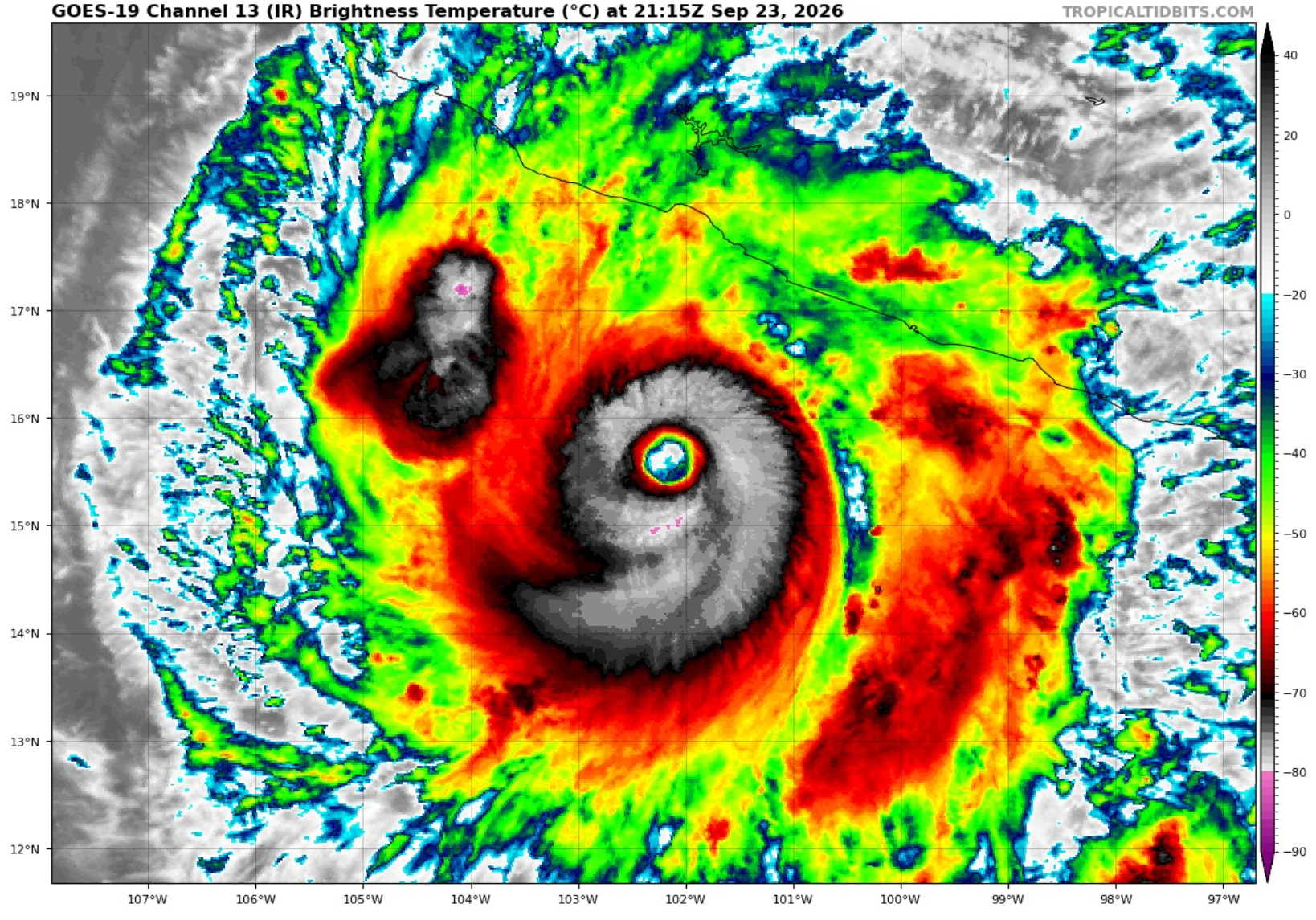
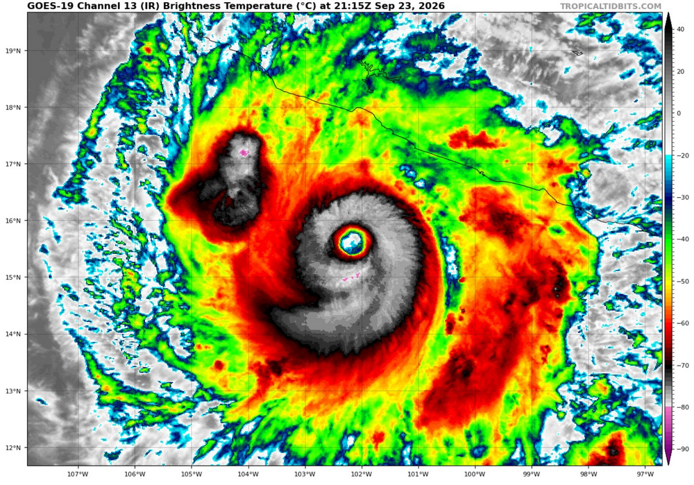
Looks like Polo has finished its ERC, I'm curious to see how strong it gets now.
-
Septorcher 2026 Discussion - Endless Summer
Typhoon Tip replied to Damage In Tolland's topic in New England
https://phys.org/news/2026-09-unevenness-global-regional-speedups-emerge.html -

Strong Nor'Easter/Hybrid Storm Late September 2026
uofmiami replied to Rjay's topic in New York City Metro
OKX has 24hr to issue an advisory for twin forks if need be. Let's hope by tomorrow morning the models all agree on the track & they'll move on advisories for out east if needed. -
Strong Nor'Easter/Hybrid Storm Late September 2026
wthrmn654 replied to Rjay's topic in New York City Metro
Was just talking to nws met, sounds like there talking a cautious approach. Watches from past experience,imo, we're always issued area wide at the same time roughly.. to see them doing things, more randomly? Versus watches for coastal flooding all areas that would likely see it is deft unusual especially with such a spread in models would seem more prudent to be safer then sorry? End rant -
Strong Nor'Easter/Hybrid Storm Late September 2026
TriPol replied to Rjay's topic in New York City Metro
Upton had balls last winter. Maybe they misplaced them when El Nino came. They should find them again because I have faith the 18z GFS is going to cause them to hoist Gale Watches. -
Strong Nor'Easter/Hybrid Storm Late September 2026
wthrmn654 replied to Rjay's topic in New York City Metro
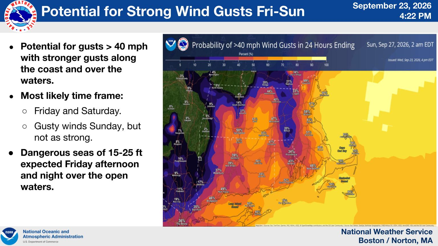
What blows my mind is how nws weather offices don't really seem to like to work either each other sometimes? Example, 430 pm Boston wind probability image shows eastern Long Island at 60%or better chance setting 40 or higher gusts. And places east. But Upton says likely stay below even advisory level...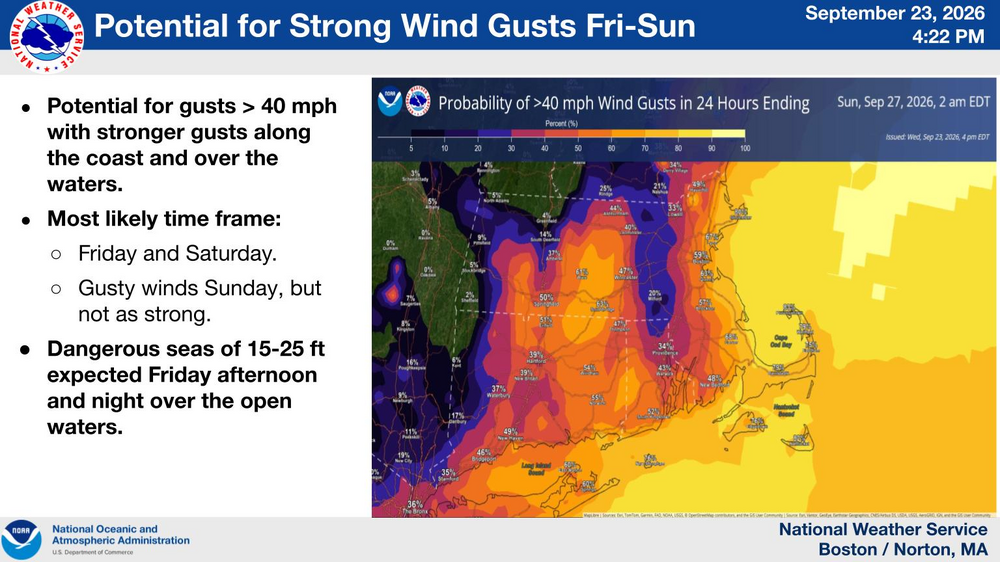
-

October Comes Early: Late September Multi-Hazard Hybrid Storm
SnowHole413 replied to WxWatcher007's topic in New England
Other than some rain and little wind, not a big storm. Pretty predestination, yall need to chill out -

October Comes Early: Late September Multi-Hazard Hybrid Storm
Layman replied to WxWatcher007's topic in New England
So many people generally don't like to see or know somebody else is having fun. Misery loves company. -
 Locking into final scenario
 -

Strong Nor'Easter/Hybrid Storm Late September 2026
Brian5671 replied to Rjay's topic in New York City Metro
same thing every noreaster-GFS flat out to sea then comes on board at the end -

October Comes Early: Late September Multi-Hazard Hybrid Storm
dendrite replied to WxWatcher007's topic in New England
ICON looks similar to 12z...hooks into MTP and rides the S LI coast. Pretty good rain event up here.