All Activity
- Past hour
-

E PA/NJ/DE Autumn 2025 Obs/Discussion
LVblizzard replied to PhiEaglesfan712's topic in Philadelphia Region
These dry periods are aligning nicely with my job as a college tennis ref. It always sucks to move a match or tournament indoors since that often means much longer days. I do really hope we get some good rain in the coming weeks though. We just really need a 3-4 day period of steady light rain. Feels like we haven’t had that in forever. -
Honestly this storm had organized at a quick pace overnight with pressure falls and a the center under the CDO. Think pace of intensification quickens through the day
-

September 2025 OBS-Discussion centered NYC subforum
TheClimateChanger replied to wdrag's topic in New York City Metro
1989 - Seven cities reported record high temperatures for the date, as readings soared into the 80s and low 90s in the Northern Plateau and Northern Plains Region. Record highs included 91 degrees at Boise ID, and 92 degrees at Sheridan WY. The high of 100 degrees at Tucson AZ marked their 51st record high of the year, and their 92nd day of 100 degree weather. (National Weather Summary) Seven? We had more than that yesterday. These are from RERs, so there could be some missing and the temperatures might vary higher than given. San Juan, PR: 95F Naples, FL: 94F Augusta, ME: 83F Portland, ME: 85F Allentown, PA: 86F Reading, PA: 87F Fort Wayne, IN: 89F New Philadelphia, OH: 87F DuBois, PA: 80F Marquette, MI: 79F New York (LaGuardia), NY: 85F Glens Falls, NY: 85F Albany, NY: 85F Newark, NJ: 89F Islip, NY: 84F Manchester, NH: 86F Additionally, Key West, FL had a record warm minimum of 83F. -
Agree with this. I will say that some of the AI models earned a little more respect with me this season, but to your point--it's going to take time to truly get a sense of how well it analyzes critical forecasting factors over the long term. Every forecast is different and every TC is a distinct entity. And at any rate...models are merely tools. So us laypeople should beware relying on any one as gospel in any situation. (not saying that anyone here is necessarily doing that)
-

2025-2026 ENSO
40/70 Benchmark replied to 40/70 Benchmark's topic in Weather Forecasting and Discussion
Here is a review of the QBO/Solar relationship for review/reference: The aforementioned Holton-Tan relationship, which dictates that an easterly QBO is correlated with both a greater incidence of, and an earlier development of SSW, becomes more complicated when considering the solar cycle. In some cases, when the QBO and solar cycle are in conflict, they can either over ride one another or even cancel each other out (Gray et al 2004). Here is a list of combinations and the theorized relationships for clarity. Solar min/W QBO: This is entirely consistent with the Holton-Tan relationship in that the westerly QBO essentially "wins". The PV is likely to be stronger than average until the final warming in spring. Solar max/W QBO: In this case, the Holton-Tan relationship is applicable early on in the season, as major warmings are unlikely. However, the Holton-Tan relationship reverses mid winter and the latter portion of the season from February onward is susceptible to warmings and major PV disruption. Winter 2024-2025 was a textbook example of this. Solar Min/E QBO: There are no inconsistencies here, as the entire season is more prone to polar vortex disruptions and SSW as per the Holton-Tan relationship. Solar Max/E QBO (2025-2026): The Holton-Tan relationship applies early on given that PV disruptions are likely in December, before the relationship reverses and they are less likely later in the season. The final warming is of course the exception to this rule, while it is usually more relevant for spring, it can and does sometimes occur early enough to have an impact for the major population centers in terms of late season cold and/or snowfall. -

Occasional Thoughts on Climate Change
LibertyBell replied to donsutherland1's topic in Climate Change
and the Atlantic is also smaller than the Pacific so melting polar ice would have more of an effect on the Atlantic I would guess. -
Absolutely not. Maybe it performed well for this one event, but that doesn't mean it's better than traditional NWP. You really need to conduct a thorough evaluation at the surface and aloft (for forcing variables) to make such conclusions. As an example, it's possible something can be right for the wrong reason. You wouldn't know unless you evaluated it... So, if AI did well with forcing, wrt NWP, over a duration of 1 year, then you can entertain the idea. This is just imo, but we're years, if not decades, away from this. We likely need to significantly improve data assimilation for this to occur.
-
September 2025 OBS-Discussion centered NYC subforum
LibertyBell replied to wdrag's topic in New York City Metro
Tony, we're going to have limited sunshine the next few days. Yesterday was the last of the sunny days until the colder weather comes in later in the week. -
September 2025 OBS-Discussion centered NYC subforum
LibertyBell replied to wdrag's topic in New York City Metro
It's not bad, better to have warmth now than in winter. -
2025-2026 ENSO
40/70 Benchmark replied to 40/70 Benchmark's topic in Weather Forecasting and Discussion
Yes, intuitively this is correct.....but that mid season SSW outlier group matches this year pretty well with respect to the solar and exact QBO. This is why I hedge towards the mid season SSW....will I be shocked if it doesn't work out? Nope- I do agree with a PV surge in early January after a rather tepid start, which likely concides with a stratospheric reflection event and subsequent +NAO/ poleward Aleutian ridging ala 2001, 2002, 2014, 2018. Probably a pretty warm stretch early in January. -

Spooky Season (October Disco Thread)
TheMainer replied to Prismshine Productions's topic in New England
We have a white Christmas well over 90% of the time, that day and one back in the 90s are the only ones I remember (not living in Southern Maine) that didnt meet the white Christmas definition. -
Also, this is an extraordinary satellite image. About as close as you can get. Both in coastal impacts and two TCs interacting with one another.
-
while this is true, the current ssta configuration in the tropics is favorable for MJO propagation with a warm pool in the west pacific that's backed by the subsurface along -QBO and an east based nina, so we should still be able to get a decent amount of poleward ridging episodes -QBO and solar max should cancel each other out but in general could be more open to -NAO/-AO episodes early on in winter(HT relationship for (+QBO/solarmax) says weak PV start, strong PV mid-late winter) I do think that we see more southeast ridging this winter in general though
-
September 2025 General Discussion
TheClimateChanger replied to Geoboy645's topic in Lakes/Ohio Valley
Certainly feeling incredibly blessed with this bonus summer. A couple of records tied yesterday in the subforum, with New Philadelphia, Ohio, topping out at 87F, and Fort Wayne, Indiana reaching 89F. 000SXUS73 KIWX 290544RERFWARECORD EVENT REPORTNATIONAL WEATHER SERVICE NORTHERN INDIANA0144 AM EDT MON SEP 29 2025...RECORD HIGH TEMPERATURE SET AT FORT WAYNE ON SEPTEMBER 28TH...A RECORD HIGH TEMPERATURE OF 89 DEGREES WAS SET AT FORT WAYNEYESTERDAY. THIS TIES THE OLD RECORD OF 89 DEGREES SET IN 1999.$$ 000SXUS71 KPBZ 290537RERPHDRECORD EVENT REPORTNATIONAL WEATHER SERVICE PITTSBURGH PA137 AM EDT MON SEP 29 2025...RECORD HIGH TEMPERATURE TIED AT NEW PHILADELPHIA OH...A RECORD HIGH TEMPERATURE OF 87 DEGREES WAS TIED AT NEW PHILADELPHIA OH YESTERDAY, SEPTEMBER 28 2025. THE RECORD OF 87 DEGREES WAS FIRST SET IN 2019.$$WM -
The wind field is still not particularly organized or strong, but the winds are gradually coming up as the satellite presentation continues to improve. The center is now under a developing CDO, with persistent deep convection we should see the pace of organization pick up over the course of the day. The pressure has continued to fall, with the latest center dropsonde showing a possible pressure below 990mb now. Product: Air Force Temp Drop (Dropsonde) Message (UZNT13 KNHC)Transmitted: 29th day of the month at 13:23ZAgency: United States Air ForceAircraft: Lockheed WC-130J Hercules with reg. number AF97-5304Storm Name: ImeldaStorm Number: 09 (flight in the North Atlantic basin)Mission Number: 22Observation Number: 10Part A... Date: Near the closest hour of 13Z on the 29th day of the month Highest Mandatory Level For Which Wind Was Reported: 925mb Coordinates: 26.6N 77.2W Location: 108 statute miles (173 km) to the N (5°) from Nassau, Bahamas. Marsden Square: 080 ( About ) Surface and Standard Isobaric Surfaces Level Geo. Height Air Temp. Dew Point Wind Direction Wind Speed 1000mb -93m (-305 ft) This level does not exist in this area of the storm above the surface level. 990mb (29.24 inHg) Surface (Sea Level) 26.0°C (78.8°F) 25.5°C (78°F) 135° (from the SE) 20 knots (23 mph) 925mb 596m (1,955 ft) 23.8°C (74.8°F) 23.2°C (74°F) 145° (from the SE) 15 knots (17 mph) 850mb 1,337m (4,386 ft) 21.6°C (70.9°F) 20.3°C (69°F) No Wind Report Available For This Level Information About Radiosonde: - Launch Time: 13:13Z - About Sonde: A descending radiosonde tracked automatically by satellite navigation with no solar or infrared correction. Remarks Section... Dropsonde Location: Dropped in center.
-
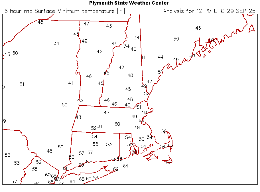
For 40s?
-
AI models picked up on this way before the conventional models…. I think its time to start giving way more stock to the ai models
-
I‘m not sure exactly what you’re asking. But I do know that both the Icon and the UKMET on every single run going back to when they first had this on their runs 5+ days ago had this after moving it N to NNW hook sharply right OTS. They were absolutely stellar and were far better than any other non-JMA models with their essentially perfect records. I have the JMA as a clear 3rd as only its 12Z 9/23 run hit NC. All others hooked sharply right and OTS although two of them (12Z 9/25 and 12Z 9/26) combined with Humberto to make one storm. All of this is still on Tropical Tidbits for those who are interested. They have runs back a full week. Check them out before it’s too late! Edit: The 18Z 9/24 Icon, which goes out only 120 hours, didn’t go out far enough to be able to tell for sure. It had Imelda further N than most other runs and she was getting pretty close to FL when the run ended. But she was moving very slowly and could have easily hooked right had the run gone out further as that’s about the time the right hook would have started.
-
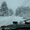
let it snow
-

Central PA Fall Discussions and Obs
Mount Joy Snowman replied to ChescoWx's topic in Upstate New York/Pennsylvania
Low of 60. Completely exhausted from this past weekend, being up at Penn State and the emotional roller coaster that ensued, then Green Bay getting a tie last night, with both games going into the wee hours. I’m shot. At least the upcoming weather looks delightful. -
So we'll have a cat 10, cool.
-
The most "fun" and "challenging" part of this weeks forecast is tomorrow's sky cover
-

Central PA Fall Discussions and Obs
sauss06 replied to ChescoWx's topic in Upstate New York/Pennsylvania
Perfect, opening night for the Bears -
Picked up another .19" last night. Up to 2.88" for the month.
-
Yes and no....I agree generally with what you are saying, but it's not the warming itself that is prohibitive to having good seasons....it's the western warm pool in-and-of-itself that is the reason NAO blocking hasn't been paying dividends....AKA +WPO. Do me a favor and find a great SNE season that also had a strongly +WPO......you can't find one...not in 1948, and not in 2025. https://psl.noaa.gov/data/correlation/wp.data Extreme +WPO being prohibitive isn't a recent development, but rather the consistency and strength of it is. Since 2016-2017, 2021-2022 is the only -WPO season we have had......the concern is that this is some sort of permanent pattern as a result of CC. While we won't know definitely for another 10 years or so, I am still of the opinion that the globe will find a way to achieve balance, and will wait before seeing otherwise. As for the WPO....we here in SNE can thrive with a modestly +WPO value, as was the case in 2017-2018....and yes, we can still get a -WPO season, as was the case in 2021-2022. That being said, SSTs over the eastern Indian ocean do look supportive of +WPO, but the hope is that more abundant E PAC warmth can counter that in much the same manner that the West warm Pool did with El Nino a couple of seasons back...think Relative Ocean Nino Index https://www.cpc.ncep.noaa.gov/data/indices/RONI.ascii.txt Always remeber that NOTHING operates in a vacuum, so don't obsess too over any single point on the globe, as ultimately it is not what is going on at said point that is paramount, but rather what is going on at said point relative to the rest of the globe.