All Activity
- Past hour
-

2026 Atlantic Hurricane Season
vortex95 replied to Stormchaserchuck1's topic in Tropical Headquarters
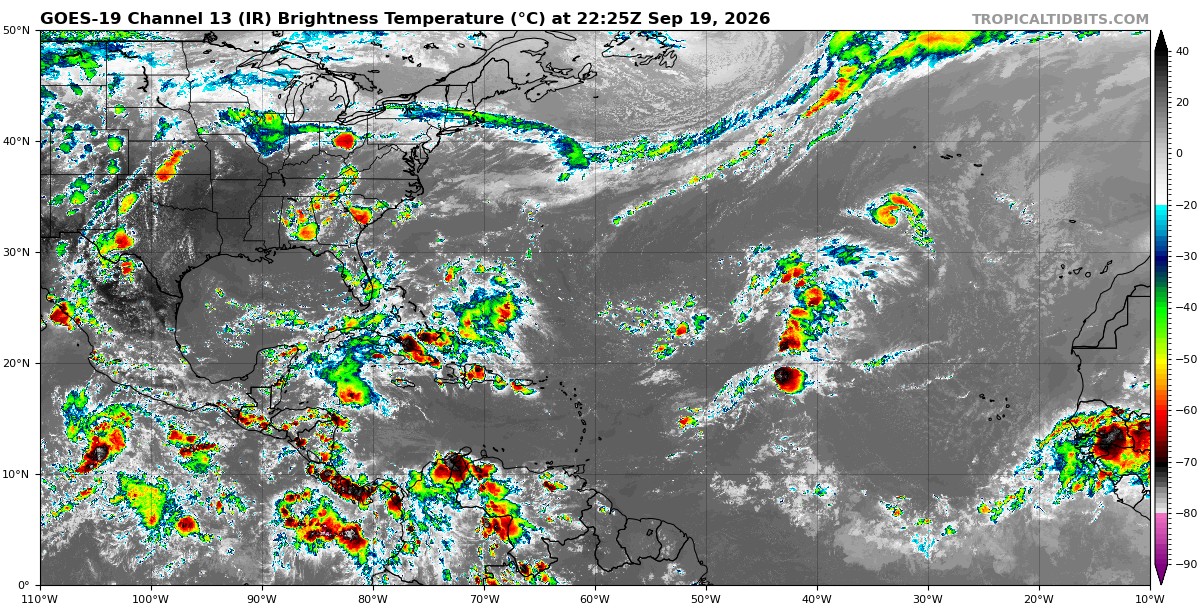
Talk about threading the needle. That anticyclonic cirrus shear plume is right on the doorstep of the core, and yet no shearing of the convection over the core. One thing about seasons like this, the TCs are often small. TD6 exemplifies this. At first glance in vacuum, you look at the EIR image below of the Atlantic, and go, "where is it?!" Areas of convection exists sig larger than TD6 here!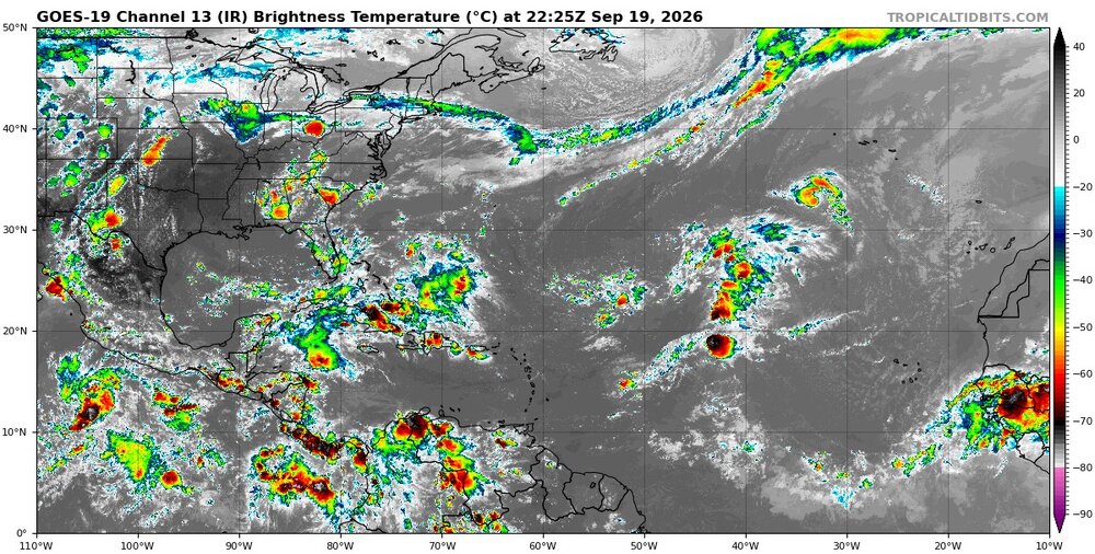
-
2026 Atlantic Hurricane Season
vortex95 replied to Stormchaserchuck1's topic in Tropical Headquarters
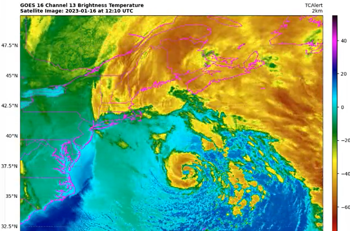
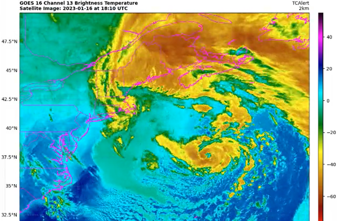
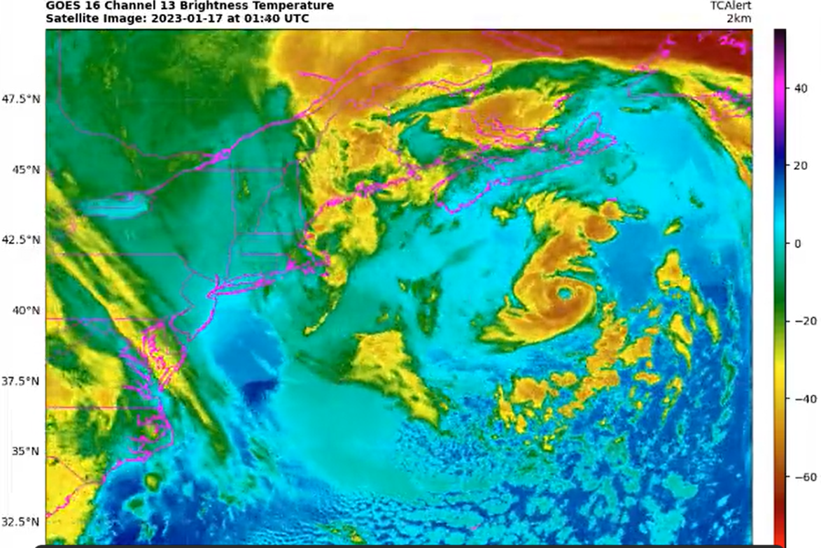
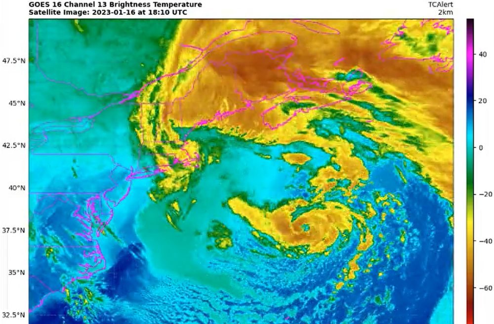
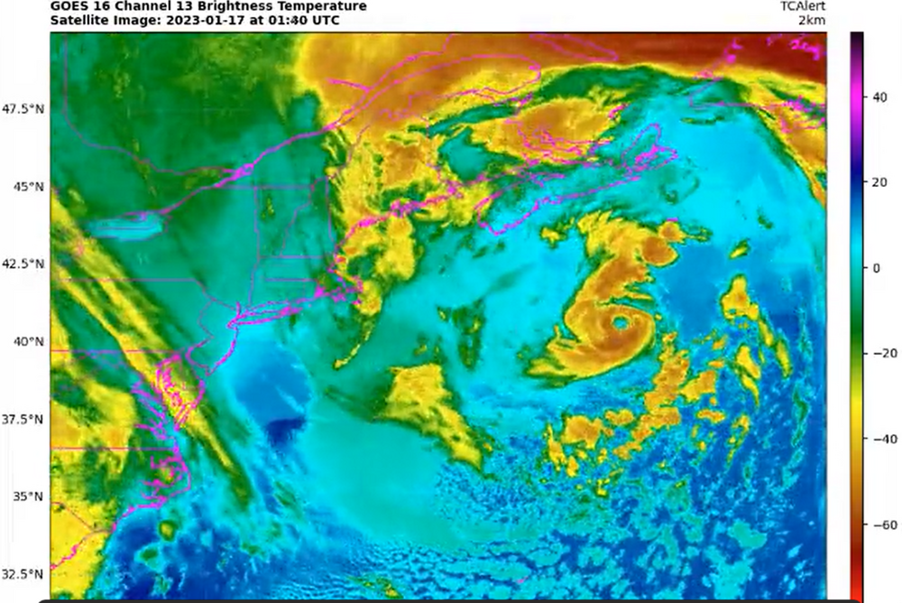
As much as they would not admit, sometimes that is a factor. Here is something similar. Recall the system S of New England Jan 2023? That was a hurricane, but they blew it off operationally. Yes, a few months later they included it as a 60 kt STS, but not operationally declaring it was it was clear was it was? So that suggests that if they can get away w/ not doing it operationally, and just let post-seasons analysis "deal w/ it," they will. Another motivation could have been that a hurricane close to the East Coast "out of blue" in Jan? The public and media would freak and perhaps they did not want to deal w/ all that, but again, we should not be summarily constrained by policy or social/political factors when it comes to operational meteorology and calling things for what they are. And this ended up impacting marine Canada, so it was not a "fish storm." And put it this way, we've see far worse looking systems declared/called a TC. So where is the meteorological consistency here? Loop here: https://x.com/WxTca/status/1615532584016162822 Sfc and SST analysis https://x.com/burgwx/status/1615099242728628231 That is a clear eye and quite deep convection for Jan. I got T4.5 on it (77 kt) using Dvorak. Now granted, SSTs were 21-23 C o that mean less efficient mixing down of winds aloft, but still 65 kt is likely here. Notice when it approached Sable Island crossing a very sharp SST gradient, it actually looked best! The center passed just W of Sable island which recorded sustained winds of 49 kt. That was over much cooler SSTs, so again, when it was farther SW over 21-23 C, 65 kt would be easy. This i not armchair quarterbacking, nitpicking, or a borderline TC situation. This system's nature was obvious and screaming at you, and the model fcsts handled it ET to T transition warm seclusion very well), so this was not a "surprise." Like I have said, call wx phenomena for that they are in real-time. The atmosphere doesn't care about human-imposed rules or what we think, it does what it does, and we all look at the same data, so by doing this, you prevent push back/calling out/criticism to yourself! And I see on this forum, ppl sometimes say, "I can't believe it hasn't been declared yet" or "it obviously stronger (weaker) than that!" That's not just random complaints/musings all the time, many times such statements and observations have merit or are true! loop.mp4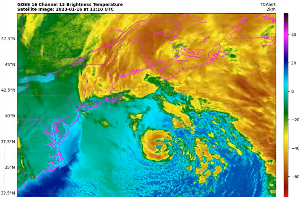
-
This pattern is extremely wet. It has rained six of the last seven days, with almost no sun in that period. I got another 0.81" this morning, with widespread 1-3" north and east of me. More heavy rain is expected tonight across the area as a disturbance rides up along the front.
-

Septorcher 2026 Discussion - Endless Summer
qg_omega replied to Damage In Tolland's topic in New England
Ok so best to expect a nice sunny day now -
A rainy period will likely develop tomorrow. Periods of rain could continue into at least the middle of next week. Temperatures will remain unseasonably cool throughout next week. The ENSO Region 1+2 anomaly was +4.5°C and the Region 3.4 anomaly was +2.9°C for the week centered around September 9. For the past six weeks, the ENSO Region 1+2 anomaly has averaged +4.23°C and the ENSO Region 3.4 anomaly has averaged +2.65°C. The ongoing strong El Niño, will continue to strengthen through the mid-fall. The SOI was -42.37 today. The preliminary Arctic Oscillation (AO) was +2.194 today. Based on sensitivity analysis applied to the latest guidance, there is an implied near 70% probability that New York City will have a cooler than normal September (1991-2020 normal). September will likely finish with a mean temperature near 68.2° (1.0° below normal). Supplemental Information: The projected mean would be 0.2° above the 1981-2010 normal monthly value.
-

Septorcher 2026 Discussion - Endless Summer
CoastalWx replied to Damage In Tolland's topic in New England
Definitely keep an eye on it. -

Septorcher 2026 Discussion - Endless Summer
Damage In Tolland replied to Damage In Tolland's topic in New England
That thing never had a chance . Couldn’t understand all the excitement and wildness -
Do some research. So much info from many outlets on this. Let AI help you. It isnt difficult to see why there could be a prolonged lockout/cancellation of a significant part of the season given the division over a hard cap ceiling/floor and revenue sharing between owners and players. Always about money, and both sides are dug in.
-
Didn't make it close to upper 70's predicted for today. 66 seems to be the max. A dark, gray, dreary "summer is over" kind of day.
-
Because everyone involved in professional sports is a greedy mf.
-
Septorcher 2026 Discussion - Endless Summer
CoastalWx replied to Damage In Tolland's topic in New England
Definitely chilly this aftn. Maybe some rain tomorrow and then more boredom. Not sure how much if any impact from that coastal. -
Made it to 101 today,should be a record On September 19, 1954...One of the hottest summers on record continues its strangle-hold on the mid state. Nashvilles high hits 97 degrees
-
Why do people believe the lockout is gonna take up the entire season? Not sure either side is gonna want that...we could still lose some games, though.
-
Albernaz being back I get--I looked up what other rookie managers were fired after Year 1 and couldn't find much! It is just not something MLB teams do very often (if at all). All managers like that historically get a second year. I think he's out if we miss the playoffs again next year. But Elias? Bruh...we finally got new ownership that spends more and let's the GM be the GM...but now Rubenstein is getting fooled by this dude, smh Two consecutive last place finishes under two different managers and he gets to keep his job? Dude has nine lives. If it happens again next season...what's gonna be the excuse? Shouldn't be any...but who knows? Smh
-
The good news for the Orioles next year is that there’s a strong possibility that they won’t play.
-

Septorcher 2026 Discussion - Endless Summer
moneypitmike replied to Damage In Tolland's topic in New England
Above average. Still normal. - Today
-
Septorcher 2026 Discussion - Endless Summer
moneypitmike replied to Damage In Tolland's topic in New England
When did you become such a debbie downer? -

2026-2027 Record-breaking El Nino
jaxjagman replied to Stormchaserchuck1's topic in Weather Forecasting and Discussion
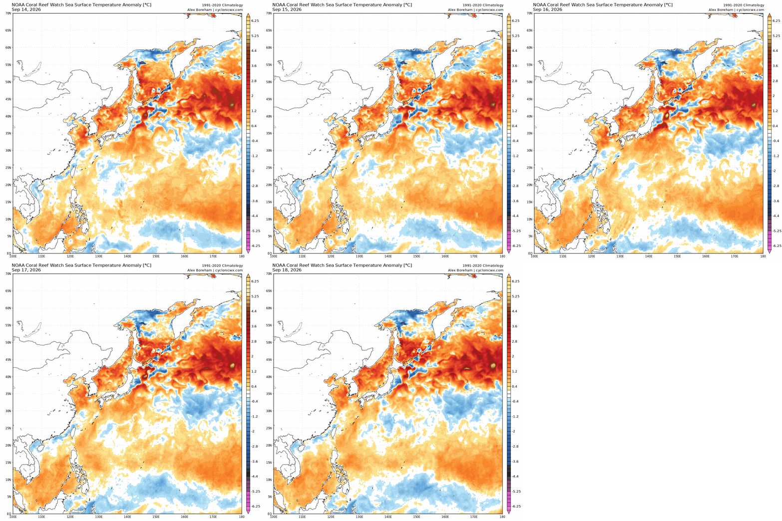
Yeah we are seeing a phoon finally going to recurve but seemingly all its doing is warming especially into Yellow Sea and Sea of Japan ,these waters should be cold and not warm,maybe baby steps not very impressive,maybe this could change as the storm moves off of Japan,but still it was nice to see this for a change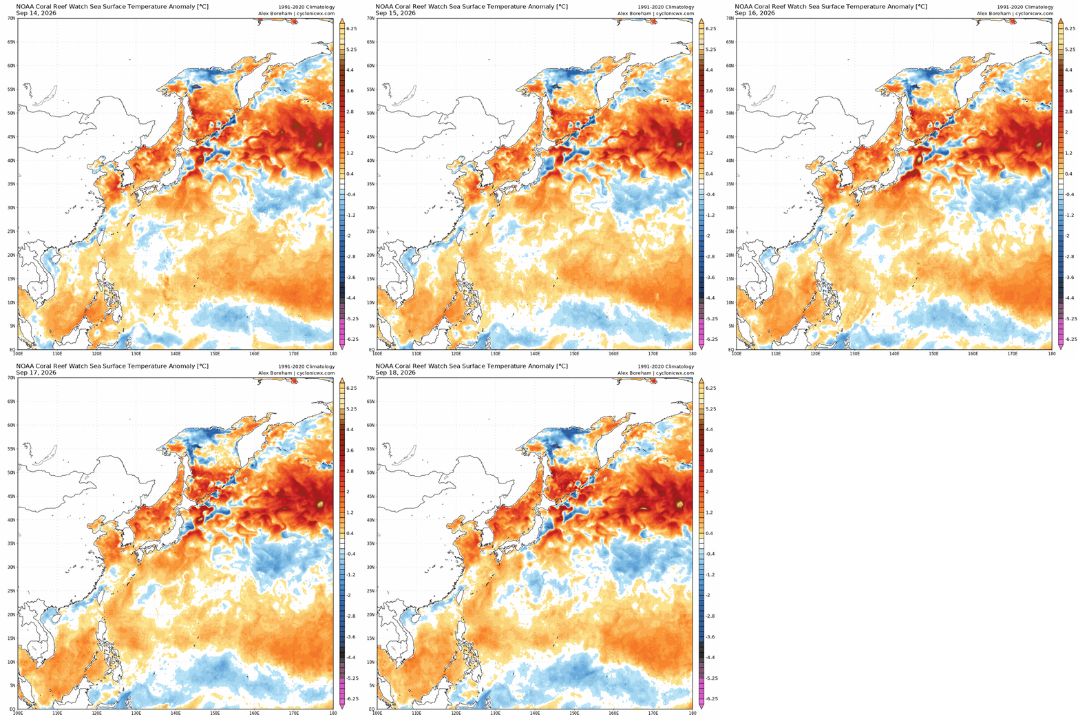
-
The Orioles outfield is a joke right now. C Franklin L Taveras R Hinds And yet Elias and Albernaz are both back next year.
-
 sildenafil 50 mg price: GetBelvion - viagra canada
 -
Not yet Tropical Depression Six Discussion Number 2 NWS National Hurricane Center Miami FL AL062026 900 PM GMT Sat Sep 19 2026 A new burst of convection has formed over the depression, that mostly covers the center of the system. However, the bulk of the convection is still on the northern side of the cyclone at this time, implying that some wind shear is still affecting it. The most recent TAFB Dvorak fix was T2.0/30 kt, which is the same as the previous cycle. Therefore, the initial intensity remains at 30 kt for this advisory. Tropical Depression Six is still moving slowly, but has started to show a bit more motion towards the north-northeast. The cyclone should move more northeastward for roughly the next 36 h as a trough to the north weakens a low- to mid-level ridge to the northeast. Following this, at around 48 h, the ridge should build back towards the west, which in turn will force the cyclone to move southwestward for the rest of the forecast period. The current NHC forecast track is very similar to the previous forecast track with small adjustments to the track and speed, and remains in good agreement with HCCA and GDMI. The cyclone should move into a slightly more favorable environment, between two areas of intense shear, and so there a good chance for intensification to occur for the next day or so. After 36 h, the system should move into an area of higher shear as the previously mentioned trough moves closer. This should lead to a gradual weakening of the system. The depression is expected to become a post-tropical remnant low around 72 h, and then dissipate around 120 h. There is still some uncertainty in the forecast of when the cyclone will become post-tropical and then dissipate, as both could possibly occur sooner than what is currently forecast. The new NHC intensity forecast is still in the middle of the guidance envelope, and is closely align with HCCA and just under GDMI for peak intensity. FORECAST POSITIONS AND MAX WINDS INIT 19/2100Z 32.9N 33.4W 30 KT 35 MPH 12H 20/0600Z 33.3N 33.2W 40 KT 45 MPH 24H 20/1800Z 33.8N 32.9W 45 KT 50 MPH 36H 21/0600Z 33.7N 32.4W 40 KT 45 MPH 48H 21/1800Z 32.9N 32.5W 35 KT 40 MPH 60H 22/0600Z 31.7N 33.4W 30 KT 35 MPH 72H 22/1800Z 30.5N 34.8W 25 KT 30 MPH...POST-TROP/REMNT LOW 96H 23/1800Z 28.6N 38.3W 20 KT 25 MPH...POST-TROP/REMNT LOW 120H 24/1800Z...DISSIPATED $$ Forecaster Katz/Berg
-
Got the seed down so just need Ma Nature to water it in
-
I'm wearing a hoodie
-
Maybe already posted somewhere in this thread/forum, but if not, Nam, Href, and Sref are gone as of 10/6.
-
Albernaz back for 2027 per Elias... Mancini to retire https://www.espn.com/mlb/story/_/id/49982125/orioles-activate-ex-closer-felix-bautista-trey-mancini-retires Mike Elias, Baltimore's president of baseball operations, said Saturday that Albernaz would return in 2027. The Orioles are 75-79 in Albernaz's first season and began the day three games out of an American League wild-card spot. "It's a great vote of confidence," Albernaz said. "Obviously, this season hasn't gone the way I wanted it by any stretch, by how the players wanted the season to go, how the front office, how the fanbase. ... That's something I wear pretty heavily because of the seat I'm in and I don't take that lightly." In addition, Trey Mancini signed a one-day contract to retire with the Orioles, the franchise he played for during the bulk of his eight-year career in the majors.