
All Activity
- Past hour
-
37 degrees this morning. First time it hit the 30’s this season.
-

2026-2027 Fall/Winter Mountain Thread
Buckethead replied to BlueRidgeFolklore's topic in Southeastern States
Currently 49 with fog and drizzle in Wolf. Sent from my SM-S948U using Tapatalk -

Strong Nor'Easter/Hybrid Storm Late September 2026
TriPol replied to Rjay's topic in New York City Metro
The 06Z GFS is broadly similar to the 00Z run, but there are several important differences in timing, intensity and the eventual track of the coastal storm. The first notable change is that the 06Z GFS develops and deepens the cyclone somewhat faster. By Friday morning, the 06Z run has the low near 997 mb, roughly a couple of millibars deeper than the 00Z run at the same valid time. Through Friday night and early Saturday, that difference gradually shrinks. By Saturday morning and afternoon, both runs are clustered near 991 to 993 mb, showing remarkably good agreement on the storm's peak intensity. The larger difference involves what happens after the cyclone reaches its mature stage. The 00Z GFS showed a clearer and more sustained westward retrograde, bringing the low back toward the New York and New Jersey coastline after it stalled offshore. The 06Z GFS still stalls the cyclone southeast of Long Island, but the westward motion is less pronounced. Instead, the system largely meanders near the 70°W longitude corridor while gradually weakening. The 06Z run also produces a particularly intense northwest-side precipitation band Saturday, placing Long Island, New York City, northern New Jersey and southern New England beneath a prolonged rain shield. Overall, the 06Z run does not represent a major departure from 00Z. Both depict a deep coastal cyclone that moves north, stalls south of New England, and slowly weakens. The principal uncertainty remains how far west the trapped circulation ultimately drifts. -

October Comes Early: Late September Multi-Hazard Hybrid Storm
kdxken replied to WxWatcher007's topic in New England
-
Yep, I really hate the shorter daylight.
-
Strong Nor'Easter/Hybrid Storm Late September 2026
TriPol replied to Rjay's topic in New York City Metro
They're waiting for the GFS to decide what it wants to do. If the 12z GFS does what the 0z GFS did, then they'll change. -

2026 Atlantic Hurricane Season
Windspeed replied to Stormchaserchuck1's topic in Tropical Headquarters
Not only has Fay come back from the dead, for now, at least, a small ULAC has positoned right over top of the system. Shear has dropped significantly. The TC is embedded in a rather dry environment. As the NHC noted in their discussion, this may prevent any significant intensification. Despite the less than ideal moisture environment, convection has managed to blossom this morning, however. Might we get a surprise? It has an established vortex and 36-48 hours to play with before shear reinvades. -

October Comes Early: Late September Multi-Hazard Hybrid Storm
vortex95 replied to WxWatcher007's topic in New England
No, the biggest question is if NHC will ever acknowledge this thing as potential ST or T transition and name it operationally if it does what some models are showing! -
Thank you for shifting attention to the mid-Atlantic coming powerful high impact event--interrupting lives. I am in agreement and it's been on the modeling from the EC EFS for several days (earlier posts own phase etc). One note I think everyone with interest in GFS suite modeling vs EC suite should monitor for eventual outcomes. While nothing is yet slam-dunk, I do believe it is now apparent the GFS suite has been wayward east (as the CMC GEPS) for several days. For now, unless NHC can get us a something to look at via RAL, we're on our own. IMO. I think by 4PM today the weather sensitive groups along the mid-Atlantic-SNE should be looking for mitigating risks including alternate plans.
-
October Comes Early: Late September Multi-Hazard Hybrid Storm
vortex95 replied to WxWatcher007's topic in New England
Notice how tight pres gradient is near the center and it wanes outside of that? That's tropical structure. -

October Comes Early: Late September Multi-Hazard Hybrid Storm
CoastalWx replied to WxWatcher007's topic in New England
I think so. Consensus seems like a loop south of BID, maybe west to south of ern LI and then lifting NE from there. Seems like biggest question is angle or approach before loop. That will dictate best winds and potential coastal flooding. - Today
-
 canadian pharmacy 365: СanAm Cross Care - canadian pharmacy checker
 -

October Comes Early: Late September Multi-Hazard Hybrid Storm
ineedsnow replied to WxWatcher007's topic in New England
980mb at hr72 that would be fun -
October Comes Early: Late September Multi-Hazard Hybrid Storm
ineedsnow replied to WxWatcher007's topic in New England
Hopefully the RRFS can score a win for the first time ever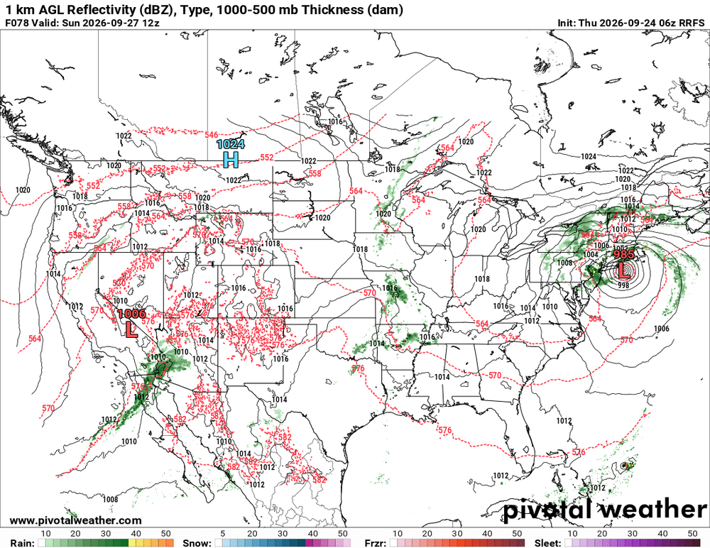
-
October Comes Early: Late September Multi-Hazard Hybrid Storm
vortex95 replied to WxWatcher007's topic in New England
Yes, inconsistent operational TC forecasting here. The fact a system is close to land or not should be irrelevant. The atmosphere does not abide by our rules and policies, it does what it does, and we need to do things according to it! And as noted, people in the field notice these things, and are valid concerns/complaints. And w/ social media these days, that can result in a PR disaster. You can't brush such things under the rug anymore hoping ppl will not notice. And in this case, it is not a low probability event. Some models are showing it clearly, and when you combine that w/ practical empirical fcst skill/experience? -

October Comes Early: Late September Multi-Hazard Hybrid Storm
Spaizzo replied to WxWatcher007's topic in New England
I am more of a winter lurker. I came on because my husband said we are getting a little rain and some gusts of wind. It’s no big deal here only the cape. I just saw a post from a local TV Met that intrigued me enough to come back to check here for the bigger picture. Super storm sandy, remnants of ida, Irene, flash flooding here in Seymour and Oxford over a trivial rain event are engrained in my memory and how many were caught off guard. While sandy people prepped more for wind rather than flooding. One thing I’ve learned is people don’t believe the forecasts unless it’s labeled something. Here in New England flash flooding is often warned about rarely happens in a devastating ways. They’re warned but people just sort of give it a meh we always get those nothings going to happen. Meh those weather guys are always wrong. What they don’t do is listen and understand the chance is there. I have to say I’ve seen more downplaying of this more than hype on social media. . -

October Comes Early: Late September Multi-Hazard Hybrid Storm
DirtySnowDen replied to WxWatcher007's topic in New England
You can see the skew-Ts for yourself, this things is getting funneled in cold air from aloft, as its surface low is feeding off a near-record or (record?) warm Atlantic. -
Septorcher 2026 Discussion - Endless Summer
ineedsnow replied to Damage In Tolland's topic in New England
Congrats central and Northern New England.thumb.png.5ff96a1642ea8180ba9d0125e2c11dc5.png)
-

Strong Nor'Easter/Hybrid Storm Late September 2026
nycwinter replied to Rjay's topic in New York City Metro
upton continues to downplay the threat for the nyc area.. -
October Comes Early: Late September Multi-Hazard Hybrid Storm
ineedsnow replied to WxWatcher007's topic in New England
After looking at all the 0z models it seems we got a good storm on the way! About damn time this boring weather ends!! -
October Comes Early: Late September Multi-Hazard Hybrid Storm
vortex95 replied to WxWatcher007's topic in New England
On the tropical forum, it was pointed out the high 1000-500 thk. The initial low pressure center currently is S of the 576 thk line, and it wraps up and pools this value into a discrete closed contour! That's what Sandy had offshore E of ORF the day of landfall. 576+ is more than enough for a solid warm core that is not shallow (500 and below). -

Strong Nor'Easter/Hybrid Storm Late September 2026
wthrmn654 replied to Rjay's topic in New York City Metro
No change from Upton , already passed there usual time when they change/ issue things -
2026 Atlantic Hurricane Season
vortex95 replied to Stormchaserchuck1's topic in Tropical Headquarters
I forgot to check the 1000-500 thickness. Good catch! 576+ is more than enough for a solid warm color that is not shallow (500 and below). The initial low pressure center currently is S of the 576 thk line, and it wrap up and pools this value into a discrete closed contour! That's what Sandy had offshore E of ORF the day of landfall. -

Strong Nor'Easter/Hybrid Storm Late September 2026
jm1220 replied to Rjay's topic in New York City Metro
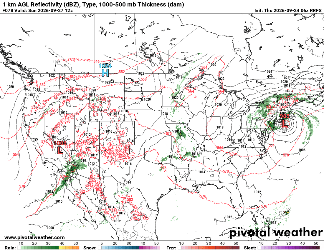
Big time beach erosion and flood risk with a track like that. -
best pharmacy in india: GenIndusPharma - buy generic medicines online india





.png.25b159318c0ee5a613cbb31bd00b7104.png)

