All Activity
- Past hour
-

2025-2026 ENSO
40/70 Benchmark replied to 40/70 Benchmark's topic in Weather Forecasting and Discussion
2017-2018 was my last good winter. -

July 2025 Discussion-OBS - seasonable summer variability
SACRUS replied to wdrag's topic in New York City Metro
74 / 72 cloudy. Perhaps some clearing later this afternoon but not enough to extend this recent heatwave 6/28 /29 - 7/1. Storms/showers look to stay mainly in southern areas. Drier/warmer tomorrow to setup a very summery 5 -6 day stretch. 80s - low 90s in the hot spots the 3rd. Stray storms mainly north Thu evening-overnight. Fourth of July Friday is looking gorgeous 80s/70s dry nw flow, great day bbq, beach, fireworks - special! Saturday warmer 80s / low 90s in the hotter spots. Heat builds back Sun - MOn / Tue - some onshore flow keeps the heat focused or concentrated strongest inland. Overall warm-hot / humid and wetter as heights remain elevated but showers/storms pop Tue - beyond. 7/2: Clouds - scattered showers focused south 7/3 - 7/5 : Dry/ warm - clear 80s 7/6 - 7/8 : Hot / humid - strongest heat west 7/9 - beyond : Warm - hot and wetter overall (looks to have spikes of heat, showers/storms) -
0.63", heaviest rains missed north and just south
-

July 2025 Obs/Disco ... possible historic month for heat
CoastalWx replied to Typhoon Tip's topic in New England
Easy to see why the camps around here never had AC. Can’t do that anymore. Even as a kid, we had some cool mornings here when I stayed in late July. -

July 2025 Obs/Disco ... possible historic month for heat
dendrite replied to Typhoon Tip's topic in New England
60s were pretty dry too so I’m sure the low dews helped. -
July 2025 Obs/Disco ... possible historic month for heat
CoastalWx replied to Typhoon Tip's topic in New England
That’s crazy though. Even though they radiate you’d think there would be more. -

2025-2026 ENSO
Stormchaserchuck1 replied to 40/70 Benchmark's topic in Weather Forecasting and Discussion
This is what you call "random" Now of course when coupled with certain ENSO phases, it becomes predictive at the cold season Stratosphere.. as high as a 75% chance. But that doesn't make it to the surface as much as is believed, typically. The Northeast is actually above average temps in warm Stratosphere cold seasons as a broad based thing. -
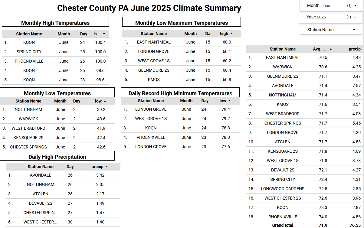
Here in June in Chester County PA finished with an average temperature across the county of 71.9 degrees. This was the 26th warmest June since records began in 1893. Of note 19 of the 25 warmest June months occurred prior to 1980. Below is the climate summary by Station for June 2025.
-

E PA/NJ/DE Summer 2025 Obs/Discussion
ChescoWx replied to Hurricane Agnes's topic in Philadelphia Region
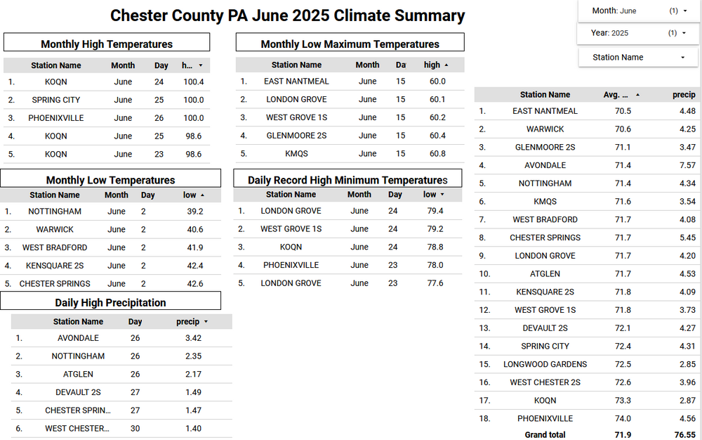
Here in June in Chester County PA finished with an average temperature across the county of 71.9 degrees. This was the 26th warmest June since records began in 1893. Of note 19 of the 25 warmest June months occurred prior to 1980. Below is the climate summary by Station for June 2025.
-
11-12 was a prime example of certain folks using the -QBO = big high latitude (AO/NAO) blocking….cold/snowy winter broad brush. I remember many winter outlooks that went cold and snowy for the east that fall based in very large part to the -QBO, only to colossally fail
-
2025-2026 ENSO
Stormchaserchuck1 replied to 40/70 Benchmark's topic in Weather Forecasting and Discussion
Me too lol. Since returning from California in Jan 2017, the most I've seen in a year is 15", and my average is 25-30". The biggest storm was on Nov 15, 2018 at 5.5". And it didn't snow on the West coast for 5 years, so it's been a while. Not good Edit: maybe 17-18 did better than that. I don't remember. -
2025-2026 ENSO
40/70 Benchmark replied to 40/70 Benchmark's topic in Weather Forecasting and Discussion
I would take the opposite of the last 7 years. -
2025-2026 ENSO
Stormchaserchuck1 replied to 40/70 Benchmark's topic in Weather Forecasting and Discussion
Jan 10 - Feb 6, 2025 actually had variations of a -PNA in the H5 .. so maybe that's our window, right in the middle of Winter. In the mid-atlantic, our biggest snowstorms occur with a trough in the Gulf of Alaska, so I would take the opposite of this. -

2025 Lawns & Gardens Thread. Making Lawns Great Again
tunafish replied to Damage In Tolland's topic in New England
Better nuke the yard and woods with Lesco Oak Killer. -
2025-2026 ENSO
40/70 Benchmark replied to 40/70 Benchmark's topic in Weather Forecasting and Discussion
Perhaps the most shocking fact of all is that we have continued to avoid the inevitable Long Island Express that is long overdue- -

July 2025 Discussion-OBS - seasonable summer variability
donsutherland1 replied to wdrag's topic in New York City Metro
The ranges haven't changed too much, though the summer range in Central Park has fallen a bit more than elsewhere (possibly due to the trees’ impact on highs as summer highs have decoupled from those at the surrounding sites most prominently seen with 90°/100° outcomes). But even during the summer, the coefficient of determination has barely moved (0.84 during 1961-1990 to 0.83 at present) when Central Park's range is constructed relative to those of JFK, LaGuardia, and Newark. This suggests that larger forces are responsible for the temperature range than the trees.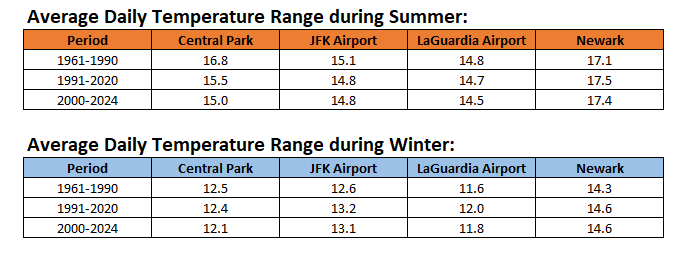
-
Yeah, we have been fortunate that there haven’t been any droughts of a similar magnitude to the 1960s to early 2000s during this much warmer climate era. But this comes at the cost of more warm season flooding events around our region. Plus much higher dew points even into New England. Last week was the highest June temperatures on record from Long Island right up into New England. But the lack of any strong drought helped keep the duration shorter. Still it was my highest temperatures since moving to just east of the KHVN ASOS site a few summers ago.
-
2025-2026 ENSO
40/70 Benchmark replied to 40/70 Benchmark's topic in Weather Forecasting and Discussion
I don't expect that to change.....goes with the Pacific cold phase tendency. -AO/NAO/PNA early and late season, with +AO/NAO/PNA sandwiched in the middle.....+AO/NAO definitely tipping the seasonal mean in that direction, but I think the -PNA portion will also win out in the mean. Just not as extreme as 2022-2023. -

July 2025 Obs/Disco ... possible historic month for heat
Torch Tiger replied to Typhoon Tip's topic in New England
Mosquito overload in NH this morning. Wild -
High yesterday 88. 1.17 rain yesterday.
-
2025-2026 ENSO
Stormchaserchuck1 replied to 40/70 Benchmark's topic in Weather Forecasting and Discussion
Feb-March has had ridiculous -PNA for an 8-year period That's >+100dm for a 2-consecutive month period for 8-consecutive years. Going back through all the maps to 1948, the number 2 greatest anomaly covering 2-months in 8-years didn't even make it to +70dm.. so we've broken that record in the maps by >140%. That's one of those things were the trend forward is so strong, I don't even think there is an evening out.. it's like, watch to see if there is a -PNA in Feb-March again next year with no major chance for +PNA without an El Nino or something in that time period. Once the coldest day of the year passes, Jan 27th, there has been a huge tendency for the last 8 years to go -pna afterward. Something to watch this year. -
2025-2026 ENSO
40/70 Benchmark replied to 40/70 Benchmark's topic in Weather Forecasting and Discussion
Yes and yes. -
2025-2026 ENSO
40/70 Benchmark replied to 40/70 Benchmark's topic in Weather Forecasting and Discussion
Yea, winter is always going to warm faster than summer because there is so much more mosture in the air during the warm season. -

July 2025 Discussion-OBS - seasonable summer variability
Dark Star replied to wdrag's topic in New York City Metro
That's because our night time lows are higher... - Today
-
July 2025 Obs/Disco ... possible historic month for heat
dendrite replied to Typhoon Tip's topic in New England
CON had 15 mins in the 1960s (60-69) of 68° or higher. 15. They’ve had 63 of them since 2018.