All Activity
- Past hour
-
Off to the races from here on out with smoke mainly gone
-
Set a new 'cool max' (but not by much) at 73.1 degrees. Old record was 73.7 from 2015, with a 74 mark in 1992 and 2004. A cloudy/cool day on light E to NE breezes. About 90 minutes of sprinkles/mist in afternoon, very foggy this am and 61.0/59.9.
-

2025-2026 ENSO
40/70 Benchmark replied to 40/70 Benchmark's topic in Weather Forecasting and Discussion
You would be suprised how many meteorologists are relatively useless on a seasonal level. -
The sun has lacked bite over the past week from the smoke. It almost feels like a week long partial solar eclipse.
-
It’s been a bit of a dirty ridge south of here with some E flow right down into the Mid Atlantic. The smoke has helped keep a lid on max temps as well. CON is -2.5F through 8/7. With the normals I grew up with it would’ve been -0.2F in the 1990s.
-
Goes over ern LI into RI. 6z gfs is nasty in SE areas. Of course it’s fun to look at.
-
Actually got to 57 this morning. Lowest was 56.4 last weekend so definitely notable. Luckily that’s gone now.
-
Well played sir.
-
GWDLT
-
How about 8
-
6z AI has monster cane near or over OBX heading north
-
You love to see it https://x.com/bam_weather/status/1953762571917328395?s=46&t=dhcbvkjmRcyBVQtDxJ3lRg
-
 57.3 my low temperature.
 -
Last summer had a couple decent TS, after 2 years with meh. So far this warm season, we had one strike within 3 miles in May but no others within 5 miles. Only 4 days with any thunder so far, lowest thru this date since we moved here in 1998. The past 2 weeks have given us 0.03" RA and the Sandy River flow is below the 10th percentile.
-
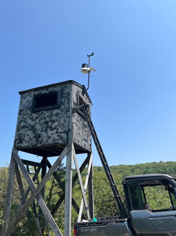
Haven’t posted in a while, but I thought this sub would be interested for future weather events, I installed a Kestrelmet 6000 cellular weather station on top of Schunnemunk Mountain. It’s at 1,450’ elevation. Should be interesting for wind gusts and elevation based temp differences in the winter! Link is below: https://ambientweather.net/share/6fLle4
-
 Might feel a little better with the westerly flow outcome honestly. I’d rather it 100/65 vs the 92/77 we have with the southerly flow. That way we maybe notch another 100 and the disgusting humidity is kept away. These 75-80 dews we get now are hideous.
 -
Hottest summer ever through October
-
Up until couple years ago, there was a 3yr stretch where we just didn't get any storms. Last summer was decent. This year, back to meh. Sent from my SM-S921U using Tapatalk
-
 57 here right now-feels great! Nice to see the big heat backing off too for next week (still hot though but 90 is better than 98)
 -
We 6z GFS
-
Man, even if there’s a bootleg cool down from Northeast winds, dews and heat come right back
-
Sell any cold front too
- Today
-
 Officially the coolest start to August since 2013 which was a nice break from the wall to wall heat since late June. Hoping the 0z Euro has a clue about the more onshore flow and the 100° heat misses to the north in Maine. But the GFS still has more westerly flow and gets the warm spots to 101° on Wednesday. We are one of the parts of the country where a small shift to more southerly flow can make the difference between 90s and low 100s. Time Series Summary for NEWARK LIBERTY INTL AP, NJ August 1-7 Average Temperature Click column heading to sort ascending, click again to sort descending. 2025-08-07 74.5 1 2024-08-07 81.7 0 2023-08-07 75.6 0 2022-08-07 83.1 0 2021-08-07 75.6 0 2020-08-07 78.7 0 2019-08-07 77.9 0 2018-08-07 82.2 0 2017-08-07 74.9 0 2016-08-07 75.8 0 2015-08-07 79.1 0 2014-08-07 75.9 0 2013-08-07 73.2 0 2012-08-07 80.4 0 2011-08-07 80.6 0 2010-08-07 79.9 0
 -
I have a feeling some others, won't be so optimistic about the heat. But i'm sure they'll sweat through it.
-
Down to 54 here-feels like fall. Unfortunately short lived.


