All Activity
- Past hour
-

Hurricane Erin: 105 MPH - 945 mb - NNE @ 17
NorthHillsWx replied to BarryStantonGBP's topic in Tropical Headquarters
Erin now has an ACE of 30 with at least 24 hours left as a hurricane -
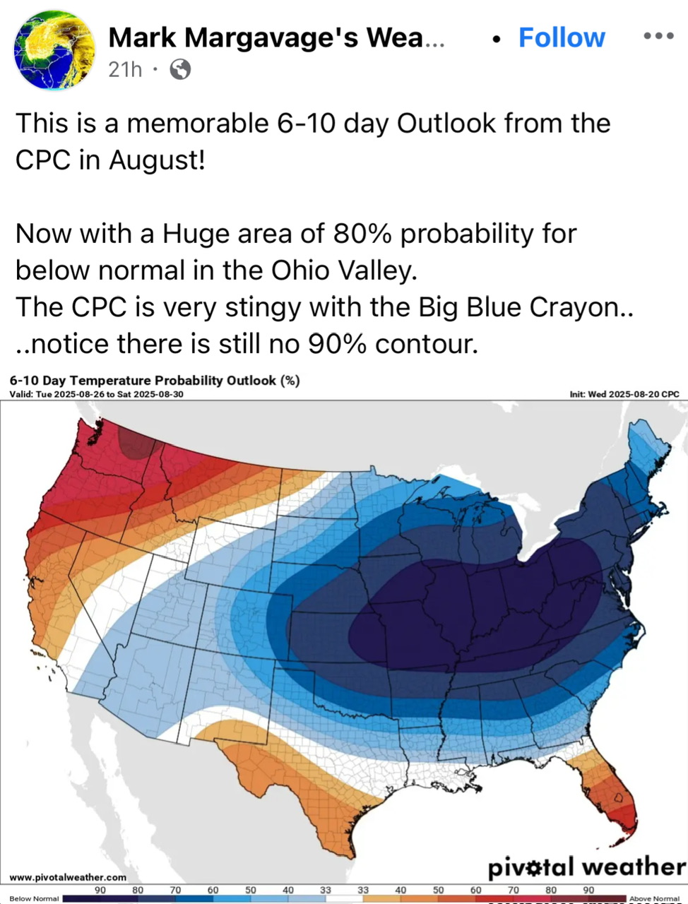
 If we eliminate any correction for urban heat island, the top ten summer averages run closer to Don's top ten. The top contenders would be 01_ 2010 _ 25.44 C __ 01 Don's list 02_ 1966 _ 25.18 C __ 02 Don 03_ 2005 _ 25.04 C __ 04_ 1993 _ 24.94 C __ 03 Don 05t_ 1983 _ 24.93 C __ 05t_ 2020 _ 24.93 C __ 07_ 1949 _ 24.92 C __ 08 Don 08t_ 2016 _ 24.85 C __ 08t_ 2022 _ 24.85 C __ 10t_ 1999 _ 24.83 C __ 05 Don 10t_ 1980 _ 24.80 C __ 06 Don 10t_ 1988 _ 24.80 C __ 07 Don 13_ 2024 _ 24.78 C __ 14_ 1995 _ 24.74 C __ 04 Don 15_ 1944 _ 24.72 C __ 16t_1943 _ 24.63 C __ 16t_2015 _ 24.63 C __ 18_ 1991 _ 24.61 C __ 19_ 1908 _ 24.56 C __ 20_ 1994 _ 24.55 C __ 10 Don 21_ 1973 _ 24.52 C __ 22_ 1876 _ 24.46 C __ 23t_1955 _ 24.43 C __ 23t_2002 _ 24.43 C __ 25_ 1971 _ 24.42 C __ 26t_1906 _ 24.41 C __ 26t_2011 _ 24.41 C __ 09 Don 28_ 2021 _ 24.41 C __ 29_ 1939 _ 24.39 C __ 30_ 1981 _ 24.35 C __ 31_ 2018 _ 24.33 C __ 32_ 1953 _ 24.29 C __ 33_ 2013 _ 24.28 C __ This summer will finish somewhere near 30th. 1953 would move up several spots if we took June 4 to Sep 3. As I understand how Don constructed his index, this list basically tells you how well various summers converted their temperature regime to noteworthy hot days. More recent years all fail because their average warmth is based largely on overnight low performance combined with a steady unspectacular heat. If Don has a few minutes to spare, perhaps he could fill in the ranks of the other years above in his index.
 -
Tim Kent • Today https://www.surfline.com/surf-report/rambler-road/5842041f4e65fad6a7708b60?referral=msw&view=table https://northwildwood.com/north-wildwood-surf-cams/ Solid surf approaching 2x overhead+. Winds are unfavorable locally and most breaks are overloaded. Solid well overhead surf this morning with onshore NE winds and trashed conditions. Only doable at the sheltered/novelty spots. The big issue is that it looks like we'll see strong onshore NE winds throughout the day, meaning conditions will be choppy and very challenging. A expert only day anyway, and most breaks won't be worth the risk/reward. UPDATE: OBX, NJ See Erin’s Windy Side https://forecast.weather.gov/product.php?site=PHI&issuedby=PHI&product=AFD&format=CI&version=1&glossary=1&highlight=off MARINE... Tropical Storm Warnings are in effect for the waters offshore Manasquan Inlet to Fenwick Island through tonight with a Gale Warning in effect for the waters offshore Sandy Hook to Manasquan Inlet through tonight. For the lower Delaware Bay, a Gale Warning is in effect through midnight tonight. For the upper Delaware Bay, a Small Craft Advisory is in effect through tonight. Northeast winds continue to steadily increase today as Hurricane Erin approaches with sustained winds between 25-35 kt expected. Wind gusts upwards of 40-45 kt are expected on the Atlantic coastal waters with gusts upwards of 30-40 kt expected on the Delaware Bay before gradually diminishing overnight. Occasional showers possible across all waters which may cause locally higher gusts. Seas of 8-12 feet this morning will steadily build up to 12-17 feet this afternoon before gradually beginning to abate tonight for the Atlantic coastal waters. Rough and choppy waters are expected on the Delaware Bay.
-
 I think the cool departures will be greater this week vs next with a few >-10 this week yesterday.today.
 -
1.71", 2.06" for the month.
-
@CoastalWx

-
Not deep summer, but it is deep blue.
-
1.48” is the total here.
-

Mountain West Discussion
mayjawintastawm replied to mayjawintastawm's topic in Central/Western States
Will be interesting to see what happens with this pattern change. Over the last 60 days we've had 0.34" of rain. Ground moisture in non-irrigated spots is nonexistent. 40+ year old trees in the neighborhood are very stressed and some are dying. -
 It was actually good here, but driving north up 287 for work into NY, the color north of route 80 was amazing. I tried to take pics while driving, this was the best I could get. Going 80 and taking pics not recommended, but lots of yellow, orange and red.
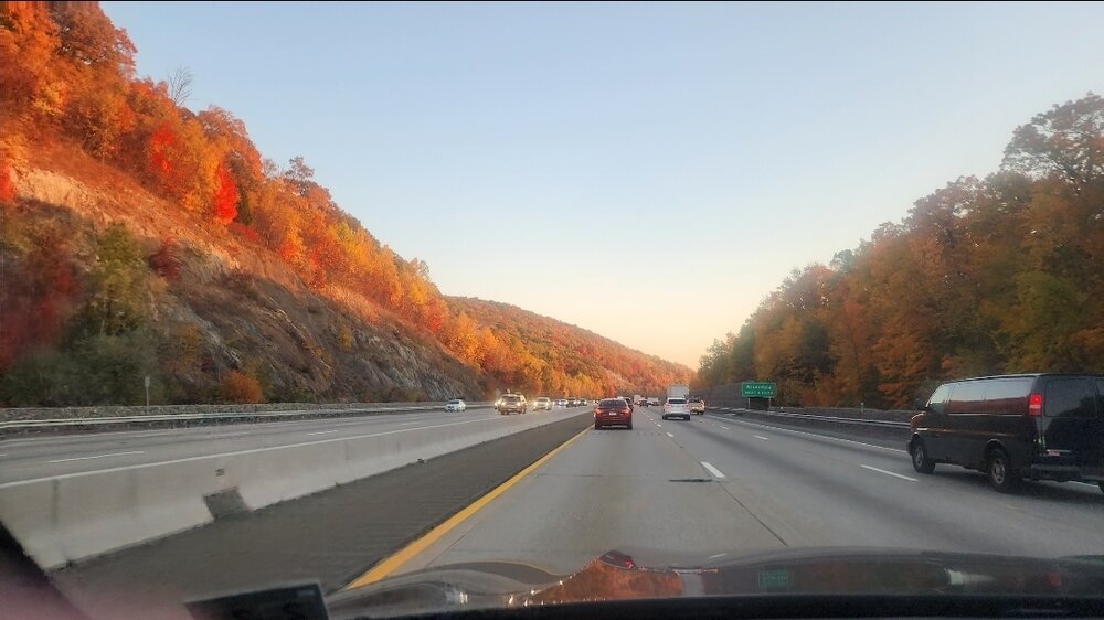
-

INVEST 90L: Central Tropical Atlantic (50/70)
BarryStantonGBP replied to BarryStantonGBP's topic in Tropical Headquarters
Thoughts Near the Leeward Islands in the Tropical Atlantic (AL90): An area of disorganized showers and thunderstorms associated with a tropical wave is located a few hundred miles east of the Leeward Islands. Environmental conditions appear conducive for further development of this system, and a tropical depression is likely to form this weekend while it moves near or to the north of the northern Leeward Islands. * Formation chance through 48 hours...medium..50 percent. * Formation chance through 7 days...high...70 percent. -
INVEST 99L FORMED: (40/40)
BarryStantonGBP replied to BarryStantonGBP's topic in Tropical Headquarters
NHS KEPT IT AT 40/40 Eastern Tropical Atlantic (AL99):Showers and thunderstorms associated with a tropical wave located several hundred miles west-southwest of the Cabo Verde Islands have changed little in organization since earlier today. Environmental conditions appear marginally favorable for additional development over the next day or so while the system moves generally westward at 10 to 15 mph, and a short-lived tropical depression could form. In a couple of days, environmental conditions are expected to become unfavorable for further development.* Formation chance through 48 hours...medium...40 percent.* Formation chance through 7 days...medium...40 percent. -
I had a house on 14th Street North. Wildwood would go down there when I was 5 years old. It was always so much fun and still do now but don't have a home there any longer. I can imagine the areas that flood are probably in pretty bad shape right now thinking West Wildwood and that bridge area and back Bay areas. The video camera at 15th and surf avenue at the lifeguard station shows a pretty wild situation with huge seas, very choppy conditions and high winds. Was a crummy week at Dewey but looking forward to some more day trips in September to the beach as the ocean remains warm and there should be some days with offshore winds for good surfing.
-
 Some people said that for some places but other locations were abysmal. I know because I saw the garbage color myself.
 -
 the sun is coming out and my allergies are GONE!
 -

2025 Spring/Summer Mountain Thread
Met1985 replied to Maggie Valley Steve's topic in Southeastern States
Pouring the rain again today. Storming all around. -
hurray my allergies are finally GONE-- I think it's drying out and I even saw a peek of sunshine!
-
Occasional Thoughts on Climate Change
LibertyBell replied to donsutherland1's topic in Climate Change
it goes along with my intuition of rising temperatures linked to more violence and wars. we see this all the time in the summer, higher temperatures closely connected to gun violence. -
73.3/37 More dews in the 30s this month than the 70s
-
67 here. Making beef jerky on the smoker. Picked a good day for it.
-
Good luck with the flies
-
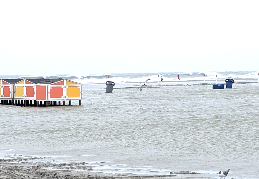
Total overwash in wildwood crest NJ in a pretty stiff breeze. Low tide now, seagulls be like "SCREEEE!" flying by. Will be a fun high tide later. The ocean is ROUGH. I've never seen the horizon look so choppy here (been coming for 35+ years)
-
Looks like some drier air is slowly making it's way into the region as Erin pulls away...maybe we can get some breaks in the clouds by early evening. 4 days straight of this...it's time for a pattern flip.
-

Hurricane Erin: 105 MPH - 945 mb - NNE @ 17
Paleocene replied to BarryStantonGBP's topic in Tropical Headquarters
Total overwash in wildwood crest NJ in a pretty stiff breeze. Low tide now, seagulls be like "SCREEEE!" flying by. Will be a fun high tide later. The ocean is ROUGH. I've never seen the horizon look so choppy here (been coming for 35+ years)
-
 Supposed to hit 74 later but still sitting at 65