All Activity
- Past hour
-
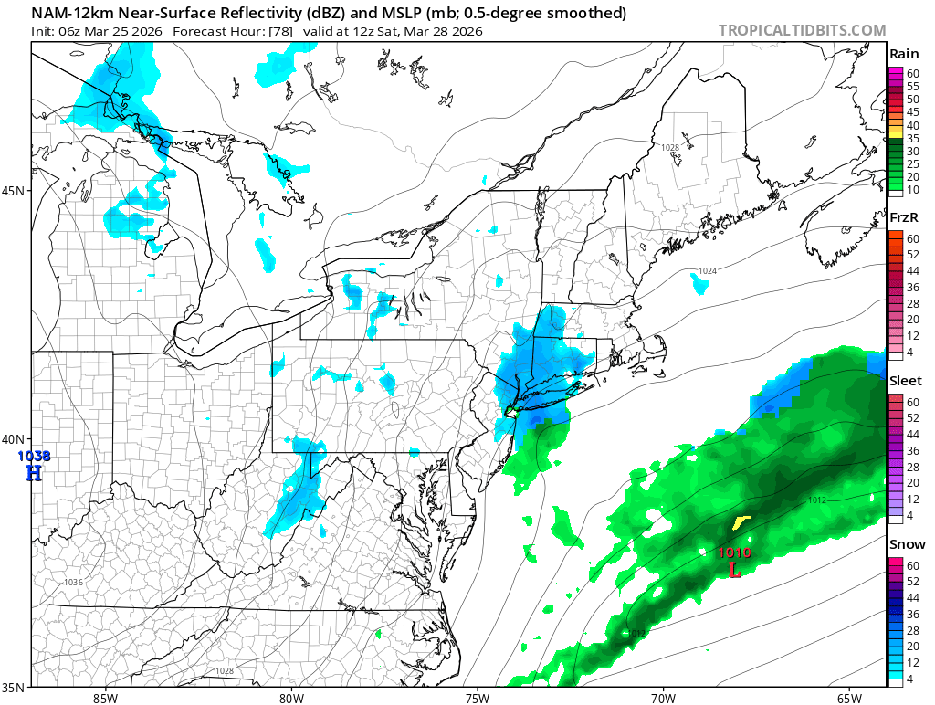
Rgem also showing. Would be nice to see flakes.
-
Big ridge shifting to the EC, lets see how this progresses, ensures and ultimately how warm can push into the city NE 3/30 - 4/9 looks above to much above normal.
-
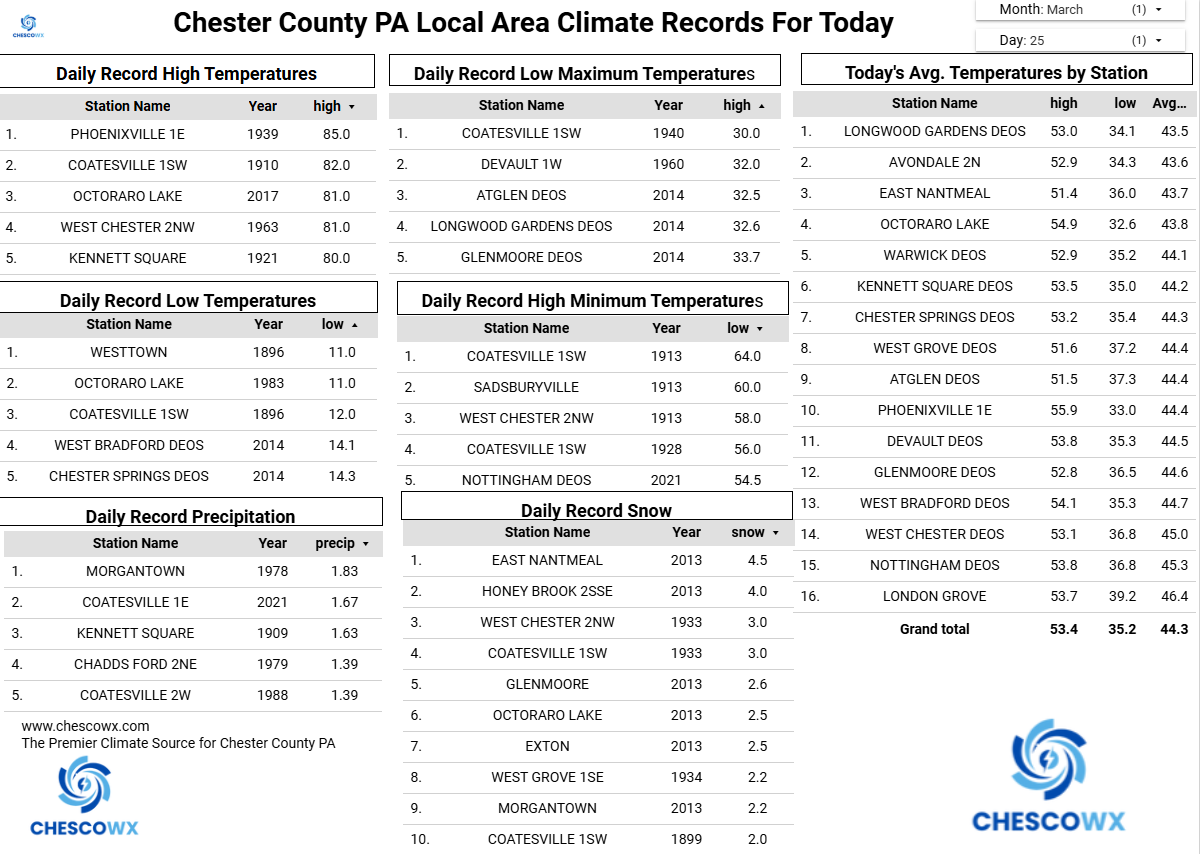
Records: Highs: EWR: 79 (1963) NYC: 79 (1963) LGA: 77 (1963) JFK: 68 (2016) Lows: EWR: 18 !956) NYC: 13 (1878) LGA: 18 (1940) JFK: 23 (2014) Historical: 1843 - A second great snowstorm hit the northeastern U.S. The storm produced snow from Maine all the way to the Gulf of Mexico. Natchez MS received three inches of snow, and up to 15 inches buried eastern Tennessee. Coastal Maine received 204 inches of snow that winter. (David Ludlum) 1901: More than 20 people were killed by an estimated F3 tornado that moved across parts of Birmingham, Alabama. The twister cut a 15-mile path from the south side of the city to Avondale and Irondale. 1914 - Society Hill, SC, was buried under 18 inches of snow, establishing a state record. (Sandra and TI Richard Sanders - 1987) 1934 - A spring storm produced 21 inches of snow at Amarillo TX in 24 hours. However, much of the snow melted as it fell, and as a result, the snow cover was never any deeper than 4.5 inches. (David Ludlum) 1935: Suffocating dust storms frequently occurred in southeast Colorado between the 12th and the 25th of the month. Six people died, and many livestock starved or suffocated. Up to six feet of dust covered the ground. Schools were closed, and tenants deserted many rural homes. 1948 - For the second time in less than a week airplanes were destroyed by a tornado at Tinker AFB in Oklahoma City OK. A March 20th tornado destroyed fifty planes at Tinker AFB causing more than ten million dollars damage, and the March 25th tornado destroyed another thirty-five planes causing six million dollars damage. The first tornado struck without warning, and caused more damage than any previous tornado in the state of Oklahoma. The second tornado was predicted by Fawbush and Miller of the United States Air Force, and their accurate tornado forecast ushered in the modern era of severe weather forecasting. (The Weather Channel) (Storm Data) (The National Severe Storms Forecast Center) 1975 - The town of Sandberg reported a wind gust to 101 mph, a record for the state of California. (The Weather Channel) 1987 - Heavy rain left rivers and streams swollen in Kansas and Nebraska, causing considerable crop damage due to flooding of agricultural areas. The Saline River near Wilson Reservoir in central Kansas reached its highest level since 1951. March rainfall at Grand Island NE exceeded their previous record of 5.57 inches. (The National Weather Summary) (Storm Data) 1988 - An early season heat wave prevailed in the southwestern U.S. The high of 93 degrees at Tucson, AZ, was a new record for March. Windy conditions prevailed across the central and eastern U.S. Winds gusted to 60 mph at Minneapolis MN, and reached 120 mph atop Rendezvous Peak WY. (The National Weather Summary) (Storm Data) 1989 - A Pacific storm brought wet weather to much of the western third of the country, with heavy snow in some of the higher elevations. La Porte CA was drenched with 3.56 inches of rain in 24 hours. Up to 24 inches of snow blanketed the Sierra Nevada Range. (The National Weather Summary) (Storm Data) 1990 - Temperatures dipped below zero in the Northern Rocky Mountain Region. Hardin MT was the cold spot in the nation with a morning low of 10 degrees below zero. Freezing drizzle was reported in the Southern Plains Region, with afternoon highs only in the 30s from the Southern High Plains to Missouri and Arkansas. (The National Weather Summary) 1992: Hailstones up to four inches in diameter resulted in more than $60 million in damage in Orlando, Florida. This storm is still the costliest Florida hailstorm on record. 1993: A severe thunderstorm produced hailstones up to 2 inches in diameter across parts of Austin, TX, resulting in the worst and costliest hailstorm in the city's history. An estimated $75 million dollars in damage was done to cars, roofs, skylights, greenhouses, and vegetation. 60 people were injured by the hail as they scrambled to protect their vehicles and other valuables. (Ref. Wilson Wx. History) 1995: The first of three big hailstorms of the spring struck the Dallas-Fort Worth Metroplex in Texas. A severe thunderstorm moved across Dallas County, dumping hailstones up to 3 inches in diameter. Total damage reached $80 million dollars.
-

2026-2027 El Nino
bluewave replied to Stormchaserchuck1's topic in Weather Forecasting and Discussion
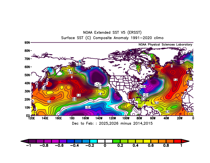
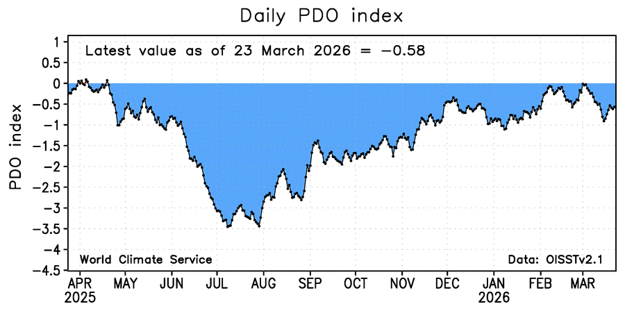
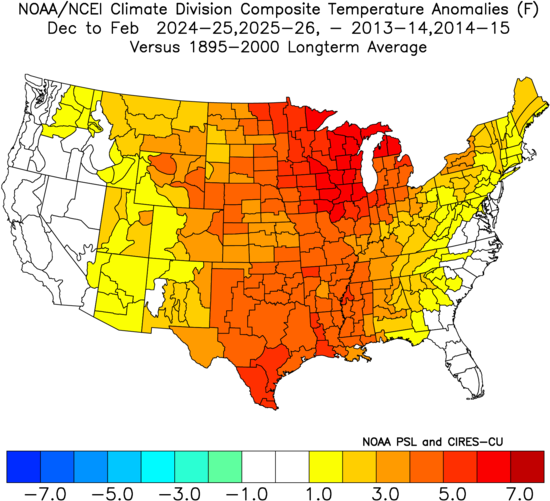
We had some good discussions on this topic over the years. My guess is that the 500 mb ridging associated with the ABNA ridge during 2024-2025 and 2025-2026 winters was effectively pulled south due to the record mid-latitude marine heatwaves across the North Pacific. So a much stronger subtropical ridge influence than 2013-2014 and 2014-2015. This lead to lower heights across the -WPO region in 2024-2025 and 2025-2026 relative to 2013-2014 and 2014-2015. So this stronger subtropical ridge influence may have also contributed to the weaker TPV in the Great Lakes and Northeast and much warmer winters than we got those years. Notice that the warm pool extending from Japan to California didn’t let the PDO index show a strongly +PDO reading even with the record SSTs off the California Coast for this time of year. This also makes it more difficult to have a one to one comparison with the PDO readings of the past that didn’t have the record mid-latitude warm pool east of Japan and south of the Aleutians.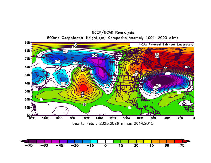
-
40 / 32 roller coaster goes up today / Thu (but mainly cloudy) with upper 60s to low 70s then down / chillier this weekend Fri / Sat before coming back up for the longer duration as we moderate and transition into a warmer to much warmer setup into the first week to 10 days of April. Next week while looking warmer might see most days cloudy with some showers before the ridge really builds over the east in the April 3 - 7 period.
-
miss south stink but better than anticipated
-
The weather channel weather app showing 80 and 83 for next Thursday and Friday here….that might be a little aggressive lol….it had 60’s last night. Probably be gone in the next few hrs anyway…thing is all over the map.
-
Hello Baseball! Go Yanks! .
-
(002).thumb.png.6e3d9d46bca5fe41aab7a74871dd8af8.png)
Central PA Spring 2026 Discussion/Obs Thread
ChescoWx replied to Voyager's topic in Upstate New York/Pennsylvania
We should be close to normal temperatures today (low to mid 50's) before a brief spike to well above normal for The Phillies Opener (upper 60's). Then back to below normal temperatures Friday through the weekend. Shower chances increase tomorrow night into Friday morning with a cold front.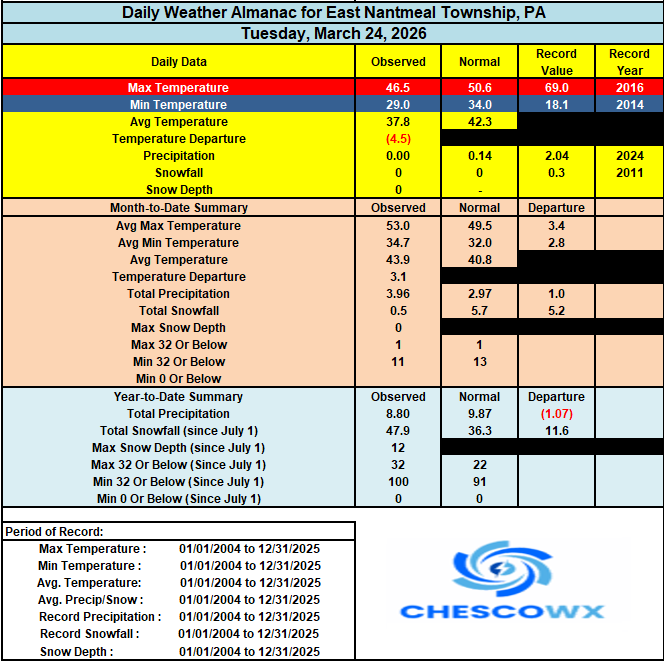

-
E PA/NJ/DE Spring 2026 Obs/Discussion
ChescoWx replied to PhiEaglesfan712's topic in Philadelphia Region
We should be close to normal temperatures today (low to mid 50's) before a brief spike to well above normal for The Phillies Opener (upper 60's). Then back to below normal temperatures Friday through the weekend. Shower chances increase tomorrow night into Friday morning with a cold front.
-
-
The coming winter is going to be heavily influenced by how potent El Nino becomes, and it's orientation.
-

2025-2026 ENSO
40/70 Benchmark replied to 40/70 Benchmark's topic in Weather Forecasting and Discussion
Yea, I missed on March this year, however, I did mention in my outlook last fall that the risk was warmer because it was dependent on a successful SSW....and obviously the can got kicked. This actually helped my DM aggregate seasonal call because I'm too warm. -
the team at klot crushing it as usual
-
any report from Jan 26-27, 2015? @snywx as well
-
Areas like the CT Shoreline have been nearly 10° lower for the average highs compared to NJ this month with the backdoor pattern. Coastal areas are normally colder this time of year. But the stalling warm fronts near NYC have enhanced the gradient. Monthly Data for March 2026 for Upton NY NWS CWA Click column heading to sort ascending, click again to sort descending. NJ CALDWELL ESSEX COUNTY AP WBAN 54.8 NJ NEWARK LIBERTY INTL AP WBAN 54.4 NJ TETERBORO AIRPORT WBAN 53.9 NJ TETERBORO AIRPORT COOP 53.9 NY PORT AUTH DOWNTN MANHATTAN WALL ST HEL ICAO 53.7 NJ HARRISON COOP 52.9 NY NY CITY CENTRAL PARK WBAN 52.5 NY LAGUARDIA AIRPORT WBAN 51.8 NJ CHARLOTTEBURG RESERVOIR COOP 51.6 CT DANBURY MUNICIPAL AP WBAN 51.4 NY MONTGOMERY ORANGE COUNTY AP WBAN 51.3 NY RIVERHEAD RESEARCH FARM COOP 50.6 CT NORWICH PUBLIC UTILITY PLANT COOP 50.3 CT DANBURY COOP 50.2 NY WESTCHESTER CO AP WBAN 50.2 NY SHRUB OAK COOP 50.1 NY BAITING HOLLOW COOP 50.0 NY CENTERPORT COOP 49.8 CT MERIDEN MARKHAM MUNICIPAL AP WBAN 49.5 NY PORT JERVIS COOP 49.1 NY SYOSSET COOP 49.0 NY FARMINGDALE REPUBLIC AP WBAN 48.8 NY JFK INTERNATIONAL AIRPORT WBAN 48.7 NY ISLIP-LI MACARTHUR AP WBAN 48.3 NY ST. JAMES COOP 48.2 CT OXFORD WATERBURY WBAN 48.1 NY BRIDGEHAMPTON COOP 48.1 NY UPTON COOP - NWSFO NEW YORK COOP 47.9 NY SHIRLEY BROOKHAVEN AIRPORT WBAN 47.7 CT GUILFORD COOP 47.5 CT IGOR I SIKORSKY MEMORIAL AIRPORT WBAN 46.8 NY ORIENT POINT STATE PARK COOP 46.7 CT NEW HAVEN TWEED AP WBAN 46.6 CT GROTON NEW LONDON AP WBAN 46.0 NY CARMEL 4N COOP 45.5
-
2026-2027 El Nino
40/70 Benchmark replied to Stormchaserchuck1's topic in Weather Forecasting and Discussion
Personally, I wasn't shocked that 2024-2025 didn't produce in terms of snowfall...my forecast totals were pretty damned accurate, as they were this past season. - Today
-
2026-2027 El Nino
40/70 Benchmark replied to Stormchaserchuck1's topic in Weather Forecasting and Discussion
Well, obviously the globe has continued to warm over the past 11-12 years, but you are also neglecting to mention that winter 2024-2025 featured a strongly +WPO. This past season had a strongly -WPO, as did 2013-2014 and 2014-2015, and what do you know...the snowfall showed up. Obviously not to the extent of the 100" in 30 days like 2015, but I think we all understand that that has a very low return rate, regardless of CC. I know there was a school of thought that this +WPO regime would be permanent as a result of the warmth in the western Pacific, but this past season clearly validated those of us that have maintained that these oscillations will remain cyclical in nature. -
Inverted trough starting to show up on some models Friday night into Saturday morning.. looks a bit south and west for now though
-
2026-2027 El Nino
40/70 Benchmark replied to Stormchaserchuck1's topic in Weather Forecasting and Discussion
I don't think these are mutually exclusive. It was warm for a couple of different reasons. 1982-1983 is the only super El Nino that was a accompanied by somewhat of a -WPO, which may help to explain why it's the only one to have featured decent snowfall throughout the NE. -
2026-2027 El Nino
bluewave replied to Stormchaserchuck1's topic in Weather Forecasting and Discussion
The atmospheric response in 23-24 was a full super El Niño when viewed through the intensity and location of the 500mb ridge in North America and warmth along the Northern Tier. The troughs across the South and East along with the Aleutian low were much weaker than we typically see with stronger El Niños. It’s a similar effect to what we have seen the last two winters with the ridges becoming more expansive than 13-14 and 14-15 leading to a much smaller trough across the Great Lakes and Northeast So we didn’t get the magnitude of the cold or snow experienced during the 13-14 and 14-15 winters during 24-25 and 25-26. Goes to the shrinking Northern Hemisphere cold pool relative to similar teleconnections during the past. So metrics like ONI, RONI, and PDO need to be filtered through this newer expression of the ridges and troughs to arrive at the sensible weather. -
Try consolidating your data you will find the story matches my above analytics.
-
2026-2027 El Nino
40/70 Benchmark replied to Stormchaserchuck1's topic in Weather Forecasting and Discussion
-
Did you guys get any accumulation? Im in Florida its 80 here....