All Activity
- Past hour
-

E PA/NJ/DE Winter 2025-26 Obs/Discussion
Albedoman replied to LVblizzard's topic in Philadelphia Region
I posted this on the 12/27 Winter is going to take a brief break after this BS first of the year storm of only 1-3 inches if we are really lucky. I see no snowstorms until after the 15th and it will warm up into the upper 40's to 50's . I do think we will pay the piper for this brief warm up by Marin Luther Kings day-- seems to be the pattern the last 5 years. All I can say is the drought situation in our area is only going to worsen as the Gulf storm production is shut down for business. Believe me, dried up wells and sinkhole formation with dropping groundwater tables with waterline breaks galore will be the talk of the town in the next three weeks as the ground starts to thaw out with what little moisture is in it. The base flows of the creeks will begin to drop again too. We really need a 96 type of storm event asap. Still holding-------- - Today
-
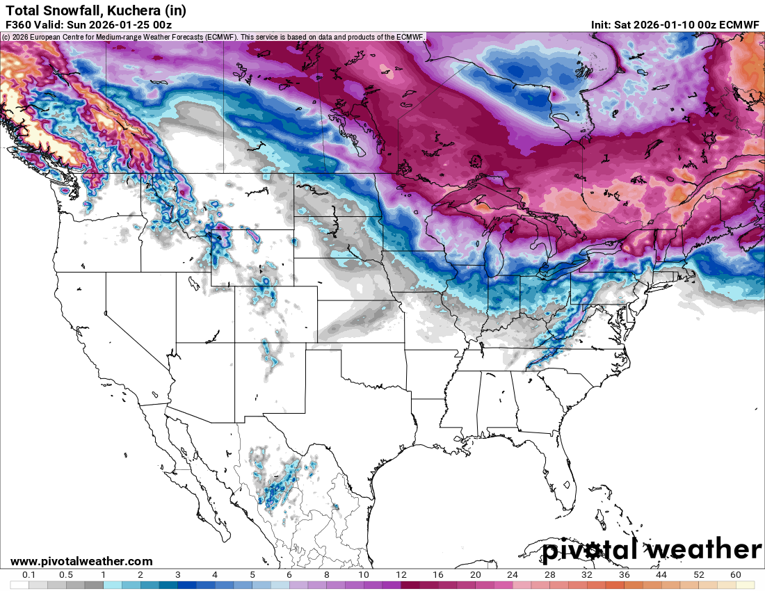
Nothing to show at all on the 0Z Euro - no snowfall and little precip after this weekend throughout the entire run
-

January 2026 Medium/Long Range Discussion
Stormchaserchuck1 replied to snowfan's topic in Mid Atlantic
Well at least we are going into a cold pattern again. PNA is changing to positive (it still hasn't been positive a single day this Winter - since Dec 1) Which is supported by the ENSO subsurface - I have found when warm water makes it east of the dateline, +PNA is more likely to occur. Kelvin waves impact the N. Pacific pattern, my theory. I think we'll have some good shots at snowstorm when the new pattern sets in, this early stuff is the thread the needle, trough is still progressive and it's unlikely that we'll get 18 hours of rain, then a blizzard on the backend with how dry the pattern has been. I think later on - last week of January and maybe going into Feb we will have some high probability snowstorm chances -
Just like last year, and probably more so, southern Canada continues to get crushed. Thanks La Niña.

-
Time is running out? Lol we got 6 to 7 days before the 1st one and 200+ hours before no 2.. we got plenty of time
-
Euro ai isn’t as bad. Thermals are iffy but idk much about how these ai models are doing with those details. Decent snow in the mountains for the 2nd one. Let’s see how the EPS looks compared to the OP.
-
Welp…certainly wouldn’t be surprising as that’s been par for the course for years now but man that would stink given how high the potential is with the overall setup.
-
70 and sunny incoming. You all thought it was gonna snow here? LOL.
-
Well another awful night of modeling and time is running out
-

January 2026 regional war/obs/disco thread
dryslot replied to Baroclinic Zone's topic in New England
TORCH! -
Euro keeps the northern stream in the way.
-
Euro went to the crapper. The northern stream is screwing us again.
-
they call the euro dr. no for a reason
-
But can already tell, Euro is a whole lot of nothing. For both.
-
You don't think he wasn't watching?
-
wtf is up with these skipping panels on the models lately. SV is particularly bad with the GFS. goes from like 210 to 252
-
WB 0Z EURO AI is closer for storm 1.
-
AH, you show up for the bad stuff
-
Geez not even close
-

January 2026 regional war/obs/disco thread
dendrite replied to Baroclinic Zone's topic in New England
50s right up to MHT
-
euro is a miss for jan 15
-
The Euro AI solution is closest to the GFS except it doesn't become a wrapped up bomb along the coast like the GFS and lacking the dynamics to draw in the colder air to produce frozen it is mainly rain right along the coast
-
Looks like the EuroAI likes the inland route for storm 2.
-
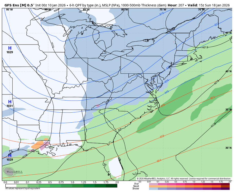
More GEFS support for Storm 2. WB 0Z GEFS.
-

E PA/NJ/DE Winter 2025-26 Obs/Discussion
Kevin Reilly replied to LVblizzard's topic in Philadelphia Region
See I told you the 18z gfs 1/9/26 would be 100% different at 0z! So, where is the cold high up north? Hmm I mean however a 983mb storm would manufacture its own cold air. Let’s go!!! Now back on the ground I need to see this at least for 6 runs on at least 3 different models before I do the snowy dance. It’s a shame the gfs is on an island by itself. I’m not buying it, but fun to look at and reminisce about winters of the past.