All Activity
- Past hour
-
Yeah, pretty strong gust just now.
-

December 2025 regional war/obs/disco thread
Typhoon Tip replied to Torch Tiger's topic in New England
This could be a great icing/mix scenario with only minor synoptic adjustment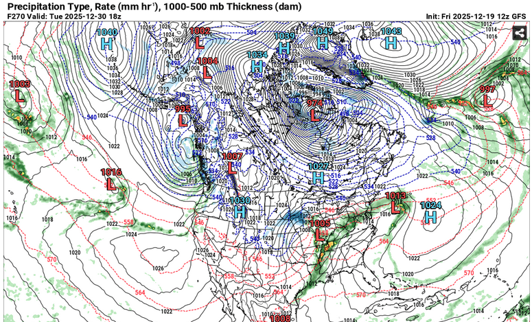
-

December 2025 regional war/obs/disco thread
TauntonBlizzard2013 replied to Torch Tiger's topic in New England
Yup. 2010 was the last one here. Im over it, we’ve manufactured ways to fail around this time over the last 15 years. Even Scott I think has managed a couple. Just an epic grinch here -

December 2025 regional war/obs/disco thread
Damage In Tolland replied to Torch Tiger's topic in New England
With NNE? I really do not . -
Next few weeks really come down to the -NAO with the Pacific the way it is. You can toggle runs from days ago today and see how extreme the solutions can differ. Look at 12z post 240.
-
typical metro weather; 6-7 inches of snow and arctic conditions, didn't last a week. all gone here, like butter melting in a skillet.....but we got some nice holiday photos.
-
Analogs have been pretty consistent showing periods leading to cold and/or stormy stretches. Jan 2022, 2009, 2000, 2011 etc. Right now boxing day is showing up lol but I'm pretty sure that's only because of the NAO and not a legit storm threat inside of 2 weeks. I agree about the dagger -pna. The persistence and duration is frustrating but it's not unusual/uncommon and it's also not a sign of extended disaster. The winter see saw in that region happens more often than not and when it flips it can be abrupt. Not the same thing as a zonal pac jet destroying hopes and dreams for months. I was never bullish on snowfall this winter but I continue to expect enough action to keep this winter out of the turd category. A single lucky storm can tip those scales as well. Can't rule that out for a couple months.
-

December 2025 regional war/obs/disco thread
SouthCoastMA replied to Torch Tiger's topic in New England
6z AI had a 1030 High in Quebec, which made it interesting for some folks further north. Did 12z look even colder? -
December 2025 regional war/obs/disco thread
Typhoon Tip replied to Torch Tiger's topic in New England
Kind of a vague SWFE look to the GFS too -
December 2025 regional war/obs/disco thread
TauntonBlizzard2013 replied to Torch Tiger's topic in New England
Epic pattern for very northern Maine on most guidance. -
There's a panic room thread too!
-
December 2025 regional war/obs/disco thread
TauntonBlizzard2013 replied to Torch Tiger's topic in New England
False. You do fine for most of the “event” you are elevated, and interior, even though SOP. Just hope it doesn’t warm up anymore, because you’ll be cooked if it does. -
Winds really died down, only a few snowpiles left. That was fast
-
The 2005/6 analog continues to look favorable to how this season is unfolding. If this continues... -Feb will not be a wall to wall torch -We will achieve near climo snowfall -We are likely out of business through at least mid January -The coldest anamolies from normal are firmly behind us for the remainder of the entire season I don't know if you draw positive or negative conclusions from this, its something for everyone. The models will continue to be volatile day to day. If anything, to my very untrained eye the pattern progression is moving pretty fast this year and perhaps suggests we wont be out of the game for weeks at a time. I sure do wish we could have timed a better pattern for the holidays. Early December cold is mostly wasted for us.
-
December 2025 regional war/obs/disco thread
SouthCoastMA replied to Torch Tiger's topic in New England
CMC did look a bit better, despite the troubles here. I wish that blocking would come back and press this south a bit more. -
I didn’t know the ENSO thread had weather influencing capabilities
-
The snow on Sun probably weakened some of the trees/power lines. The first 5” of it was paste here that clung to everything.
-
12/26 is looking warmer and warmer the last 2-3 cycles too which kind of sucks. Except Euro Skynet which is frigid.
-
Just gusted to 56kts at BOS. 18031G56
-

Pittsburgh/Western PA WINTER ‘25/‘26
colonel717 replied to Burghblizz's topic in Upstate New York/Pennsylvania
Maybe someone can pull in an inch or so. with the heavier returns to the west.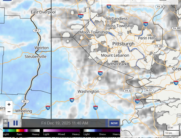
-
ENSO thread has effectively cancelled the cold shots for the last few days of the month and are advertising January to play out like it did in 2020 and 2023.
-
GOOFUS may be flirting with an entry for the digital snow thread for new year’s lol
-
Wind not too bad with the squall line. Winds offshore. Waves cleaning up 6-8’. Going surfing.
-

December 2025 regional war/obs/disco thread
Kitz Craver replied to Torch Tiger's topic in New England
I was gonna say, I checked it and thought it didn’t look too bad -
To be fair, you try to do that too with NNE fairly often. If we can trend the 23rd just a little more south/colder like skynet, then it would be pretty nice for most folks and probably slightly juicier amounts.


.thumb.jpeg.f5c6ba9d911ec96b3b124f8606aee58e.jpeg)