All Activity
- Past hour
-
Code Orange in effect today with the worst of the haze/smoke expected east of the Susky. I see little evidence of it here at work currently, however.
-
flipped back to ireland mode today, guess we need the rain def the greenest drought i can remember
-

2025-2026 ENSO
40/70 Benchmark replied to 40/70 Benchmark's topic in Weather Forecasting and Discussion
If we get well into the next decade still in a west Pac dominate -PDO, then its time to reconsider. -

2025-2026 ENSO
40/70 Benchmark replied to 40/70 Benchmark's topic in Weather Forecasting and Discussion
Like I have been saying, its not rocket science....we are rright on track for a phase switch around the turn of the decade.....the last cold phase was from 1945-1977 and that's 32 years. 32 years from the onset of this current phase in 1998 is 2030. As you can see, there have always been ENSO triggered deviations from the predominate multi decadal baseline going back throughout history. Notice also that the last major el nino during a cold phase was 1972-1973, also several years before the flip during the nadir of the second wave of the cold phase....just like 2023-2023. Its not some evoloutionary concept...its simply warmer while the same shit happens. -
FN... ALEET. Captain Summer. ALEET.
-
Friday definitely looking a bit more intriguing. Shear is very weak so this isn't a big severe setup but could be good for some local microbursts and lots of lightning.
-
Yup, that's the Low offshore. Its a rarity seeing clouds and rain coming from the east. Its strange seeing clouds move that direction around here. Looks like unsettled weather the next 5 to 7 days. Another smokey morning for me too.
-
Now we're ahead of yesterday... 77 Smoke appears to be doing the typical mid-day weakening. I'm wondering what the cause is for that. I've observed many times, these smoke bands in otherwise clear air/non-cloud contaminated skies do seem to 'thin', albeit subtly, as the mid days near. Perhaps kinetic heating of the smoke particulates, when there is higher solar insolation, then increases dispersion mechanics..
-
A nice early June day on tap with highs in the upper 70's. Skies have mellowed out with the smoke. Just a light veil. Sunrise n set have had a reddish orange sun. Still in need of precip. Early week rains were a dud here with maybe a tenth in the bucket.
-
At the moment, bright sunshine and 78 degrees here in east York. Hoping this lasts awhile before any smoke haze sets in. It was pretty hazy yesterday from here to Lewisberry.
-
They're still a big difference between the Euro and the GFS
- Today
-
damn... Saturday's still up in the air. 06z GFS kind of collapsed out of nowhere ... removing it's St Lawr. Seaway low transit. That's more like the GGEM's idea all along. Yet, it's not inundating with steady rain, like the GGEM, which showed less nor'easter low, but still fudge packs a rain band through everywhere... I'm wondering if even at this short lead ... the weak flow is causing a lot of uncertainty. The 00z Euro took a step toward more low up there, which is more of a structured warm sector thru SNE... it seems regardless, PF up there is losing Saturday to rain... check. We need to see that happen in order for the rest of us to rejoice and bathe with 70 hot virgins while he's loading the coal into the bath house steam furnace for a gay roman day spa... If we can get that symbolically arranged, all is right in the cosmos. j/k .. it may just be a frontalysis miasma day. sultry dps with light sky but little real blue... in between dark patches, with thunder audible by 11:30 off in the distance type of day.
-
Did a Dunkin run since the wife is off today. Noticed a brown haze, especially towards the southern horizon. Might have been my imagination, but I could swear the air has a slight smoke smell as well.
-
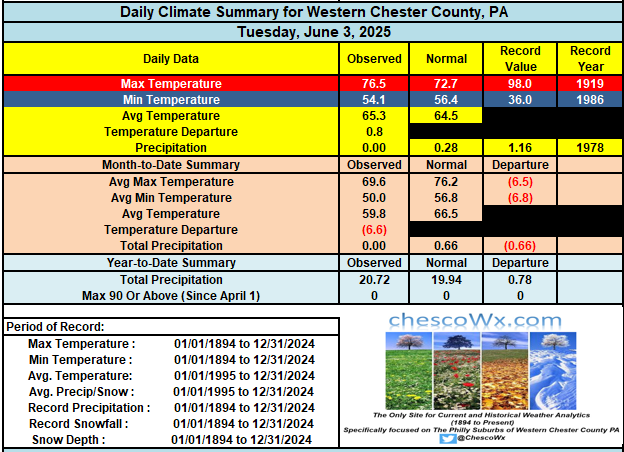
A nice couple of days on tap across the area with highs reaching up into the low 80's today and the mid 80's tomorrow. Tomorrow should be the warmest day of the week before we cool back to near normal with shower chances increasing by Friday night into Saturday.
-

E PA/NJ/DE Summer 2025 Obs/Discussion
ChescoWx replied to Hurricane Agnes's topic in Philadelphia Region
A nice couple of days on tap across the area with highs reaching up into the low 80's today and the mid 80's tomorrow. Tomorrow should be the warmest day of the week before we cool back to near normal with shower chances increasing by Friday night into Saturday. -
On the 7th I'll toss up a CF6 for the first 7 days at KEWR.... whose data seems hot to some of us but likely is not per NWS tolerances for ASOS Data. Whether we can muster 90 this Thu or Fri is doubtful to me (17C 850) and smoke aloft which I suspect is knocking off a deg or 2 on daytime max. Looking ahead 13th-20th first day of summer... I'm taking a stab here but unless compromised by sea breezes or midday showers, looks to me like a pretty long stretch of a above normal temps as Both the EPS and GEFS are developing a significant ridge somewhere between 80 and 95W...Ie Great Lakes-Upper Midwest. That should mean warming here with possible cool frontal passages, but also possible shots at 90F for at least the interior. Have a day
-
Hazy smoke slowly clearing east in NJ
-
yesterday's catching up to us from the past - ... kinda reminds me of the QM stuff about time being in both directions. Like reality explodes out of QM, as an emergence, so ... that's what makes the observation actually possible. Man, that's weird - anyway, an hour ago i cited that we were ahead of yesterday per hour::minute with temperature recovery, but had only recovered 10 - yesterday's delta per was 16... this difference was that initially, today had a 6 or so deg head start, so at the time we were ahead of yesterday. however now, we are the same as yesterday per hour:minute. So today's smoke retarded rising at a slower rate is allowing yesterday to overtake us, winning the race from the past. ... think i need to dump this coffee... so for the time being, and all other factors being equal, that leaves smoke blunting as a high confidence limiting factor. i don't think the models actually factored that in. the NAM/met machine numbers are 87-89-ish along the BDL-FIT-ASH arc ... we may still make that because the complexity of this crushingly nerdy expose is then enhanced further by the fact that machine numbers tend to be too cool on this side of the solar max anyway... so the smoke blunting give the machine numbers at an unfair competitive advantage.
-
Thank God
-
Weekend rain threat really fell apart
-
How did I go my whole life without knowing about this?
-
That is the only feature that I miss from my old house. We used that a lot.
-
on a couple of borderline nights we turned on the whole house fan-sucks the heat right out assuming the outdoors is not humid.


