All Activity
- Past hour
-

January 2026 regional war/obs/disco thread
jbenedet replied to Baroclinic Zone's topic in New England
Good point. To be sure I’m thinking most commonly 43-45 readings, for the region. a solid +10 today Dews will also be rising all day so it will compound the real feel. Legit warmth on this merit as well… Gotta get outside… -

January 2026 regional war/obs/disco thread
Typhoon Tip replied to Baroclinic Zone's topic in New England
yeah, no question there. you know there's a chance we could mix some. the NAM's grid has mid BL winds over 20 kts from the SW at 18z. might just get it done -
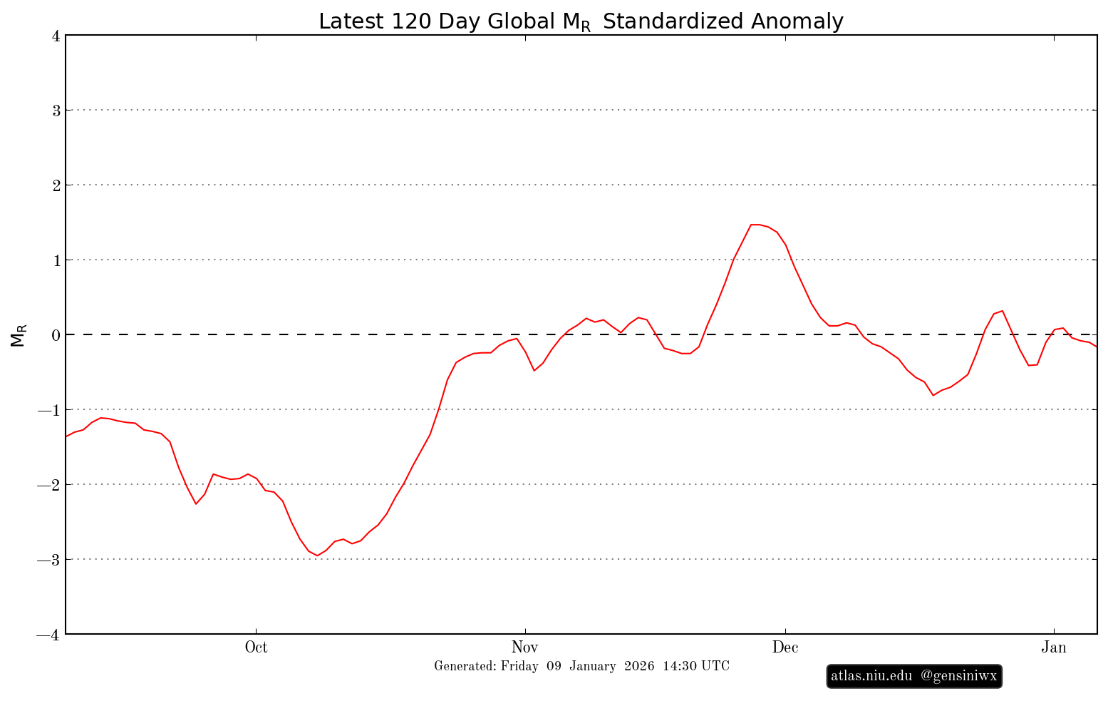
Oh I like that graph.
-

January 2026 regional war/obs/disco thread
CoastalWx replied to Baroclinic Zone's topic in New England
Yeah I’m not greedy. Just something other than 1-3” of fluff. Feb 16 did that here. Was paste for awhile and finally dropped below 30 second half. Even had some tree damage in that. 6z gfs was similar to what you said. Mixed here going to snow. Temp drops on NE winds like the days of yore. -

January 2026 regional war/obs/disco thread
moneypitmike replied to Baroclinic Zone's topic in New England
No doubt, bare ground is in store for SNE. Different story for CNE and NNE as they have more snow and it will remain both cooler and snowier. As one would expect. 33 already in PVD vs. 27 at Pit2. Off to rake more leaves. -
That is a horrific map. Not sure what they were looking. Usually the NESIS maps are good for looking at the general idea of the snow distribution despite being too conservative, but this map is completely wrong and way too aggressive with the snow in SNE and NJ/NYC
-

2025-2026 ENSO
40/70 Benchmark replied to 40/70 Benchmark's topic in Weather Forecasting and Discussion
@michsnowfreak -

January 2026 regional war/obs/disco thread
dryslot replied to Baroclinic Zone's topic in New England
Was colder then the county this morning here. 782 ASUS41 KGYX 091110 RWRGYX WEATHER ROUNDUP FOR MAINE AND NEW HAMPSHIRE NATIONAL WEATHER SERVICE GRAY ME 600 AM EST FRI JAN 09 2026 * THESE REPORTS ARE NOT UNDER NWS QUALITY CONTROL AND/OR DO NOT REPORT WEATHER SUCH AS PRECIPITATION AND FOG. MEZ002-005-006-010-012-015-018-020-021-024-026-027-029-091200- MAINE CITY SKY/WX TMP DP RH WIND PRES REMARKS PORTLAND CLEAR 20 19 96 CALM 30.33S SANFORD* CLEAR 14 11 87 CALM 30.31F BAR HARBOR CLEAR 23 21 92 CALM 30.36R WISCASSET CLEAR 19 15 84 CALM 30.34F ROCKLAND* CLEAR 20 19 96 CALM N/A FRYEBURG CLOUDY 11 7 84 CALM 30.30F LEWISTONAUBURN CLEAR 14 12 92 CALM 30.32S AUGUSTA CLEAR 22 19 89 SE3 30.31F WATERVILLE* CLEAR 18 16 93 CALM 30.29F FOG BANGOR CLEAR 17 16 95 CALM 30.34R GREENVILLE N/A 26 25 96 SE5 30.21R MILLINOCKET CLOUDY 30 25 81 CALM 30.30S HOULTON CLOUDY 29 25 85 CALM 30.26F PRESQUE ISLE CLOUDY 29 26 89 S6 30.26F FRENCHVILLE CLOUDY 27 24 89 S7 30.20S CARIBOU CLOUDY 28 25 88 SW5 30.24S $$ -

January 2026 regional war/obs/disco thread
mahk_webstah replied to Baroclinic Zone's topic in New England
With the systems in a medium to long range me it’s not about what it looks like. In a particular moment in time it’s more about the way things are trending. It seems like it’s trending in a gooddirection, but of course that may not continue. But I think we’re gonna get some snow storms in the next few weeks just based on both the availability, cold air and what models seem to be signaling as a more active storm track. -
Now I don't quite remember...when's the last time we had a trough that deep over us in a nina?
-
January 2026 regional war/obs/disco thread
jbenedet replied to Baroclinic Zone's topic in New England
Agreed on the sun. But atmosphere is cooked just above the surface. -
Have you and Mitch gotten married?. Retirement hasn’t been good for either of you.
-
January 2026 regional war/obs/disco thread
Typhoon Tip replied to Baroclinic Zone's topic in New England
It's going to be an interesting challenge for the feeble early January sun. 50 is a 32 F recovery for a lot of these locales around here. Easier done even a month from now. -

2025-2026 ENSO
michsnowfreak replied to 40/70 Benchmark's topic in Weather Forecasting and Discussion
I know youve mentioned you like March...but what do you mean for February re: the knockout punch? Traditionally the east IS warmer but not all out torch like some imply. I really like the look for here. A lot of Nina Februarys have a really nice snowy pattern (but also some mild days). Plus Feb has killed it the last few decades. -

January 2026 Medium/Long Range Discussion
Scarlet Pimpernel replied to snowfan's topic in Mid Atlantic
It's the AIAmWx model! Nearly 100% accurate every winter and actually doesn't require "AI" per se!!! The only slight modification is that Ji canceling winter for the "22nd time" is a bit underdone, he usually is at that point by Halloween! Oh, and also...we then get a "surprise" moderate or somewhat better storm at the very end of February or first part of March to kind of salvage things, but a lot of people go "meh, March snows suck because they're gone in 2 days anyhow!" -

January 2026 regional war/obs/disco thread
ORH_wxman replied to Baroclinic Zone's topic in New England
The weekend system also kind of sneakily morphed into a pretty low QPF event. Almost that shredded SWFE look on the precip. The bulk of the WCB misses to our east and the CCB is way back up in eastern Ontario/western Quebec. Leaves us kind of in a dead zone of forcing in between the two. -
Lol the differnce between the blues and dark grey's is literally. 1 to .3. That map makes it look worse than it is. Would I like it to be full of purples and pinks for us? Sure but another few 10ths of an inch of snow and the entire area would be in the "blue"
-
Winter 2025-26 Medium/Long Range Discussion
michsnowfreak replied to michsnowfreak's topic in Lakes/Ohio Valley
It varies by location, but generally the mid-January to early February is the coldest period of the year in this region (at Detroit, the coldest 2 weeks are January 18-31). So when you see ensemble maps with colder than avg temps during the coldest time of year - thats cold. Also, the colder than avg anomalies in already frigid places paired with the warmer than avg anomalies in already warm places mean a HUGE contrast in temps. This places our region in a great spot for potential. I mean, its just that, potential, but you definitely cant hate the look going forward. -

2025-2026 ENSO
so_whats_happening replied to 40/70 Benchmark's topic in Weather Forecasting and Discussion
Seems as though I was off a bit on overall progression of near normal for the region. Warmth extended a little bit longer than previously expected. As for the AAM maybe it is because it is standardized that it is different from the CFS forecast of showing around -1.
-
Indeed- I said my first word upon seeing the snow "wow!"
-
January 2026 regional war/obs/disco thread
jbenedet replied to Baroclinic Zone's topic in New England
NAM laughably too cold for surface temps today… These clouds are breaking… widespread mid 40’s easy and 50 within reach at many spots in SNE. -
January 2026 regional war/obs/disco thread
ORH_wxman replied to Baroclinic Zone's topic in New England
Yeah as the storm intensifies offshore, it pulls in that arctic airmass…that high is moving E at the same time. I honestly have no idea if we even get a storm, but assuming we got something semi-depicted, it could be one of those systems that starts as pure paste (or even mixed/rain on coastal plain) and then it advects in much colder air as it gets drawn into the CCB. The biggest big dog in Mar ‘18 kind of did that. First few inches were like spackle here and then we ended up with 2 feet, the latter 20” was mostly pure powder as temps plummeted in the CCB. At this point, I’d take just a minimal warning event and I’d consider that a huge win if we somehow squeezed out that type of event next Friday. -
06z doesn’t go out far enough on the Euro but geez it looked like it was about to hammer us for the first storm.
-
January 2026 regional war/obs/disco thread
40/70 Benchmark replied to Baroclinic Zone's topic in New England
Gonna look at everything this weekend and probably write something up.....maybe also urinate a snowflake onto a napkin for Steve to understand. -
January 2026 regional war/obs/disco thread
Typhoon Tip replied to Baroclinic Zone's topic in New England
ah yeah. no did not loop it. I was in fact knee jerk reacting to that as a scalar "nice looking set up". Which if we didn't know the history, I would still argue that doesn't look that good. However, upon knowing/looping, yeah we can see that the wind barbs along and off the EC are pivoting toward more SW from W/WSW direction.. That's some slowing of the progressive aspect; probably going to be enough to allow that WI knife to 'catch up'. Still don't like the QUE position up there but probably what happens is there's a potent result with a very sharp N deform axis type deal