All Activity
- Past hour
-

July 2025 Discussion-OBS - seasonable summer variability
SACRUS replied to wdrag's topic in New York City Metro
Records: Highs: EWR: 104 (2012) NYC: 101 (1953) LGA: 101 (2012) JFK: 100 (2013) New Brnswick: 100 (1905) Lows: EWR: 58 (1946) NYC: 57 (1925) LGA: 62 (1962) JFK: 58 (1962) New Brnswick: 53 (1925) Historical: 1889 - A cloudburst in West Virginia along the small creeks in Wirt County, Jackson County and Wood County claimed twenty lives. Rockport, WV, reported nineteen inches of rain in two hours and ten minutes that Thursday evening. Tygart Creek rose 22 feet in one hour, and villages were swept away on Tygart, Slate, Tucker, and Sandy Creeks. (The Weather Channel) 1936 - The all time record high temperature for the state of Kansas was set when a 121-degree high temperature fried Fredonia. (US National Weather Service Wichita) 1936: This day marked the end of the hottest period on record for La Crosse, WI. From the 5th through the 18th, temperatures climbed to 90° or better everyday, and at or above 100° eight times. During this time six record temperatures were set and the average high temperatures for the period was 101.0°. (Ref. Wilson Wx. History) 1942: A record deluge occurred at Smethport in northern Pennsylvania, with 30.7 inches in just six hours. The downpours and resultant flooding in Pennsylvania were devastating. The following U.S. records were set at Smethport, PA: rainfall in three hours: 28.50 inches, rainfall in 4 hours and 30 minutes: 30.70 inches and 12-hour rainfall: 34.30 inches.(Ref. Wilson Wx. History) 1942 - A record deluge occurred at Smethport in northern Pennsylvania, with 30.7 inches in just six hours. The downpours and resultant flooding in Pennsylvania were devastating. (David Ludlum) 1970: A tropical depression formed east of the Yucatan Peninsula. As the system developed into Tropical Storm Becky, it provided National Hurricane Center forecasters their first opportunity to study the evolution of a tropical cyclone with the aid of time-lapse movies of ATS (Applications Technology Satellite) photographs in real time, or, The Movie Loop. Becky moved into the Florida panhandle as a tropical storm. (Ref. Wilson Wx. History) 1972: Heavy rain, unofficially measured at 10 to 11 inches, fell in the Mooreland and Mutual areas of Woodward County Oklahoma. The heavy rain caused severe soil erosion, but crop damage was minimal, as wheat already had been harvested. (Ref. Wilson Wx. History) 1986 - One of the most photo-genic tornadoes touched down in the northern suburbs of Minneapolis, MN, during the late afternoon. The very slow moving tornado actually appeared live on the evening news by way of an aerial video taken by the KARE-TV helicopter crew. The tornado, unlike most, was quite the prima donna, staying visible to tens of thousands of persons for thirty minutes. It was moderate in intensity, with winds of 113-157 mph, and caused 650 thousand dollars damage. (Storm Data) 1987 - Cool weather prevailed in the western U.S. Seven cities reported record low temperatures for the date, including Alamosa, CO, with a reading of 38 degrees. The low of 52 degrees at Bakersfield, CA, was a record for July. Up to eight inches of snow covered the Northern Sierra Nevada Range of California from a storm the previous day. During that storm, winds gusting to 52 mph at Slide Mountain, NV, produced a wind chill reading of 20 degrees below zero. Susanville, CA, reached 17 degrees that previous day, Blue Canyon, CA, dipped to a July record of 36 degrees, and the high of 44 degrees at Klamath Falls, OR, smashed their previous record for July by ten degrees. (The National Weather Summary) 1988 - Sweltering heat continued in California, with record highs of 111 degrees at Redding and 112 degrees at Sacramento. Death Valley, CA, hit 127 degrees. Late afternoon and evening thunderstorms in the Central Plains Region produced baseball size hail at Kimball, NE, wind gusts to 79 mph at Colby, KS, and six inches of rain near Lexington, NE. (The National Weather Summary) (Storm Data) 1989 - Thunderstorms produced severe weather in Oklahoma, northern Texas and Arkansas during the afternoon, and into the night. Thunderstorms produced baseball size hail at Stamford, TX, and wind gusts to 92 mph near Throckmorton, TX. Record heat continued in the southwestern U.S. Phoenix AZ reported a record high of 115 degrees, and a 111 degree reading at Midland, TX, was second only to their all-time record high of 112 degrees established sixteen days earlier. (The National Weather Summary) 1992: On this date through the 18th, Thunderstorms crossed Wayne County in western New York State dumping heavy rains over already saturated grounds and swollen streams. Rainfall amounts exceeded six inches in two hours on the 17th. (Ref. Wilson Wx. History) 1993: In south central Kansas, heavy rains in and around Stafford County caused flooding of the normally dry Antelope Creek. Flooding of roads and streets began in Radium during the morning hours. The flooding continued until the morning hours on the 19th. This was the worst flooding in Radium since the spring of 1973. Flooding continued until about 9 am on the 19th. (Ref. Wilson Wx. History) 1996: An F5 tornado struck Oakfield, WI during the evening, injuring 17 people and destroying 47 of the 320 homes in the town. Damage estimates totaled over $40 million dollars. In addition, 56 homes as well as numerous businesses and churches sustained heavy damage. A massive rainstorm in north central and northeast Illinois led to widespread flooding. Aurora reported 16.91 inches of rain, establishing a state record for the most rain in a single day. Other heavy totals included 13.60 inches at Joliet, 9.24 inches in Wheaton, 8.09 inches in DeKalb, and 7.82 inches at Elgin. (Ref. Wilson Wx. History) 1997: Hurricane warnings were posted along the Gulf Coast from Louisiana to Alabama as Hurricane Danny headed toward shore, first brushing southeastern Louisiana where tropical storm force winds and high tides caused severe erosion. Grand Isle, LA recorded a wind gust to 95 mph shortly before midnight. 100 mph winds and torrential rains, downed power lines, damaged or sunk boats and left flooding in its wake. Thunderstorms developed ahead of a strong cold front and brought high winds and large hail to the western southern tier, Niagara frontier and Genesee Valley in western New York State. A 74 mph gust was recorded in Orchard Park. Hail, as large as golf balls, damaged crops in Niagara and Orleans counties. Several fires were reported as a result of lightning strikes. (Ref. Wilson Wx. History) 2003: Miles City, MT set their all-time high temperature record with 113°. Highs of 100° or higher occurred 6 times between the 12th through the 19th. (Ref. Wilson Wx. History) . 2008: A man and a woman went outside a home in Standish, ME to get a pair of sunglasses the family dog had taken from 1 of the 3 young children inside. Unfortunately, lightning hit a nearby tree, then traveled through the ground, killing both people. (Weather Guide Calendar with Phenomenal Weather Events 2011 Accord Pub. 2010, USA) 2010: Thunderstorm winds gusted to 72 mph at BWI late evening on 18th. Ref. July PRESTO Page 1 -

July 2025 Obs/Disco ... possible historic month for heat
Brewbeer replied to Typhoon Tip's topic in New England
weather is much improved this morning, windows open, 72/60. -

July 2025 Discussion-OBS - seasonable summer variability
bluewave replied to wdrag's topic in New York City Metro
The 90° reading for JFK at 10pm was pretty impressive. The all-time 10pm record high at JFK was 95° set back on July 5th 1999. So anytime we are near 90° this late into the evening people notice since it close to the record values. This allowed the record low max at ISP set earlier in the day to hold. A 79° low for anywhere in Suffolk County is very impressive. You can see it beat the previous record by +4°. The warmest low max ever at ISP was 81°. RECORD EVENT REPORT NATIONAL WEATHER SERVICE NEW YORK, NY 316 AM EDT FRI JUL 18 2025 ...RECORD DAILY HIGH MINIMUM TEMPERATURE SET AT ISLIP NY... THE LOW TEMPERATURE WAS ONLY 79 DEGREES THURSDAY, JULY 17 AT ISLIP MACARTHUR AIRPORT. THIS BREAKS THE OLD RECORD HIGH MINIMUM OF 75 DEGREES, LAST SET IN 2021. RECORDS FOR THE ISLIP NY AREA GO BACK TO 1963. ALL CLIMATE DATA ARE CONSIDERED PRELIMINARY UNTIL REVIEWED BY THE NATIONAL CENTERS FOR ENVIRONMENTAL INFORMATION (NCEI). -
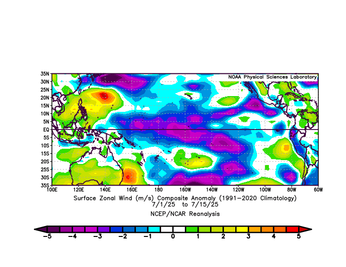
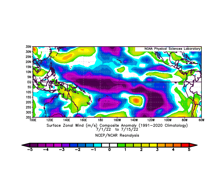
The record WPAC warm pool and cooler waters east of the Dateline have been driving these stronger EWBs. So the actual Nino 3.4 SSTs aren’t that important. It’s the SST difference driving the La Niña background. This was the strongest early July EWB near the Dateline since 2022 but not quite as strong.The RONI also tries to approximate this difference which keeps this persistent La Niña background going whether the actual Nino 3.4 is closer to neutral or below -1.
-
July 2025 Discussion-OBS - seasonable summer variability
SACRUS replied to wdrag's topic in New York City Metro
76 / 64 and mostly cloudy. Partly cloudy forecasts look optimistic. Cooler / drier - likely a break in the 3/4 day heatwave for many, enough sun could get the hottest spots inland there but it looks cloudy. Weekend looks 50/50 - cloudy and scattered storms Saturday warm / humid with a drying out Sunday by the afternoon. Enough Sun on Sun gets the hottest spots to 90. Drier 2-3 days - cooler Mon - Wed before ridge builds heights and heat expands east by the 24/25th, with potential strong heat later next week / weekend. Overall warm - hot / humid beyond there and likely wetter again with ridge building to our west. 7/18 - 7/20 : Warm - Storms chances Saturday, Drying out Sunday / clearing 7/21 - 7/23 : Cooler / Drier 7/24 - 7/30: Hotter / Humid wetter - potential stronger heat 25-27 -

July 2025 Obs/Disco ... possible historic month for heat
CoastalWx replied to Typhoon Tip's topic in New England
At least the low was above 70 here so that’s good. -
July 2025 Obs/Disco ... possible historic month for heat
CoastalWx replied to Typhoon Tip's topic in New England
74-75 around them. * -
July 2025 Discussion-OBS - seasonable summer variability
bluewave replied to wdrag's topic in New York City Metro
Pattern persistence. So we get cooler and more clouds during the weekend with shower or drizzle chances. The best beach days have been during the week especially for the heat like we just experienced last few days. The next heatwave with 95° to 100° potential will be next Thursday and Friday. Models showing cooler and showers clouds chances again for next weekend also. Gets back to the stuck weather patterns which have become so common over the last decade. -

July 2025 Obs/Disco ... possible historic month for heat
BrianW replied to Typhoon Tip's topic in New England
Still waiting for my cool down. Was 88 at HVN all the way up midnight and it's currently 79..thumb.png.ab2cbbd67b6b4a67e5db592b73b99aa8.png)
-

July 2025 Obs/Disco ... possible historic month for heat
Damage In Tolland replied to Typhoon Tip's topic in New England
Reds and orange in all directions ! -

July 2025 Obs/Disco ... possible historic month for heat
RUNNAWAYICEBERG replied to Typhoon Tip's topic in New England
We’ll be blue next year. -

July 2025 Discussion-OBS - seasonable summer variability
winterwarlock replied to wdrag's topic in New York City Metro
What happened to the sunny Saturday we are suppose to have Cruddy beach weekends roll on -
July 2025 Obs/Disco ... possible historic month for heat
CoastalWx replied to Typhoon Tip's topic in New England
Dews will be in the 60s by late tomorrow afternoon. Sweat down the crack tomorrow night and Sunday. -
July 2025 Obs/Disco ... possible historic month for heat
CoastalWx replied to Typhoon Tip's topic in New England
Used to be blue. On our way to turning that orange. -

July 2025 Obs/Disco ... possible historic month for heat
dendrite replied to Typhoon Tip's topic in New England
64.4/58 Cold! -

July 2025 Obs/Disco ... possible historic month for heat
jbenedet replied to Typhoon Tip's topic in New England
Shocker. Siggy -NAO on the teles. -
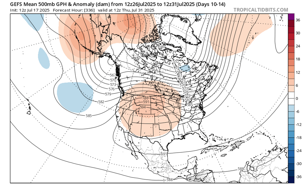
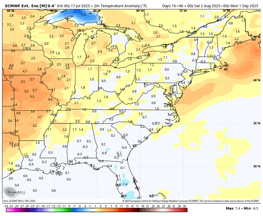
Upper ridge builds out west for the last week of July and looks to persist into early August. We will still see some hot weather ofc, but not the oppressively high dewpoints.
-

July 2025 Obs/Disco ... possible historic month for heat
kdxken replied to Typhoon Tip's topic in New England

-
I’m talking wide spread CONUS summer humidity/heat this extreme
- Today
-
July 2025 Obs/Disco ... possible historic month for heat
kdxken replied to Typhoon Tip's topic in New England
Glad we don't live there.
-

2025-2026 ENSO
so_whats_happening replied to 40/70 Benchmark's topic in Weather Forecasting and Discussion
Subsurface for June and the first half of July..thumb.gif.4dd911703b260808903981836c1348c6.gif)
-
2025-2026 ENSO
so_whats_happening replied to 40/70 Benchmark's topic in Weather Forecasting and Discussion
Impressive a 606 in 2005 -

July 2025 Obs/Disco ... possible historic month for heat
w1pf replied to Typhoon Tip's topic in New England
Nice.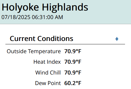
-
If you want to look at long-term trends, Its important to separate station changes from weather changes. The city to airport transition in Detroit introduces a bias. The City airport is warmer than Metro, particularly for low temperatures. I've looked at Ann Arbor, Pontiac, Detroit City and Detroit metro. Pontiac and Ann Arbor both go back 100+ years. I see a warming of winter extreme temps at each site. Less at the city airport and most at Pontiac. Note that I showed data for daytime highs, because low temperatures are more likely to be impacted by heat island and other local site radiating conditions. One final comment. Decade data can be misleading because 2010-2019 gives a different answer than 2015-24. In the case of extreme winter weather the difference in 10-year snapshots is amplified by large natural variability. We are still going to get cold shots and no question the 2010s had an unusual concentration. Don't see evidence though that Detroit is getting the same degree of extreme cold that it did in the past.
-
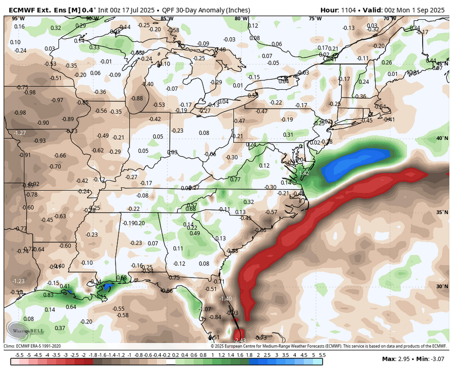
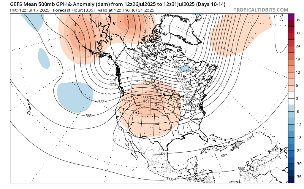
Latest WB weeklies now go through August....extreme heat stays out west....

.png.502020b6edf3235659073a50b386e183.png)


.gif.8d4e2f8f373a815a253ee8cd7f9dc5a4.gif)