All Activity
- Past hour
-

E PA/NJ/DE Summer 2025 Obs/Discussion
BBasile replied to Hurricane Agnes's topic in Philadelphia Region
Yes, I cant wait!!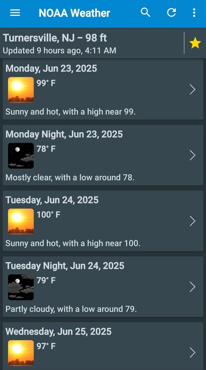
-
I can definitely see low 100s in the favored areas Monday and Tuesday... maybe Wednesday too
-
I liked your idea of a feeble kind of onshore wind unable to really cool beach/shore roads down much below 87 or so, while the baseball fields just inland have EMTs hauling heat victims away... (well, you didn't say that but I'm havin fun with it ) This could also be a great way to draw sharks closer to the Atlantic side swimmers, huh.
-
i have baby oak trees growing all over my lawn from last years acorns. I really don't want that again. i am actually kicking around the idea of taking down 3-4 big oaks in my yard. there will still be some, but those 3-4 trees make a ton of acorns and fall clean up is no joy with all those leaves.
-
Euro is a torch Wed-Thurs SoP. Bumped a bit warmer there. Still the same Sun-Tues. One of the days could have a weak seabreeze, more likely on Monday.
-
Major seabreeze on the 12z Euro for Monday, but Tuesday we go to 106 for a fairly large area
-
Expect it to be wasted.
-
Of course what you say is true, I was being silly lol I was being sarcastic because people blame UHI for everything. How does UHI explain record breaking 850mb temperatures for example? It doesn't, but people will continue to blame the airport or the concrete at sea level.
-
Granted it’s only the point and click but I don’t think I’ve ever seen “100” in a local forecast especially three days out. With regards to the tstorm potential this weekend I like that there could be an EML in place: but will also lead to the eastward advection of extremely steep lapse rates in the 700 to 500 mb layer from the northern Plains and Rockies, which meteorologists refer to as an "elevated mixed layer".
-
In Saratoga until Sunday - quite nice up here, 75F but a bit breezy. Just looked ahead and Tuesday looks downright hot even back home on the coast. Woof. The central air finally goes on I suppose.
-

Fall/Winter Banter - Football, Basketball, Snowball?
angelnicaella replied to John1122's topic in Tennessee Valley
Yo, bring on the cold and the chaos! Nothing like fall ball and snow squalls to spice up the smack talk. Let the wild takes fly — football flops, buzzer-beaters, and rogue snowstorms, I’m here for all of it. -
angelnicaella joined the community
-
It's definitely a notable heat dome. Yesterday's late afternoon high was 115, which is about the hottest I've experienced since living here the past four years. It has begun its departure east so we're cooling off today (109) going into next week as temps fall back to the lower 100s.
-
The older I get the less I like Summer (I will be 51 in August). Heat, humidity, tourist traffic, bugs & crazy high energy bills due to trying to stay cool. In my younger days, I loved all things summer - now, I could do without it. Fall is actually my favorite season & now winter is a close second.
-
The short term model guidance is pretty toasty for early next week, especially the overnight lows.
-
An interesting study that helps explain other recent findings. Plain Language Summary Analysis of satellite observations shows that in the past 24 years the Earth's storm cloud zones in the tropics and the middle latitudes have been contracting at a rate of 1.5%–3% per decade. This cloud contraction, along with cloud cover decreases at low latitudes, allows more solar radiation to reach the Earth's surface. When the contribution of all cloud changes is calculated, the storm cloud contraction is found to be the main contributor to the observed increase of the Earth's solar absorption during the 21st century. The paper also discusses the causes. An important contributing factor is a shift of clouds polewards in part due to Hadley Cell expansion. https://agupubs.onlinelibrary.wiley.com/doi/10.1029/2025GL114882
-
Another horrific acorn year is here. Picking up all these limbs and they’re loaded for bear WTF
-
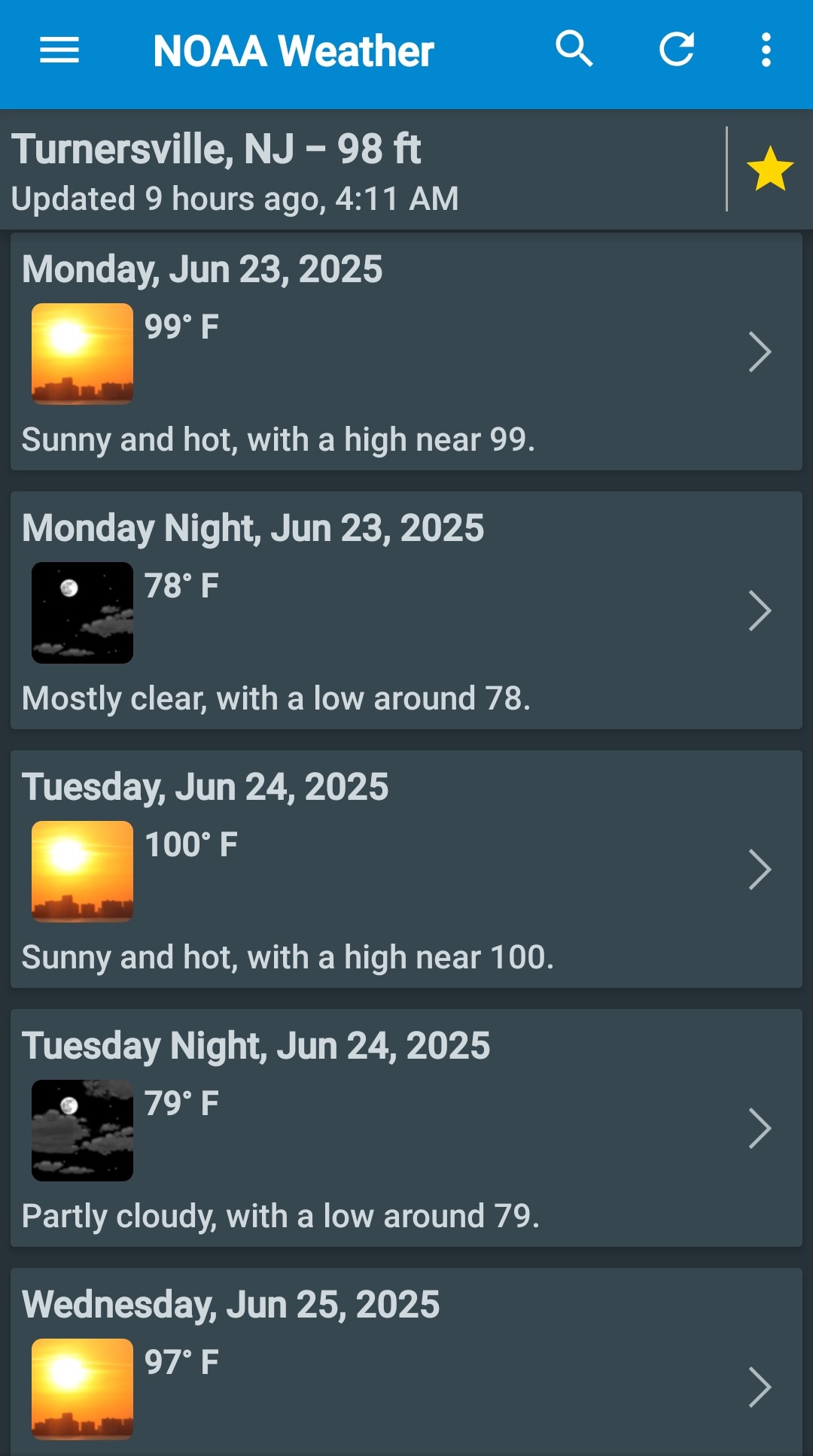
Extreme Heat Watches hoisted
-
81 / 56 partly cloudy as some clouds move in from the north
-
JFK highest was 99 in 1949: Day High (°F) Low (°F) Precip. (inches) Snow (inches) June 1 73 53 0.00 0.0 June 2 71 53 0.00 0.0 June 3 70 52 0.00 0.0 June 4 75 56 0.00 0.0 June 5 76 65 0.00 0.0 June 6 79 64 0.00 0.0 June 7 84 61 0.00 0.0 June 8 73 53 0.00 0.0 June 9 72 53 0.00 0.0 June 10 69 55 0.00 0.0 June 11 79 62 0.00 0.0 June 12 80 66 0.00 0.0 June 13 76 65 0.00 0.0 June 14 76 65 0.00 0.0 June 15 79 65 0.00 0.0 June 16 82 67 0.00 0.0 June 17 82 69 0.00 0.0 June 18 82 70 0.00 0.0 June 19 81 71 0.00 0.0 June 20 82 69 0.00 0.0 June 21 87 73 0.00 0.0 June 22 91 71 0.00 0.0 June 23 88 68 0.00 0.0 June 24 86 65 0.00 0.0 June 25 85 71 0.00 0.0 June 26 99 75 0.00 0.0 June 27 93 66 0.00 0.0 June 28 77 62 0.00 0.0 June 29 75 60 0.00 0.0 June 30 76 62 0.00 0.0 July 1949 JFK Airport Weather Day High (°F) Low (°F) Precip. (inches) Snow (inches) July 1 81 62 0.00 0.0 July 2 84 67 0.00 0.0 July 3 92 72 0.00 0.0 July 4 96 76 0.00 0.0 July 5 96 76 0.00 0.0 July 6 83 69 0.40 0.0 July 7 80 64 0.03 0.0 July 8 78 65 0.00 0.0 July 9 78 65 0.00 0.0 July 10 77 69 0.05 0.0 July 11 84 67 0.00 0.0 July 12 78 71 0.21 0.0 July 13 83 70 0.67 0.0 July 14 88 70 0.00 0.0 July 15 83 72 0.00 0.0 July 16 81 72 0.00 0.0 July 17 76 70 0.83 0.0 July 18 90 74 0.00 0.0 July 19 89 75 0.00 0.0 July 20 87 75 0.00 0.0 July 21 91 78 0.00 0.0 July 22 94 76 0.00 0.0 July 23 91 73 0.00 0.0 July 24 84 64 0.00 0.0 July 25 90 71 0.16 0.0 July 26 84 71 0.00 0.0 July 27 84 71 0.22 0.0 July 28 98 70 0.00 0.0 July 29 94 76 0.00 0.0 July 30 93 77 0.00 0.0 July 31 86 74 0.00 0.0 August 1949 JFK Airport Weather Day High (°F) Low (°F) Precip. (inches) Snow (inches) August 1 85 67 0.00 0.0 August 2 83 67 0.00 0.0 August 3 83 72 0.08 0.0 August 4 78 73 0.52 0.0 August 5 84 72 0.00 0.0 August 6 90 70 0.00 0.0 August 7 89 71 0.00 0.0 August 8 89 72 0.00 0.0 August 9 95 75 0.00 0.0 August 10 94 76 0.00 0.0 August 11 99 76 0.02 0.0 August 12 88 70 0.88 0.0 August 13 80 68 1.53 0.0 August 14 79 68 0.00 0.0 August 15 78 64 0.00 0.0 August 16 80 68 0.02 0.0 August 17 78 65 0.00 0.0 August 18 74 64 0.00 0.0 August 19 80 62 0.00 0.0 August 20 77 55 0.00 0.0 August 21 83 56 0.00 0.0 August 22 80 63 0.00 0.0 August 23 82 61 0.00 0.0 August 24 83 69 0.36 0.0 August 25 78 61 0.00 0.0 August 26 82 63 0.00 0.0 August 27 85 70 0.00 0.0 August 28 81 72 0.00 0.0 August 29 84 69 0.39 0.0 August 30 80 65 0.00 0.0 August 31 78 68 1.47 0.0 September 1949 JFK Airport Weather Day High (°F) Low (°F) Precip. (inches) Snow (inches) September 1 82 63 0.08 0.0 September 2 74 53 0.00 0.0 September 3 76 56 0.00 0.0 September 4 76 59 0.00 0.0 September 5 78 67 0.42 0.0 September 6 78 59 0.19 0.0 September 7 70 54 0.00 0.0
-
It's possible the srfc temps could be tainted at times with erly flow, especially at the coast. But weaken the erly gradient enough and with 18-20C 850 temps....you'll have one of those 85F ESE seabreezes on runway 090 at Logan while West Roxbury is 96. It does seem like we may try to trough more towards the 4th. At least on the EPS.
-

E PA/NJ/DE Summer 2025 Obs/Discussion
Hurricane Agnes replied to Hurricane Agnes's topic in Philadelphia Region
I think they also changed the product name from "Excessive Heat Watch" to "Extreme Heat Watch" too. -
Happy solar noon on solstice day!
- Today
-
These complexes can be very frustrating!! Countless times I have watched radar thinking there is no way this is going to miss and 10-15 minutes later, it is like some secret power has blocked your backyard from getting anything fun!! Joe Lundberg from Accuweather kindly spent some time educating me (like 20 years ago back when JB and Ken Reeves were all there) about LLJ dynamics and thermal and energy impacts on these complexes. It really helped me and I fully understand what is happening but still amazes me when a massive red blob 15 miles or so on radar can be heading right for you and you get nothing!!
-
Also the occasional chipmunk! Did note 14,000 outages in MA and scattered reports across eastern NY and Northern New England... Bottom line is the New England region has an aging dense hardwood tree canopy with an abundance of diseased and previous damaged trees! We need either a derecho or CAT 3 to clean house...
-
Scott's right in that assessment ... it's a warmer than normal mid latitude continent synoptic and super synoptic ( tendency...) through 300+ hours. The GFS actually rolls big heat back in by next Saturday, and I'm not completely sold on the idea that Thur and Frid will really turn out that corrected. Even if so, it transient and would likely yield the bigger signal with at least episodic heat returns. GGEM is essentially the same.