All Activity
- Past hour
-

2026-2027 Record-breaking El Nino
GaWx replied to Stormchaserchuck1's topic in Weather Forecasting and Discussion
Here’s the preliminary winter outlook from pro met. Chris Martz: here is my preliminary thinking. . . As y'all probably know by now because of the endless hysteria in the news cycle, we are in an El Niño, which is just the warm phase of the larger El Niño–Southern Oscillation (ENSO). This year, the developing El Niño is unusually intense, and it is expected to officially be a “very strong” El Niño by early winter at the latest. This is marked by very warm sea surface temperatures in the equatorial Pacific Ocean. The news media and the United Nations have spun this as some sort of crazy event that will “turbocharge” extreme weather all over the globe, but that's not really how it works. Now, normally in the tropical Pacific Ocean, easterly wind stress associated with the Walker Circulation imparted on the sea surface acts to pile warm water near the surface in the western half of the basin; that is, closer to Asia. This pushes the thermocline down towards the west as warm water pools up north of the Maritime Continent and east of the Philippines. But during El Niño, the easterlies weaken or temporarily reverse (westerly wind bursts), which causes that pool of warm water to slosh back east. That's what's happening right now. There are a lot of meteorological factors to consider when it comes to predicting long-range temperatures, precipitation, and storm tracks. But this year, this “very strong” El Niño will play a dominant role I think as it has in years past (e.g., 1982–83, 1997–98, and 2015–16). Those are my top post-1950 analogs, and I added 1972–73 into the mix as it behaved similarly to the others, although it was only a “strong” El Niño at peak intensity. 1827–28 and 1877–78 would have been good analogs too, but we don't have enough climate data from back then to work with. A key feature of “very strong” El Niño events is that wintertime temperatures are particularly mild relative to average. This is pronounced in the Upper Plains / Midwest and Great Lakes / Northeast. Temperatures across the Desert Southwest and Four Corners region, however, typically run below average. The southeast can swing either way, but generally winds up near “average” (and I use scare quotes there because the weather is rarely “average”). However, these exceptionally mild temperatures do not necessarily persist all winter. In fact, most of this composite is due to “blowtorch” Decembers. And I do expect December to end up 5–10°F above average in the areas you see orange and red contours in the first analog composite map I made below. But the roaring Pacific Jet typically relaxes from mid-January through mid-February, so temperatures will tumble a bit closer to “seasonable.” If this El Niño were weaker, there'd be a good chance of a frigid December in the east. But I doubt that's going to happen. As far as precipitation goes, well, there should be an active subtropical jet stream. So, air parcels moving from west-to-east will tap into Gulf moisture and then be advected northward into the southeast. I expect a lot of rain in the Gulf Coast states (Texas to Florida) and then northward up the east coast into the DMV. Similarly, the western U.S. should expect some major drought relief due to atmospheric river events. After a near-record low snowpack last winter, the ski resorts will be back in business. Elsewhere, it will likely be a bit drier than normal due to persistent high-pressure ridging over the northern flank of the country. Storm tracks are going to favor the southern states. With respect to snowfall, overall, I do expect less of it nationwide outside of high elevation areas simply due to higher-than-average temperatures. But I cannot rule out ONE crippling blizzard in the Mid-Atlantic or in the southeast. It happened in the southeast (Florida, Georgia, and Carolina coastline) in February 1973 and in the lower Mid-Atlantic (Virginia, D.C., Maryland, and southeastern Pennsylvania) in both February 1983 and January 2016. However, it did not happen in 1827–28 or 1877–78 (I checked NOAA NCEI FORT data) or in 1997–98. So, whether or not we get the “big one” remains up in the air for now. But it will be that one storm that will ultimately determine where the seasonal snowfall will stand (above / below climatology) in the southeast and Mid-Atlantic. If it occurs, many folks will get their seasonal spoonful of snow in one dumping. If it does not occur, it's just going to be a wet winter. -
HRRR has a pretty good soaker for IA and most of northern IL through tomorrow morning.
-

Septorcher 2026 Discussion - Endless Summer
Damage In Tolland replied to Damage In Tolland's topic in New England
Thru week 6. Stein except congrats Dendy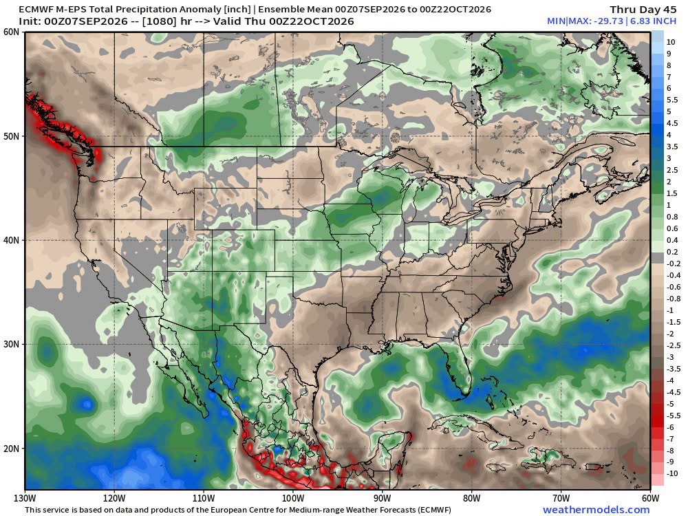
-
low of 61 at 6:35am, high of 88 at 5:38pm.
-
 cost of propecia pills: HairGuardRx : buy cheap propecia prices
 - Yesterday
-
Not sure if anyone posted it, but the Sept edition of the NMME is slightly warmer for DJF than the Aug run, very similar to the CanSIPS.
-
Thanks, more to come. I don't remember 93-94 at all, even 95-96. I have a lot of nostalgia for 00-01 and 02-03 though.
-
Low of 67. Beautiful morning today.
-

2026-2027 Record-breaking El Nino
Ephesians2 replied to Stormchaserchuck1's topic in Weather Forecasting and Discussion
The warm pool definitely isn't as extreme as it was a month ago -

Septorcher 2026 Discussion - Endless Summer
Brewbeer replied to Damage In Tolland's topic in New England
68/64, cloudy, calm boring weather, such as it is, is the best take -
Yeah not great, but still a higher than normal chance for the big one
-
cytotec online: CytoCarePharma or buy cytotec online
-
cost of propecia without dr prescription: HairGuardRx - order propecia without dr prescription
-
Here is newark 90 degree Days: Year Rank Days >= 90 °F 2010 1 54 2022 2 49 1993 2 49 1988 4 43 2021 5 41 2002 5 41 1991 5 41 2016 8 40 1983 8 40 1959 8 40 2025 11 39 1994 11 39 1944 11 39 2005 14 37 1987 14 37 2018 16 36 1949 16 36 2015 18 35 1961 19 34 2024 20 33 2012 20 33 1999 20 33 1995 20 33 1966 20 33 95 Degree Days Year Rank Days >= 95 °F 1993 1 25 2010 2 21 1944 3 20 1988 3 20 2022 3 20 2021 6 18 1955 7 17 2002 7 17 2011 7 17 2012 7 17 1949 11 16 1953 12 14 2005 12 14 2025 12 14 1987 15 13 1991 15 13 1999 15 13 2016 15 13
-
https://cytocarepharma.com/# order cytotec online
-
Tony did 1993 tie 1991 there or exceed it?
-
Our local forecasters have said that 10 of the last 14 days have been below normal. It just hasn't been hot since July 15th. 80 degrees is an easy bar to clear in the summer as long as it's sunny and we are finally in a nice dry stretch with just an occasional frontal passage. I think we'll finally get a nice dry month now.
-
I know but look at it this way. The Yankees need to hit home runs to win games and it's easier to hit home runs in hotter weather.
-
My thoughts are that its subpar from average, but not as much as some are assuming with a strong nino.
-
The wind is incredibly calm right now considering the sun is still out Another great day. High 80, low 58
-
buy misoprostol over the counter and Misoprostol 200 mg buy online cytotec pills buy online https://images.google.co.uz/url?q=https://cytocarepharma.com cytotec online and http://lenhong.fr/user/hicvgwrtpf/ cytotec online [url=https://www.google.ml/url?sa=t&url=https://cytocarepharma.com]п»їcytotec pills online[/url] п»їcytotec pills online or [url=http://la-maison-des-amis.com/user/edgdhxlirx/]buy cytotec[/url] Abortion pills online
-
buy misoprostol over the counter and Misoprostol 200 mg buy online cytotec pills buy online https://images.google.co.uz/url?q=https://cytocarepharma.com cytotec online and http://lenhong.fr/user/hicvgwrtpf/ cytotec online [url=https://www.google.ml/url?sa=t&url=https://cytocarepharma.com]п»їcytotec pills online[/url] п»їcytotec pills online or [url=http://la-maison-des-amis.com/user/edgdhxlirx/]buy cytotec[/url] Abortion pills online
-
A shower coming moving SW from offshore started here ~5 minutes ago. It likely won’t amount to too much due to it likely being brief due to rapid movement and it not being large.
-

Septorcher 2026 Discussion - Endless Summer
Layman replied to Damage In Tolland's topic in New England
@CoastalWx may be on to something here beating the boring drum as the focus turns to natgas, pipelines and domestic policies rather than weather -

Septorcher 2026 Discussion - Endless Summer
BrianW replied to Damage In Tolland's topic in New England
Natural gas prices are state regulated by PURA. They have to submit rate increases and get them approved similar to electricity. I believe its every 6 months like electricity so the price is extremely stable for 6 months.