All Activity
- Past hour
-
That contributed to that 2014-2015 season being one of the best that I’ve seen since we moved to E TN in 2011. That year we exceeded 20in total snowfall, but it didn’t really get going until late Jan and ramped up in Feb. and into March.
-

E PA/NJ/DE Winter 2025-26 Obs/Discussion
The Iceman replied to LVblizzard's topic in Philadelphia Region
some of the other meso's last night also hinted at this. Will be interesting to see what they say today. Could be a sneak advisory level event with the timing especially upper bucks/lehigh valley by the delaware river. -

Another Coating of Snow Saturday - "It's all we Got"
dendrite replied to Sey-Mour Snow's topic in New England
HRRR is always playing catch up -
Does that mean it is right for Sunday too? lol
-
Will need advisories soon if trend continues into 18z runs and also euro and ukmet hold or get better
-
Gotta hand it to the 2 Canadians. They've had this threat for days with only minor adjustments.
-

January 2026 regional war/obs/disco thread
Sey-Mour Snow replied to Baroclinic Zone's topic in New England
Enormous potential, but I'm not celebrating yet, it was just last year we had and epic 2 week stretch modeled with 20" + on all ensembles.. I think 3-6" verified for most over 2 weeks.. -

January 16-19th: Rolling the dice
Stormchaserchuck1 replied to SnowenOutThere's topic in Mid Atlantic
Whoa! 2-3" snow depth tomorrow between Westminster and Hagerstown on the 12z NAM -

Another Coating of Snow Saturday - "It's all we Got"
HoarfrostHubb replied to Sey-Mour Snow's topic in New England
I think it can show some trends a bit more consistently (just eyeballing)... but it does seem to overso things -
12z NAM is going all in for interior areas.
-
Nam also nails northern and NE Maryland.
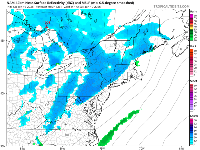
-

January 2026 regional war/obs/disco thread
40/70 Benchmark replied to Baroclinic Zone's topic in New England
If the late January pattern is south of me, I may honestly get the futility record here if the Feb SSW doesn't produce in March. -
E PA/NJ/DE Winter 2025-26 Obs/Discussion
The Iceman replied to LVblizzard's topic in Philadelphia Region
Yeah that 6z run was the weenie run of the century, can only get worse from there lol -
I was thinking 2015 also but I’m terrible with dates .
-
The initial band that was suppose to bring 1-2" was a flop. 0.1" of sn/sn pellets. But overnight brought 3". 3.1" for this clipper, so far. Will be snow showers later, so hopefully will pick up a little more. A general 3-4" around the head of the Lake with an area of 6-8" in N WI. 2-3" in the N.
-

First Legit Storm Potential of the Season Upon Us
CoastalWx replied to 40/70 Benchmark's topic in New England
I hit a nasty one on the X way the other day. -
First Legit Storm Potential of the Season Upon Us
dendrite replied to 40/70 Benchmark's topic in New England
Yup. There’s some sinkholes down the road here too. They had a cone blocking one the other day and when I drove by it yesterday the cone was shattered so someone got swallowed in it. -

Storm potential January 17th-18th
gravitylover replied to WeatherGeek2025's topic in New York City Metro
More would be ok but that would just be a nuisance combined with the cold. -
January 2026 regional war/obs/disco thread
40/70 Benchmark replied to Baroclinic Zone's topic in New England
I will absolutely, positively lose it. -

Another Coating of Snow Saturday - "It's all we Got"
The 4 Seasons replied to Sey-Mour Snow's topic in New England
i guess, its hard for me to trust the NAM at any point ill look at inside of 24hrs for trends and bufkit and whatnot but it fell flat on its face inside of 6 hours on 12/23 -
I think it was in 2015. The further N and W you went, the more they got to a point. The CAD worked for the valley but the foothills and mtns got blasted with WAA. It was literally snowing and in the 20’s in the valley and raining and 45-50 degrees in the foothills and mtns. I’m not sure what it did to the plateau at the top elevations? Some of the heaviest snow I had ever seen until the MLK day 2024 over running event, which had some similarities in the foothills and mtns but was not quite exactly the same.
-

Storm potential January 17th-18th
BoulderWX replied to WeatherGeek2025's topic in New York City Metro
Much of the forum stands to see anywhere between 1-4” between the two systems. It’s something. -
First Legit Storm Potential of the Season Upon Us
HoarfrostHubb replied to 40/70 Benchmark's topic in New England
My road is horrendus right now. Like, hugely destroyed. -
Heat wave? Lol. It is pretty nice sitting on the couch in the sunroom right now though. Got an oil delivery on the way today, gonna turn the heat up a degree or two soon
-
Another Coating of Snow Saturday - "It's all we Got"
Sey-Mour Snow replied to Sey-Mour Snow's topic in New England
HRRR I think is very good if you know how to use it, not as bible, its not as bipolar as NAMs and RRFS


