All Activity
- Past hour
-
With the outflow boundary out racing a lot of the convection, this has probably ended any scattered or widespread risk for wind damage. Looks more like generic thunderstorms for the rest of the evening.
-
Raining pretty good in northern Mclean
-
Yeah maybe beyond that, too.
-
Managed to sneak in 90.0. 4 day heatwave in the books.
-
Wind picked up STRONG over at Coppin. Walking across a parking lot was an adventure.
-
Will this finally be the first time in years where we’re getting a wet pattern that doesn’t require us to have to “settle”, or have winners and losers?
-
THIS.
-
All next week is 80-85 and sunny .
-
Wow models printing out 3 inches PLUS well into middle next week. That southwesterly flow aloft is what does it lol. Mid Atlantic, we will try to send some of that YOUR way. I personally saw 1.5 last night. This may not seem like much to you for the year so far but I have 16.6 in the gage since Jan 1. 30 inches is avg for us in 365 days. The only weather site I record every day that has more than that is Binghamton, NY with 17.6 since Jan 1. I'll try hard to send you all some Texas rain with love. Its getting hard to keep up with that LAWN lol.
-
Storm is warned for 60 mph winds and 1" hail. Just some pop up showers here and a few rumbles of thunder.
-
One of the freakier experiences I’ve had so far with thunderstorms. Went for a brief walk once the gust front passed and could feel the new cells building ontop of me. Super gusty winds with low level scud clouds moving every which way.
-
Yeah for sure. Exceeded my expectations a bit tbh
-
massive anvil cloud off to my SW from the storm over LI
-
0.55” so far, rain has mostly stopped for now.
-
Now looks like the heavy stuff will pass north of my location. Maybe I can walk home without getting rained on much.
-

E PA/NJ/DE Spring 2026 Obs/Discussion
CoolHandMike replied to PhiEaglesfan712's topic in Philadelphia Region
Nifty little downpour here. Lots of thunder. A little more is coming soon. -
JFK dropped from 92 to 83 in minutes with a slight shift in wind direction. I have experienced this hundreds of times on the beach as the seabreeze fights an offshore flow. Sometime it can be as drastic as 20 degrees in seconds .
-
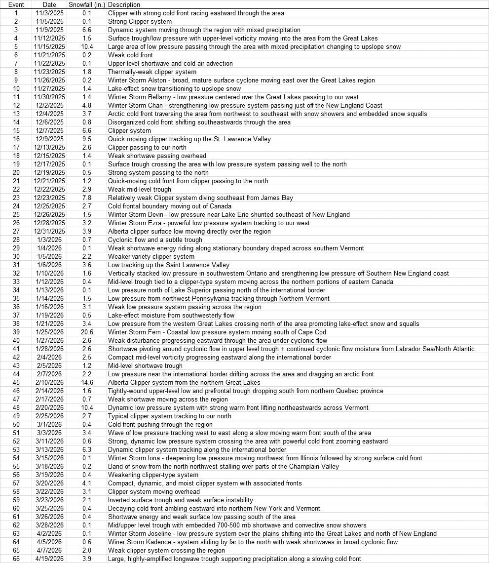
I hadn’t had a chance to put together our site’s seasonal snowfall progress update for April, but I’ve finally had some time to sum it up. The updated seasonal snowfall progression plot is below, and this season (shown in the red line) doesn’t look like it’s going to finish in there among the upper echelon of top 5 seasons. It’s certainly been a solid snowfall season though, and as you can see from the plot, it’s sitting in that zone between 2008-2009 (orange line) and that grouping of snowier seasons. The month of April itself was fairly average from a snow perspective, delivering 6 days with snowfall, 4 accumulating storms, 6.6 inches of snow, and 12 days with snow on the ground. Even though it doesn’t look like the winter of 2025-2026 is going to be a record snowfall season, I can already see that it’s going to have a number of records associated with it like the highest number of December snowstorms, highest number of March snowstorms, etc. And on that note, it has now set the record for the greatest number of accumulating storms at 66. This beats out the previous record of 64 storms held by the 2018-2019 season, and this season’s detailed winter storm list to date is provided below: We’ve only had a trace of snow at most this May, so there’s nothing new to add to the season total, but I’ll do a full season report when we get to June. The data from my last report indicated that the season was looking to end up in the range of 180-190” of snowfall, and indeed that’s right where things stand. The odds of ending up in that range are now near 100% I checked where the Vermont ski areas stand for season snowfall, and the north to south listing of totals is below. The resorts along the spine of the Northern Greens all surpassed the 300” mark, and Jay Peak exceeded 400”. That’s certainly decent, but fairly typical and nothing near record breaking. Being around 300” is average for those resorts, aside from Jay Peak where the average is ~350”, so they were definitely a bit ahead of the game since they surpassed 400”. Most of the rest of the resorts saw <200” of snowfall, which is not uncommon for the southern resorts, but is below average for some of the central resorts. Jay Peak: 410” Burke: 173” Smuggler’s Notch: 312” Stowe: 310” Bolton Valley: 307” Mad River Glen: 192” Sugarbush: 234” Pico: 195” Killington: 195” Okemo: 129” Bromley: 178” Magic Mountain: 112” Stratton: 153” Mount Snow: 130”

-
Boomer developing NW and western nj. While out on a training day for work. Gorgeous weather from bay head to belmar nj. Beautiful ocean breeze kept temps diwn a bit but once further inland it was brutal. Got up to 97 in red bank, nj.
-
Yup. My 5pm Gaithersburg to Reisterstown drive should be long.
-
Did somebody say cold front? All I feel is a gentle breeze with a few clouds passing by on another fine mid 80s afternoon! We take and bake, no questions asked!
-
I didnt hear no bell
-
Commute home looks entertaining
-
Several LSRs out of Frederick County, MD. Looks like they were the "winners" today.
-
Random TW from RLX near Charleston, WV


.thumb.gif.f92b16c631a1d15d405ed77b33f0710d.gif)