All Activity
- Past hour
-
No discernible impact from slightly less sun angle July is the warmest month climatologically even though the days are getting shorter. This has to do w/ the Earth's heat balance, and the lag that exists in the atmosphere and ocean. 1 month lag for the atmosphere and 3 months lag for the oceans as to max avg temps.
-

Fireworks Heat Contest W 7/1 - S 7/4 for Five MA Airports
southmdwatcher replied to nw baltimore wx's topic in Mid Atlantic
Just entered -
Fireworks Heat Contest W 7/1 - S 7/4 for Five MA Airports
southmdwatcher replied to nw baltimore wx's topic in Mid Atlantic
DCA 100, 103, 105, 100 BWI 100, 104, 106, 99 IAD 99, 103, 105, 98 SBY 97, 102, 105, 103 RIC 100, 104, 105, 101 Total sum rain 1.26 -

Fireworks Heat Contest W 7/1 - S 7/4 for Five MA Airports
nw baltimore wx replied to nw baltimore wx's topic in Mid Atlantic
Thanks for the entries. I double-checked the data, but I know me, so I'm sure there's a mistake somewhere. Check your entries and let me know if I screwed up.
-
It would be nice to actually get some afternoon and evening storms the next few days, though I’m not sure it’s gonna happen atleast where I am
-
I'm actually not 100% sure what you're referring to, lol
-
 It will be a day of lots of 97-99 readings.
 -
 Turned on AC for first time this evening. Getting soupy out there...70/69. Let's get that MCS later...trajectory looks good but expecting it to fizzle approaching the coast.
 -
 BOX Point & Click is 104 now for the western part of Enfield on Thursday. I'lm thinking a few less.
 -
Yeah could be feast or famine. Hopefully a couple of big boys. Could have like a +4 month but if you somehow sneak in a MECS or HECS it feels pretty good.
-

2026-2027 Super El Nino
PhiEaglesfan712 replied to Stormchaserchuck1's topic in Weather Forecasting and Discussion
If the monthlies still say cold when get to the fall, then that's the time to start paying attention. I know strong and super el ninos usually mean warm winters, but if the monthlies are still showing a cold signal for winter in the fall, then you know something is up. -
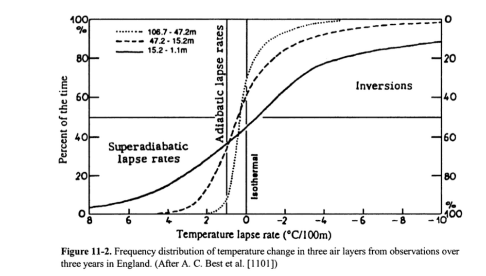
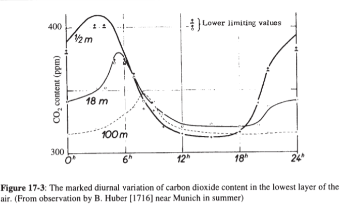
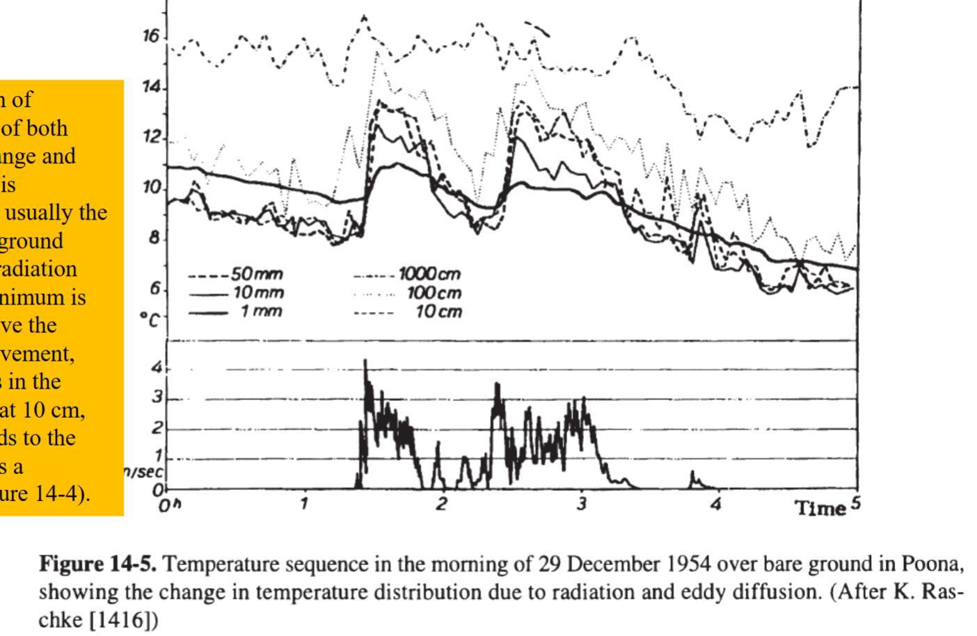
My original post was more concerned with the microclimatology that takes place near the ground during strong surface heating or radiative cooling. Agree that the function and possible inaccuracy of thermometers is important in this discussion, but the variation near the ground is amazing regardless. Below is a page right out of my textbook from last semester! Look at the frequency of super adiabatic lapse rates or inversion near the ground! Only around 10% of the time in the lowest 15 meters of the atmosphere are the lapse rates "normal" in our human range. The difference in air temperature between the street and the rooftop of a several story building could be several degrees C. Therefore, I think its fair to question how representative our 2m standard is. Additionally, this problem is exacerbated at nighttime when temperature inversions develop without strong eddy diffusion to disrupt the inversion sublayer. The graph below shows how much temperature variations exists right beneath our noses! Within the lowest 1m of the atmosphere we can see a temperature variation of 3 degrees Celsius. Then the difference 1m to 10m is another 4 degrees Celsius under calm conditions. These discrepancies matter! The lowest segment of the boundary layer that humans inhabit are defined by rapid changes with height. Take CO2 PPM as an example of the practical effect of this microclimate, a sensor at 2m is a great data point, but does it really represent the CO2 available to crops growing on fields? It is important to remember that our standards are just that: standards. They are abstractions that always leave some part of reality behind. When making decisions about heat, frost, drought, or other atmospheric events the local microclimate must be kept in mind. As a closing example, take a pool deck in the summer. Say the standard 2m temperature is a heat advisory on its own. The pool deck may instead reach extreme heat criteria as the latent heat flux of the pool water increases humidity and hot concrete deck makes the effective temperature to children, who are only a meter tall, significantly hotter than anticipated. The point of this and my previous post wasn't to say that the 2m standardized station isn't useful, nor was it to imply that the science behind our tools is not important. It was to instead clarify that these microclimates near the ground are extremely important in their own right and must be considered for effective decision making.

-

2026-2027 Super El Nino
GaWx replied to Stormchaserchuck1's topic in Weather Forecasting and Discussion
If we stick to just high end moderate/strong/super Nino fall/winter peak with +QBO Dec, Dec was warm in all 5: 1957, 1982, 87, 94, 2015. Therefore, I think warm Dec is notably climo favored as of now. 1997 is neutral QBO, not +QBO. So, it doesn’t need to be considered. -

2026-2027 Super El Nino
raindancewx replied to Stormchaserchuck1's topic in Weather Forecasting and Discussion
The Canadian run is actually pretty cold most of the US in the winter. The look is -WPO ish. We haven't really had a big El Nino with a -WPO. The El Ninos starting in 2023, 2019, 2018, 2015, 2006, 2002, 1997, 1987, 1986, 1982, 1972, 1968, 1965, 1957, 1951 are neutral/positive WPO net. The El Ninos starting 2014, 2009, 2004, 1994, 1991, 1977, 1976, 1969, 1963, 1958, 1953 are neutral/negative. 1982 was +WPO early, -WPO late winter (Dec v Feb) but mostly positive. 2009 is the strongest -WPO El Nino DJF, but even then its driven by a strongly negative -WPO in December. For the stronger El Ninos (1957-58, 1965-66, 1972-73, 1982-83, 1991-92, 1997-98, 2015-16, 2023-24), the -WPO months are: Dec 2009, Feb 1992, Feb 1983, Feb 1958. A lot of La Ninas in the South/Southwest are predominantly warm with sharp, brief cold shots - think all the recent snow down to the Gulf Coast, Texas in Feb 2021, etc. I'd expect a similar type of thing this year, but for the Northern US - predominantly warm with sharp, brief cold shots. The southern US should see mostly 'weak' cold but with brief sharp warm ups. -
 Thanks. If ORH can hit upper 90s, we're looking at real deal heat.
 -
 Can't plot MaxT for 18z for whatever reason, but a few for Thu... MHT 102 CON 101 BAF 103 OWD 103 BED 102 BOS 101 ORH 97 BDL 103 HFD 101 EWR 104 LGA 103 PHL 103 BWI 104 DCA 103
 -

2026-2027 Super El Nino
Stormchaserchuck1 replied to Stormchaserchuck1's topic in Weather Forecasting and Discussion
Not sure it's as sure as that. Everyone is jumping on like that 5/5 were warm in some skewed logic of Super being a different entity from Weak. I think -SLP in the warm season that we have going now 60-90N supports more Winter -AO. There is a global temperature jump happening I think and that could bring Winter warmer just about everywhere, but I don't it's as ENSO-related as people think. - Today
-
I was in Davis recently and I looked up Davis’s all time record high and it said 89. Is that accurate? If so, that’s crazy.
-

2026-2027 Super El Nino
MJO812 replied to Stormchaserchuck1's topic in Weather Forecasting and Discussion
Even though this winter looks mild , im looking forward to the active STJ. -
2026-2027 Super El Nino
MJO812 replied to Stormchaserchuck1's topic in Weather Forecasting and Discussion
Thanks Nostradamous -
Its July 1 LOL
-
It was groooosssss today. 86-87/73-74 all afternoon. Very high DPs for this area. Also, looking solid Thursday for our first 90+ here.
-
Even though this winter looks mild , im looking forward to the active STJ.
-
I think any regular knows my position. I won’t say it again to not trigger Maestro.
-
Like.. Restraints on power usage?


.thumb.JPG.418e8a9a2902ae687ec35ff4bc0e038e.JPG)
