All Activity
- Past hour
-

Late February/Early March 2026 Mid-Long Range
Stormchaserchuck1 replied to WxUSAF's topic in Mid Atlantic
Models have really come around to a better looking Pacific.. - Today
-
Outta gas and Outta Time: Early March Winter Storm finale
Stormchaserchuck1 replied to Ji's topic in Mid Atlantic
Yeah, but this is the 500mb pattern, super unfavorable on large scale as a sustained thing, it's taking a few days to change the surface. -
2026-2027 El Nino
Stormchaserchuck1 replied to Stormchaserchuck1's topic in Weather Forecasting and Discussion
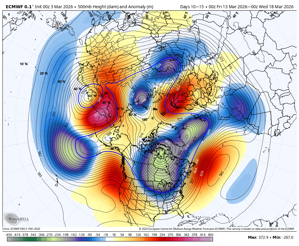
Thank you donsutherland for Phoenix, AZ statistics.. this was their warmest Winter on record by a lot. The difference between 1 and 2 is almost the same as 2 and 20. Climate analog point - the pattern that follows April-June of the analogs is below, notice the -H5 up north and -PNA in the Pacific. I've seen this when DC hits a record Winter high temperature or some other US city, the Polar area gets negative anomaly, and there is more ridging at the mid-latitudes +months forward: April US Temps (+2-4 months, some progression east) -
-

Late February/Early March 2026 Mid-Long Range
Weather Will replied to WxUSAF's topic in Mid Atlantic
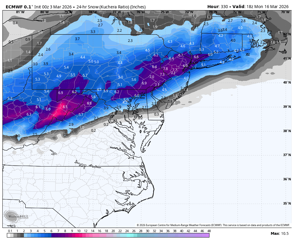
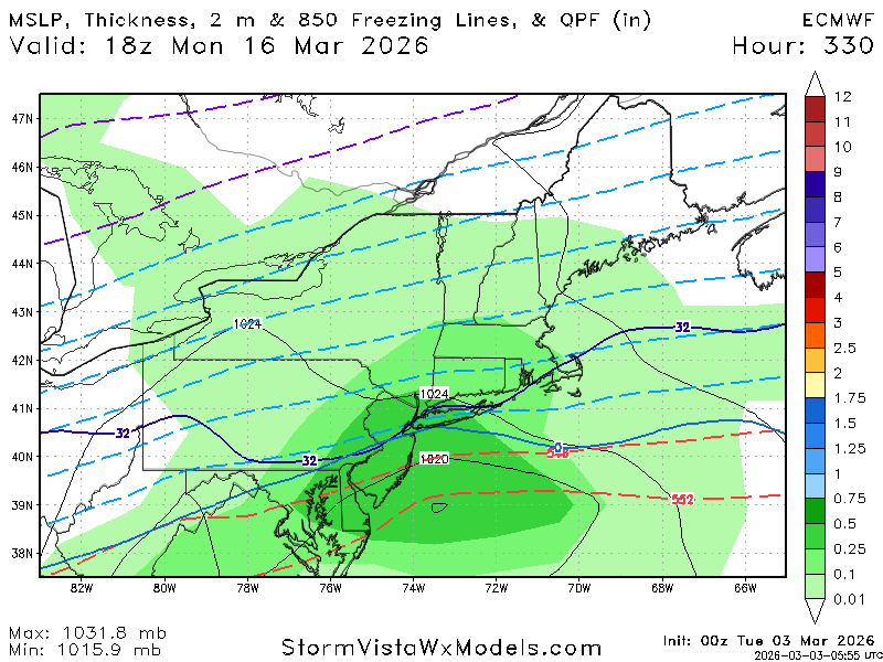
WB 0Z EURO gives us two waves of digital snow to watch. Only 13 days of tracking to go.....


-
Too bad its weenie land
-
30 here
-
Down to 10
-
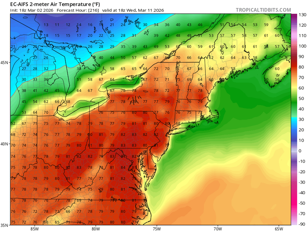
I remember March 2016 we hit 81 on Mar 9th and then got a 4-6" snowstorm on Mar 21st and 2 more snow/ice storms in early April. It's a wild month.
-
Seasonal snow to date: 14" 12/5: 1.75" 12/14: 1.0" 1/24-25: 8.5" 2/22-23: 2.0" 3/2: 0.75" I think I'm good for at least one more 0.5". Maybe a sloppy car topper on April 11th
-
each and all happy
-
70's-80F to snow - LFG
-
=)
-

-

Central PA Winter 25/26 Discussion and Obs
Ruin replied to MAG5035's topic in Upstate New York/Pennsylvania
I kind of feel it was way colder then this -
Forecast calling for a high of 86 here next Tuesday 3/10. I don't know what the record for that day is in Atl. but I imagine 86 would destroy it if true.
-

Outta gas and Outta Time: Early March Winter Storm finale
SnowenOutThere replied to Ji's topic in Mid Atlantic
Spoiler alert it’s freezing drizzle to my eyes -
I recently looked at the SREF on the SPC web site, like last week or something. There is a big thing that said the SREF will be discontinued later in 2026. After posting this on a different weather discussion forum, I've been informed that the NAM is going to be discontinued at some time. Here is a statement released in 2025. https://www.weather.gov/media/notification/pdf_2025/pns25-41_RRFS_legacy_model_cessation.pdf other information from 2025 https://www.weather.gov/media/notification/pdf_2025/pns25-73_Proposed_Termination_NAM_MOS.pdf I thought the NAM would keep going forever, as it has been known as the premiere mesoscale model for the USA. I was thinking that it feeds the 3-km NAM with boundary data and/or some other important data. Apparently not. I'm a little confused as to what convection-allowing model(s), other than the NAM, might disappear and appear in the PivotalWeather and other web sites. A little piece of me says, yeah when the GFS says of 500 J/kg of CAPE at the location of the next big severe weather outbreak, then you turn to a model that will actually calculate the CAPE. (Am I crazy?)
-
Low of 45, high of 54 and remained cloudy all day.
-
Well now it is the GFS, ICON, UK, and Euro all have the CAD signature, at least for my neck of the woods up here in Northern MD.
-
It appears by the end of this year, Rio de Janeiro will be made a TCAC for the South Atlantic Basin. https://x.com/frontierfcst/status/2028252178335310228 Now only if we could get a TCAC for the Mediterranean Sea, which clearly has shown that it has bona fide TCs, along w/ many subtropical cyclones. Geopolitical borders/areas are a construct of human society. The atmosphere does not care one bit about that. It does what it does regardless. This system is I think the strongest Mediterranean Sea TC on record - Ianos Sep 2020. https://en.wikipedia.org/wiki/Cyclone_Ianos tcac.pdf
-

Outta gas and Outta Time: Early March Winter Storm finale
87storms replied to Ji's topic in Mid Atlantic
So basically I don’t know what form of precip the next round will be lol. -
80?