All Activity
- Past hour
-
Not yet. Our shallow well's reserve is usually ~500 gallons (5 ft deep in the tubs). In 2001, our driest year here, it was below 300 and dropping, until late fall. CON is +4.8F on the highs and -1.1F on the mins. Yore heat Similar here: +5.5 and -0.8
-
gets it to 914
-

Hurricane Erin - 75 mph - 996 mb - WNW @ 18
Wannabehippie replied to BarryStantonGBP's topic in Tropical Headquarters
Erin trying to clear out the last of the dry air preventing it from some rapid intensification. http://blob:https://www.tropicaltidbits.com/aab02ef8-e81f-4556-8126-6b2fcb614b60 -
 Here are the standardized scores for Central Park. I used the same criteria as for JFK Airport.
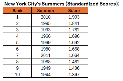
-
I'm missing jburns
-
Only 0.02 for the month to date.... following a big July.. Grass looks the best its looked in a couple months though, brown moldy spots disappearing... Streams coming out of the southern National Park in both eastern Augusta and western Albemarle are running very low though - especially since its August and everything is still green/growing and using water...
-
1 For sure! The CoCoRaHS observations for the last 30 days. That's me with the 0.90" in Frederick. Your area looks well watered
-
It would, though.
-

2025 Atlantic Hurricane Season
BarryStantonGBP replied to BarryStantonGBP's topic in Tropical Headquarters
-
yeah.. it's interesting following these atmospheric indices as I do. Yesterday, an early autumn 'shot across the bow' type pattern was coherent in both the numerical data, but also in the synoptic/spatial layouts, from all three ens sources GGEM/GEFS/EPS. I posted about it... that's normal. If your goal is to not materialize a pattern you want, all you have to do is mention it. Boom! wanted pattern summarily breaks heart. This is why you should never tell a woman how you actually feel... No but since then the numerical side of that have pushed a new -PNA/-EPO tandem out there between D10 and 14. Then, the operational runs overnight sort of half committed; the Euro and GFS proper having some suggestion, which fits that tandem. We'll see. It's harder and harder anyway to determine that particular week any given season, when the season tries to pick up more than it can handle and cracks haha. Seriously, CC is seriously f*cking that orderly expression ( in time ) from happening as dependably as it did for grand pappy. We'll get a frost on Sept 10 and then 90 for 3 days on 15th... just sayn'
-
Hurricane Erin - 75 mph - 996 mb - WNW @ 18
BarryStantonGBP replied to BarryStantonGBP's topic in Tropical Headquarters
OI LADS GTFIH NOW I JUST SAW THIS WHILE IN SPOONS LASSIE EXPECTED TO BE A CATEGORY 4 FORECAST POSITIONS AND MAX WINDS INIT 15/1500Z 18.2N 56.1W 65 KT 75 MPH 12H 16/0000Z 18.9N 58.4W 75 KT 85 MPH 24H 16/1200Z 19.8N 61.4W 90 KT 105 MPH 36H 17/0000Z 20.6N 63.8W 105 KT 120 MPH 48H 17/1200Z 21.6N 66.0W 110 KT 125 MPH 60H 18/0000Z 22.7N 67.9W 115 KT 130 MPH 72H 18/1200Z 23.8N 69.2W 120 KT 140 MPH 96H 19/1200Z 26.5N 70.8W 115 KT 130 MPH 120H 20/1200Z 30.3N 71.0W 110 KT 125 MPH $$ Forecaster Beven -
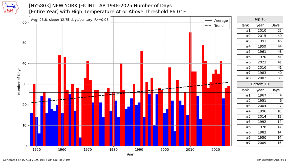
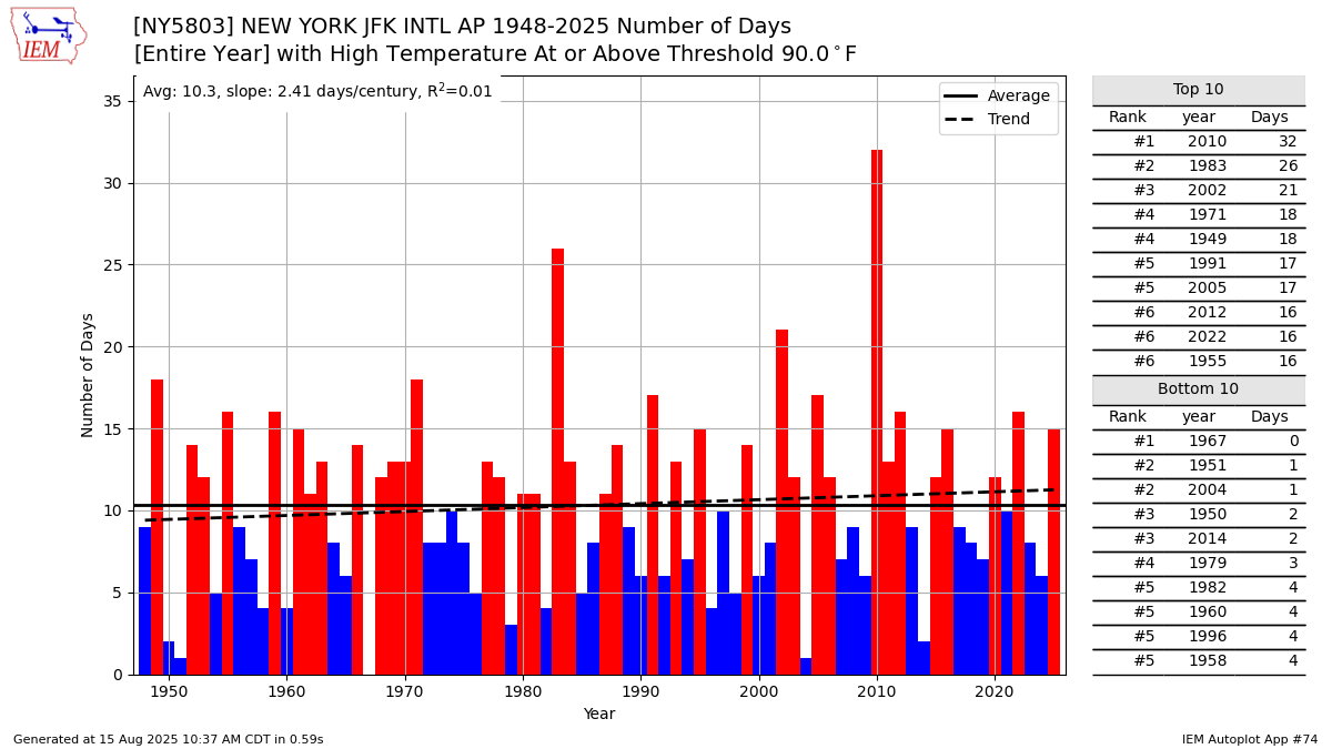
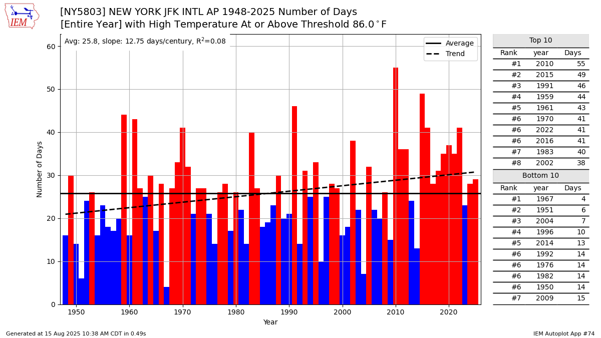
 90° days have been increasing at a slower rate than the 86° days at JFK. If the summer high temperatures rise another 2-4°, then the 90° days will begin to increase more sharply. The summer average high is still too low for a big increase in 90° days like areas west of the sea breeze in NJ have experienced.
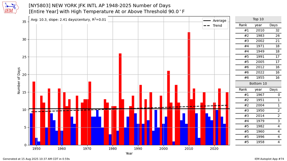
-
I don't think people realize how hard it is to get true CVs this way. Not just here in New England, but the entire U.S. coastline. I went back the other day and ran some numbers. Since the start of our exceptionally busy period of Atlantic activity in 2017, there have been 157 named storms in the basin. Only 19, or 12% of those systems, have been CVs--which I defined as developing within about 5 degrees of the Cabo Verde Islands. Of those 19 CVs, only 3 (16%) have impacted land. Irma in 2017, Florence in 2018, and Larry in 2021. Now, to the point that some have made, Florence and Larry were infamously locks to go OTS before they weren't, but statistically that's rare. CVs that made landfall accounts for just 1.9% of all the storms that developed in the 2017-25 period. It takes an extraordinary set of circumstances for CVs to hit the US.
-
cicadas?
-
That sounds stunning and absolutely amazing, did you get to see a rainbow too? I had a similar situation on July 3rd and captured a stunning double rainbow with purple skies. That almost happened with this storm, but the sky was too dark and the beginnings of the rainbow looked pale and almost a light pink color against the purple skies.
-
wow JFK is very different from here, I finally hit 90 yesterday at 3 pm for the first time this week!
-
.thumb.png.df5d4621c1f2821dab4f63e18888ecaf.png)
-
Big shift west hopefully the better models do also
.thumb.png.5eebcd924fdda7348d4d090f53cae7ca.png)
-
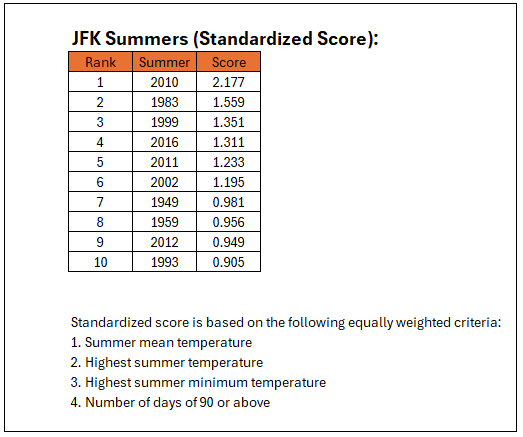
 Thanks Don, I figured as much, 1948 was not very hot outside of that extreme heatwave near the end of August (I wonder why it happened, there must have been some very anomalous pattern in place. The only other time NYC had three 100+ days in a row was in 1993 and that was a hot summer from beginning to end, very different from 1948.) Don, when you have some time could you do a chart like this for NYC too? I think the top summers would be 2010, 1993, 1953, 1949 and 1983.
 -
 Who knows. My neighbor 2 doors down has 3 show dogs (smooth collies). For some reason, she has them outside all the time and they bark at everything. It is so annoying. There is no reason why 70 pound dogs need to go out every few hours.
 -
.thumb.png.d9671c233f2ee3469207f01b42e2579c.png)
-
It's highly unlikely. Both LGA and Central Park had too few 90° or above days during 1948 and the summer mean was 0.4°-0.5° below that of 1949. Using just the 1948-2024 period, 1948 ranked 13 spots below 1949 at LGA and 19 spots below Central Park.
-
86/70. It's going to be a little warm at great adventure.
-
Maybe they're barking at some animal outside that they hear or smell but humans can't? edit-- oh you mean there are dogs outside they're barking at?
-
Its really close


.png.0cc1eb4fc194266c4053ec96c1b14743.png)
.png.6151ca091d04c960e0abc0edc90ca35b.png)

