All Activity
- Past hour
-

First Legit Storm Potential of the Season Upon Us
The 4 Seasons replied to 40/70 Benchmark's topic in New England
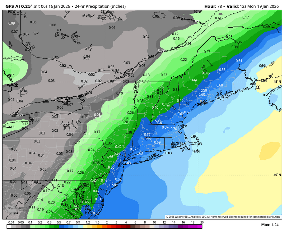
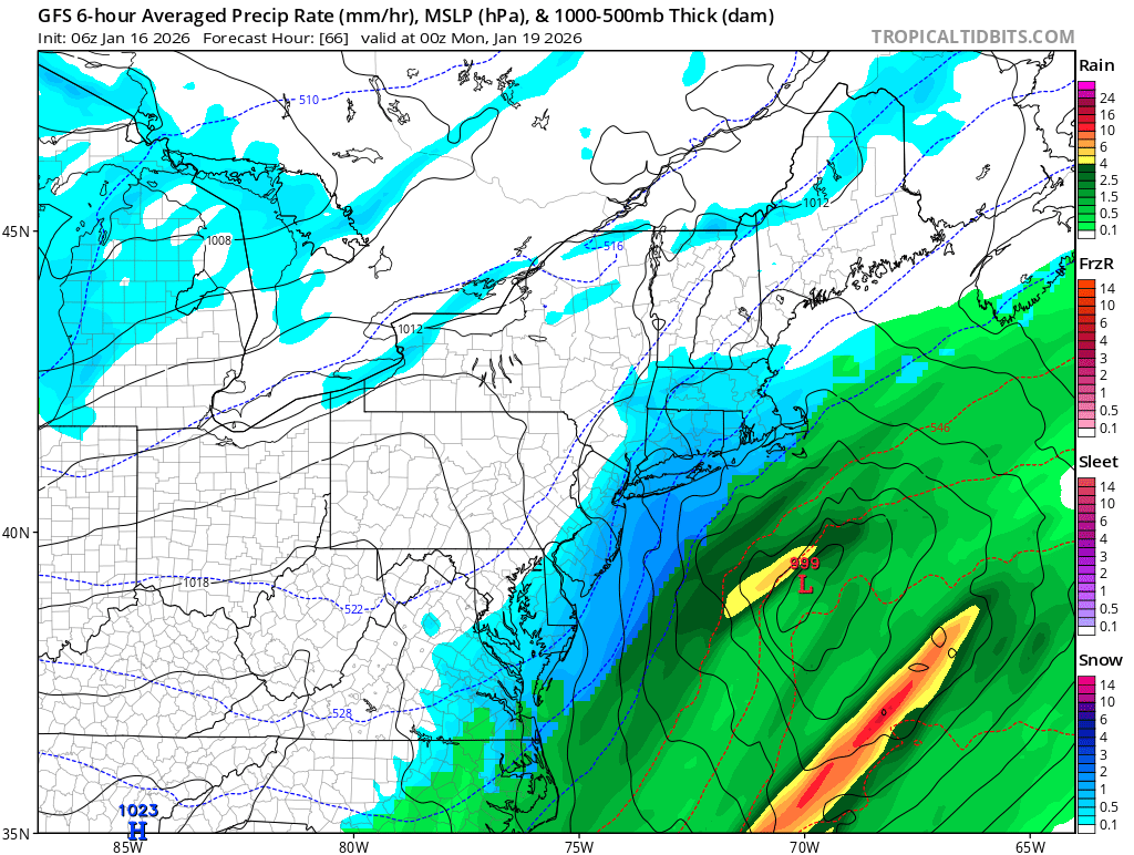
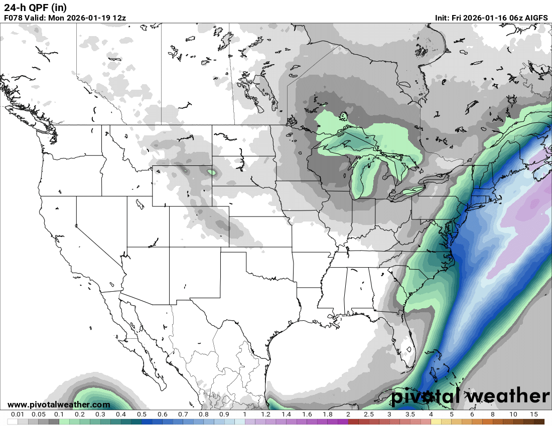
and that doesn't include saturday, thats 24hr qpf. -
First Legit Storm Potential of the Season Upon Us
The 4 Seasons replied to 40/70 Benchmark's topic in New England
GFSAI 6Z would be warning snows back to the NY boarder...another good bump NW and beefed up is the takeaway though 00Z AIFS also bumped NW good trends along with the 6Z GFS. EC/EPS still the farthest se but going in the right direction just need to see more from that camp, besides the AI stuff.
-
First Legit Storm Potential of the Season Upon Us
The 4 Seasons replied to 40/70 Benchmark's topic in New England
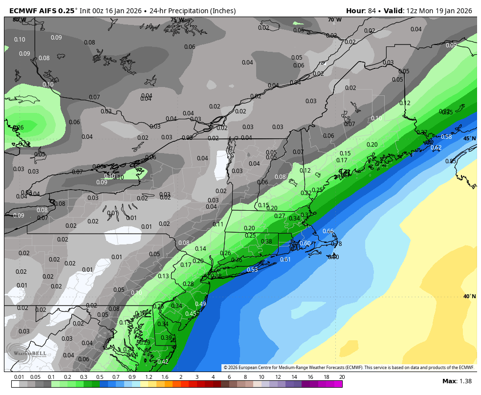
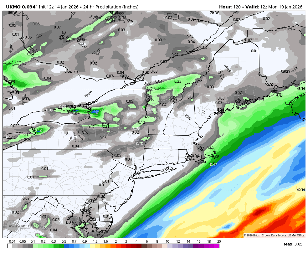
00Z ukmo for some laughs..
-

First Legit Storm Potential of the Season Upon Us
WinterWolf replied to 40/70 Benchmark's topic in New England
Lol…I was like wow, he actually posted something that wasn’t a rant. Refreshing. -
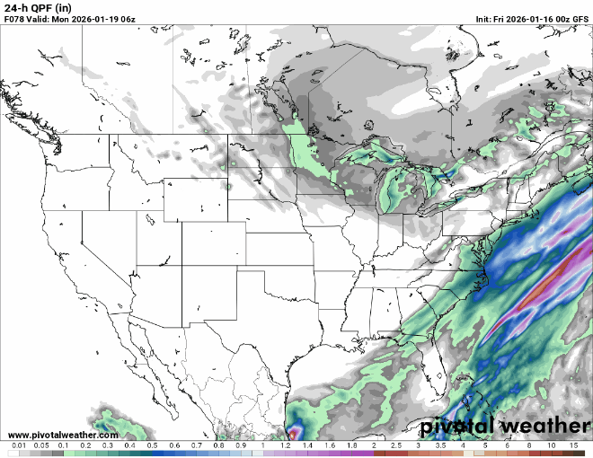
gfs and euro still worlds apart for Sunday. We need those recon flights yesterday haha
-
First Legit Storm Potential of the Season Upon Us
The 4 Seasons replied to 40/70 Benchmark's topic in New England
it's over, it's done pack it in. -

Central PA Winter 25/26 Discussion and Obs
mahantango#1 replied to MAG5035's topic in Upstate New York/Pennsylvania
-
Looks like more wintery weather tonight for the south central mountains. The Sunday system doesn't look good currently.
-

January 2026 Medium/Long Range Discussion
Stormchaserchuck1 replied to snowfan's topic in Mid Atlantic
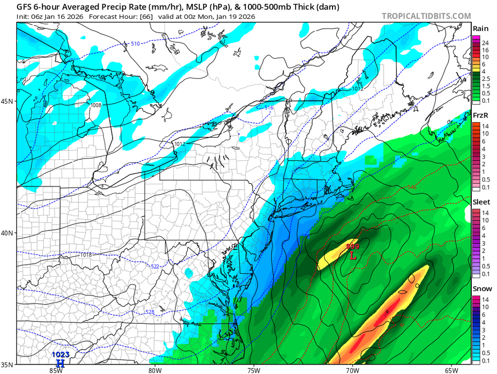
Well here's this storm.. we have a 1030mb High over the Great Lakes. +NAO is bringing the jet stream a little north though -
Models still don’t have a grasp on a storm 24 hours out. None of the 6Z line up with current weather conditions. .
-

Winter 2025-26 Medium/Long Range Discussion
A-L-E-K replied to michsnowfreak's topic in Lakes/Ohio Valley
Pure zzzzzs + East coast pattern, rough -
Notable trends west overnight. Euro OP still says no but should it cave west, will bring snow to the city. AI models holding strong. Wouldn't write anything off yet for those east of I-287 and US 202. Let's see how things evolve
-
First Legit Storm Potential of the Season Upon Us
WinterWolf replied to 40/70 Benchmark's topic in New England
Will the AI’s pull this bitch out? Dam impressive if they do. -
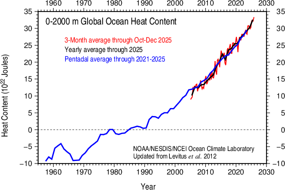
NOAA ocean heat content surged last year. Agrees with other ocean heat datasets for 2025 posted above. Another sign of accelerating warming since the hiatus ended.
-

First Legit Storm Potential of the Season Upon Us
ORH_wxman replied to 40/70 Benchmark's topic in New England
Nice shift on GFS. Still want Euro to jump W again. -
Central PA Winter 25/26 Discussion and Obs
mahantango#1 replied to MAG5035's topic in Upstate New York/Pennsylvania
DROUGHT UPDATE 7.01% of PA in D2 (Severe Drought), up 2.03% from last week Precipitation departures 2-4" BELOW normal last 60 days Drought Warning for Fulton Co, Drought Watches elsewhere Unless there's a big winter storm, drought conditions will likely persist (or worsen) -
Ai gfs got better

-
January 2026 Medium/Long Range Discussion
Stormchaserchuck1 replied to snowfan's topic in Mid Atlantic
6z GFS is a little bit of a hit. -

First Legit Storm Potential of the Season Upon Us
MJO812 replied to 40/70 Benchmark's topic in New England
Came west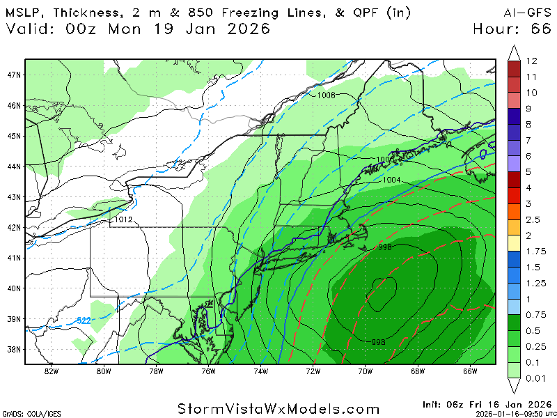
-

First Legit Storm Potential of the Season Upon Us
CoastalWx replied to 40/70 Benchmark's topic in New England
Wow great trends -
Gfs came west
.thumb.png.792bc820534bb7d65a509a171379b3a0.png)
-
First Legit Storm Potential of the Season Upon Us
MJO812 replied to 40/70 Benchmark's topic in New England
Gfs got better.thumb.png.4707c26341462f5de484cd392987f9d1.png)
-

First Legit Storm Potential of the Season Upon Us
ineedsnow replied to 40/70 Benchmark's topic in New England
AI GFS got way better also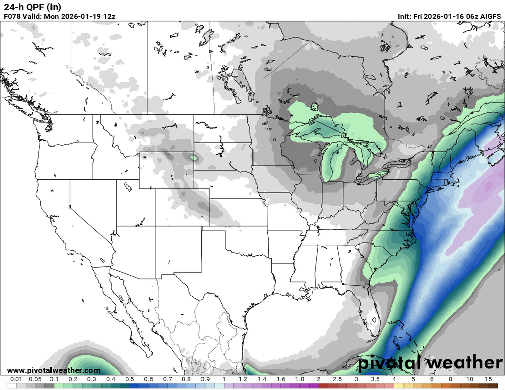
-
First Legit Storm Potential of the Season Upon Us
ineedsnow replied to 40/70 Benchmark's topic in New England
-
First Legit Storm Potential of the Season Upon Us
ineedsnow replied to 40/70 Benchmark's topic in New England
.thumb.png.d69bdd24798d0f0965e30e43a8d9b071.png)


.thumb.jpeg.f5c6ba9d911ec96b3b124f8606aee58e.jpeg)


.png.b80f58ced2c6ed08953fe0a1887e0958.png)
.png.fc8910107ead7afb63f7fa867905b76c.png)
.png.f8fe65f25b602927ad2ed250c9556b37.png)