All Activity
- Past hour
-
Sucky offense...defense is what kept us in it.
-
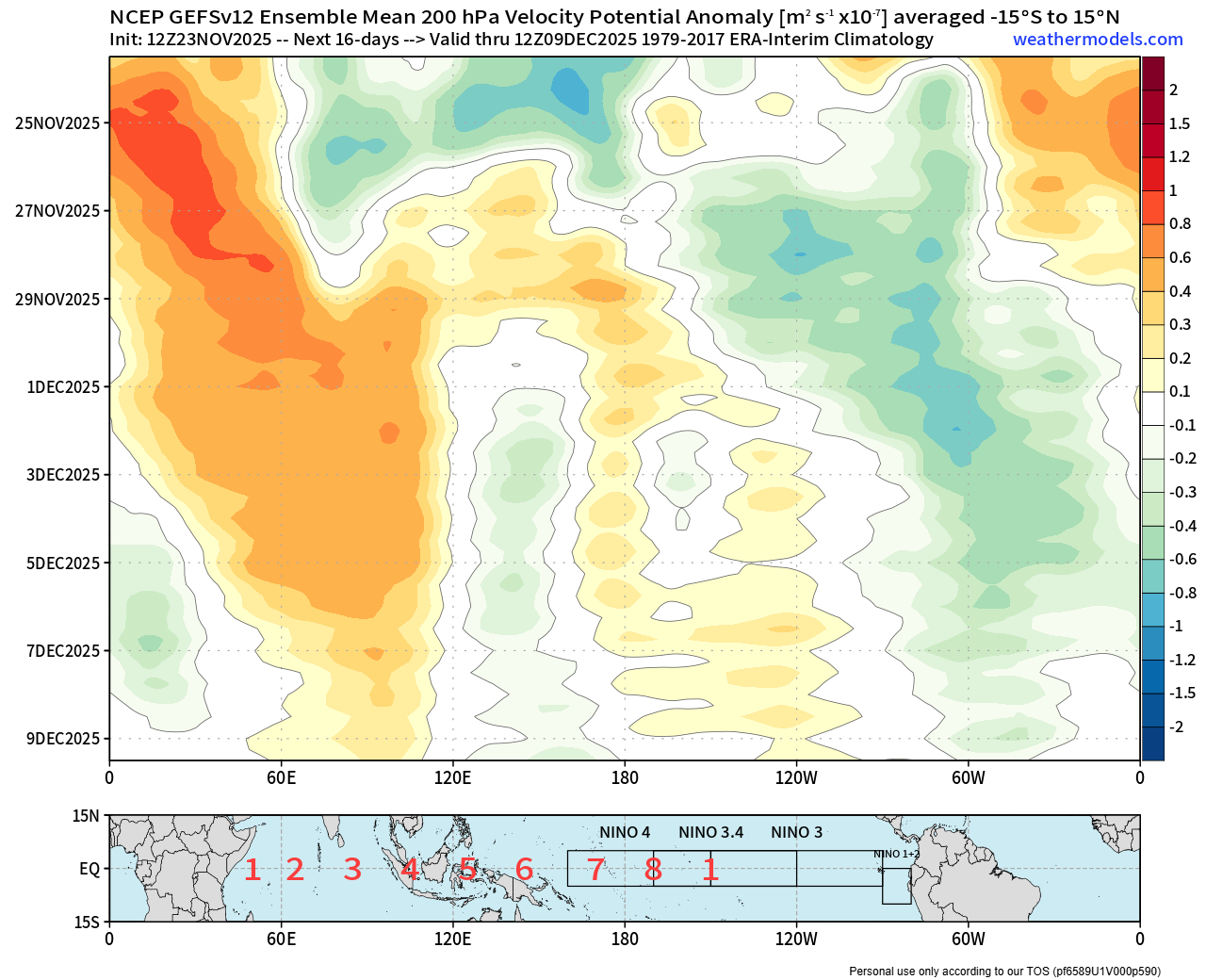
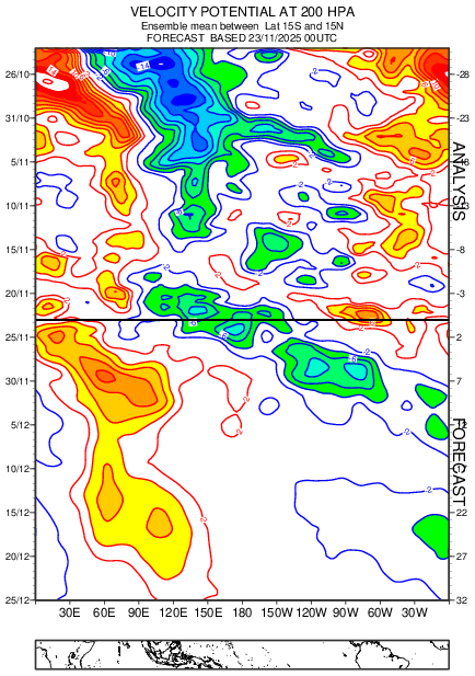
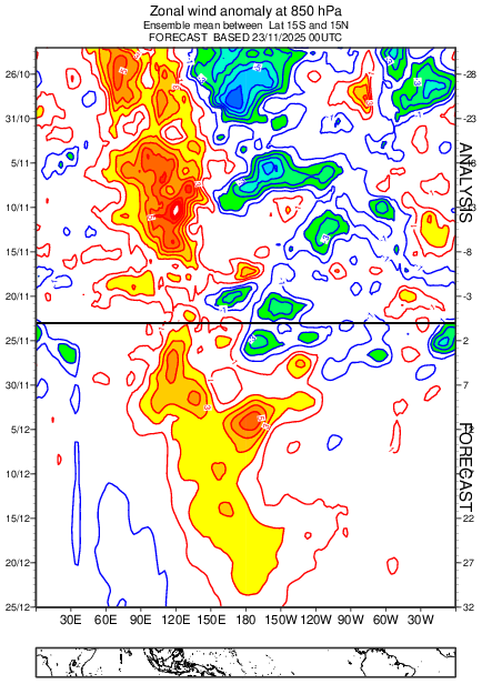
Nice post man. You know that I agree with this assessment. We've had some good chats about this occasionally in past years. It's a real factor and should be considered into the equation. Having said that. I don't think we should rush to judgement yet on this particular MJO event and I'll try to explain why. This event thus far has been driven to propagate eastward with CCKW's. Which operate due to different circumstances from the MJO and with much faster timescales. Since the beginning of this event really, they've been noticeable in the data and the models. I mentioned this phenomenon in a post here last month I think too. This is still the case on current runs. We've been seeing this alternating constructive and destructive interference cycling through the event as they do. Which is presenting itself as the loops around on the RMM charts we've been seeing. It was slowed, naturally, as it approached the La Nina state in addition to that as well. However, it seems to want to persevere on the longer range guidance. Regular ensemble runs (gefs/eps) don't run out far enough to capture the whole picture. What we've been seeing with those is an amplified trend when there is constructive interference. Mixed with other times where the signal almost vanishes when there is destructive interference from these CCKW's. The latest one is about to constructively interfere, which is offering some boost to the Phase 7 signal upcoming. Some here seem to be under the impression that the phase 8 attempt is within range of the current medium range ensembles. I think that is a mistake. Any signal giving that impression should be the current CCKW continuing to propagate through to the east. So what I think will happen, is that we will see the amplification into phase 7 as guidance is advertising. Followed by a degradation which will be denoted once again with the RMM chart doing a loop with the signal again. IMO the actual attempt for the push into phase 8 comes a little after that. With the next CCKW that should propagate through and is modeled to do so. If guidance is any indication, that should occur close to mid month in December IMO. Outside of the range of current gefs/eps runs. We'll probably see a more ambiguous signal until that time. Much like the later stages of the 12z GEFS posted right below. It could in fact fail and possibly for the reasoning that you've laid out very nicely here. Personally I think the jury is still out for this one, but that they will enter the building around mid December to prepare the verdict. Such as euro (and gefs for that matter) weekly data suggests. Today's euro weekly forecast at the very bottom. Today's Euro weeklies VP200 followed by U850:

-
 About 2 mins of flurries today
 -
Careful, we don’t want the nina to fade too fast. Winters with a nina that quickly fades to neutral by Jan tend to be less snowy than those that fade more slowly.
-
.thumb.png.4150b06c63a21f61052e47a612bf1818.png)
November 2025 general discussions and probable topic derailings ...
HIPPYVALLEY replied to Typhoon Tip's topic in New England
You joke, but definitely a possibility. -

2025-2026 ENSO
michsnowfreak replied to 40/70 Benchmark's topic in Weather Forecasting and Discussion
The last week of November actually got colder on the weeklies. And has for several days. Though I know youre concentrating on December. I know the Mid-Atlantic may not like it but those weeklies with the cold to the Nw and warmth to the SE would be a great storm track for the Great Lakes. -
Strongly disagree. Apps and websites featuring questionable sourced weather information abound. Local, trusted media and meteorologists are needed now more than ever. Take Windows 11 for example. I get push notifications for Rockville, MD for tomorrow on my work laptop that it's going to be a high of 4° degrees tomorrow. How is this even remotely accurate?
-
 Same here. It’s cute.
 -
i know, right? to my delight i saw the "HOT" thing and i thought we were getting hyped, and then i read about last rites for december in fucking november. wtf are we doing yall?

-
Im so bummed that the cold in December is already over even though it isn't December yet. Some of these guys are 15 years old or act like it. Makes this place unreadable just like my Vikings are unwatchable.
-
pretty decent signal for a rainstorm around nov 30-dec 1. maybe some energy can sneak past the mountains on the 29th while the cold air is still there for some tv snow
-

December 2025 Short/Medium Range Forecast Thread
Carvers Gap replied to John1122's topic in Tennessee Valley
For clarification of my above model verification comments. @Terpeastposted this. For future reference, based on MJO verification over the last 30 days, GEFS is really the one to watch when MJO is medium to high amplitude. And it’s not even competitive. -
Just a lil ice with an incoming tropical system in the gulf

-
WTH is going on in this here thread? Maybe delete it and start over.
-
This is a terrible post. Take a break lol.
-
Nah, he just stopped taking his meds.
-
December 2025 Short/Medium Range Forecast Thread
Carvers Gap replied to John1122's topic in Tennessee Valley
Really there are two BIG things models are trying to navigate. It is going to take some time for them to "get right." 1. SSW - to what extant (if any) does this impact NA or the surface at all??? 2. The cutoffs in the SW. It sure looks like feedback after system one. I have been fooled by modeled cool forecasts for December before. Conversely, I have seen LR extended modeling show cold, reverse course to warm, and then revert back to the original cold look. So, I am gonna just "chill," enjoy the Florida beat down aftermath, and eat some great Thanksgiving food this week. We certainly could see a warm temps in phases 8-1-2. It has happened before, and could happened again. But I have also seen deterministic modeling flip very cold once they recognize the MJO phases - almost all at once. -
Just curious. Where da fu*k is Randy!? He no longer likes winter misery!? Get your ass back in here so we can all whine and bitch together.
-
December 2025 Short/Medium Range Forecast Thread
Carvers Gap replied to John1122's topic in Tennessee Valley
FWIW, the 12z GEFS looked good in terms of cold. I noticed that one of the mets in the MA noted that the GEFS is running circles around other modeling right now in the extended range. I don't have that data, and am to lazy to look...so just look in their December thread for reference. -
December 2025 Short/Medium Range Forecast Thread
Carvers Gap replied to John1122's topic in Tennessee Valley
One last note, the Euro Weeklies are very dependent upon the first two weeks of the 0z deterministic. I knew today's Weeklies would be warm. It was simply an extrapolation of the deterministic which is struggling greatly with what is likely Southwest feedback.. It would not surprise me to see them snap back cold if the MJO continues to rotate. I have definitely seen models not recognize the MJO impact until day 10-12, and we are not to that point yet. I would suggest modeling will trend much colder as it becomes clear to modeling that we are entering a phase 7-8 rotation, and I wouldn't be surprised to see it rotate right back to 6-7-8. -
man you were doing so well
-
December 2025 Short/Medium Range Forecast Thread
Carvers Gap replied to John1122's topic in Tennessee Valley
The good thing about the Weeklies.....it is still shoulder season and they apparently have missed days 1-10 of December badly - just speaking of the hemispheric long wave pattern. In other words, do we trust a model which likely is going to miss badly? The Weeklies will almost undoubtedly miss embedded cold. Models are swinging back and forth wildly right now. That tells me cold air is incoming into NA. The Mountain West looks likely simply because that has been the pattern since 2015 or so. I really doubt models are done with their wild swings. The GFS trying to "cook up" a Gulf hurricane tells us this could be wild. But really, I think the first week of December has been pretty well documented as being warm. This was a textbook kick the can or Lucy football situation. The second week of December should be a transition w/ the time around Christmas "maybe" being very cold. I also think SSWs upends thing. Within days of it being mentioned, the LR pattern went warm-ish. We have seen that occur several times. That said, I do think we have some chances upcoming. Either way, early December is rarely good snow climatology. I do think there is a bit more pressure to have cold weather in December during Nina years as they are front loaded. If Cosgrove is right, the last half of winter should be good. He certainly has stuck to his ideas and appears to be ready to score a coup of sorts for December. Again, after models missed the Baja low (multiple lows in succession), I have been waiting for the dust to settle so to speak. If the end result of this is getting a cold or seasonal air mass around the holidays...I will gladly take it. -
I'll take my chances straddling the warm/cold boundary, that's where the action can be. 60F/sunny and 20F/sunny look the exact same through my window on Christmas day.
-
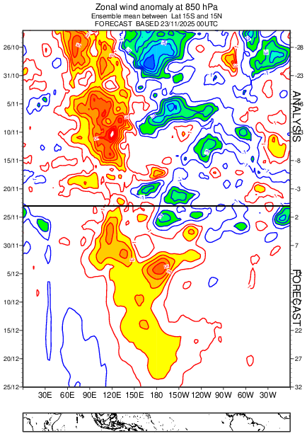
Today’s Eps again says bye-bye to the Niña by Christmas with a serious westerly wind burst anomaly at 850mb.
-
Not one model had BWI BN for November, though the Cansips was the closest while still being a bit AN. Yet, thru yesterday, BWI is -.1. After this week's cold shot, BN for the month is a virtual guarantee. So eff the back and forth of the models because this Fall has been finding a way to squash threatened warm-ups into average or below. THAT'S what's important imho.