All Activity
- Past hour
-
-EPO/+TNH is a highly volatile pattern where even a slight difference can lead to the difference between a raging SE ridge and Jan 2014 cold. IMO the pattern looks like Jan 2014 at this juncture, don't think we'll get a big dog but multiple 2-4", 3-6" events are on the table, maybe even a 6-10" event.
-
At this point I think the only real thing to note is that we have a deep trough over the eastern US and several shortwaves that appear poised to dive in over a west coast ridge which may (or may not) help amplify the broad trough into distinct storm systems. Otherwise we just have to wait and see because (and I may be wrong) I doubt this will be a great setup for models to get right with more than even 4 days in advance.
-
Good luck with that.
-
We need a surface reflection in the southeast for the Thurs. event. Otherwise it's likely light rain/warm or an offshore low. Shortwave energy and low surface pressure in the Lakes region torches our lower levels. It's a symptom of a positively tilted trof collapsing on itself. We need more PVA in the south, not the Lakes. But we are moving away from that idea.
-
Weathergeek on one end, you on the other and reality hopefully in the middle. .
-

January 2026 Short/Medium Range Thread
Weatheriscool replied to John1122's topic in Tennessee Valley
Looked pretty good for West and Middle I would say as well - I think sometimes we forget the forum is the entire state lol -
GEFS still not thrilled about the 15th.
-
Decided to finally read up my Northeast Snowstorms book now that I have the tools to understand it. Will be taking some notes and sharing them here later to help in the future tracking.
-
Apologies if it was already mentioned but GFSAI has a couple rounds of winter weather it looks like. Different solutions to all the possible events vs Ops though.
-
-
The first storm is on the table but by “on the table,” it could be a table setter for something much larger with that second storm. scoring the first would be an absolute coup, but the cmc uses it to help establish a much better environment for the second storm.
-
About to be into a serious week of tracking next week. The band's about to get back together yall. Will the tour end in success or failure....
-
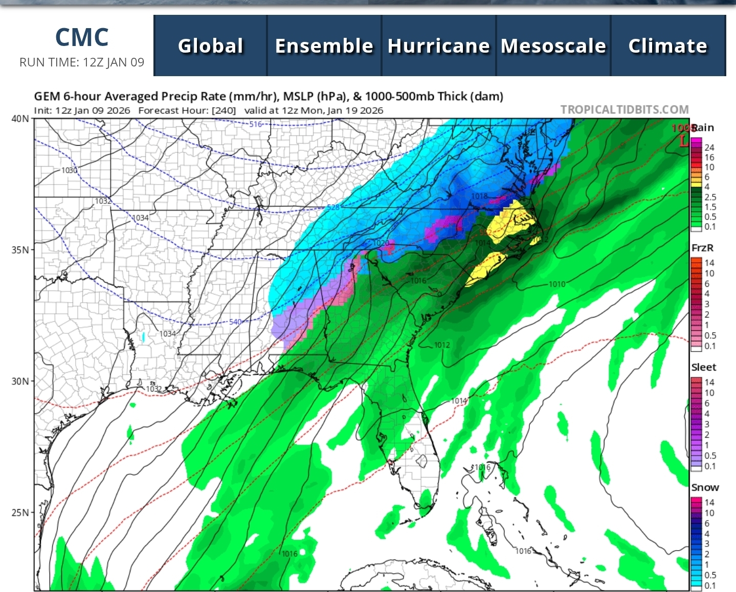
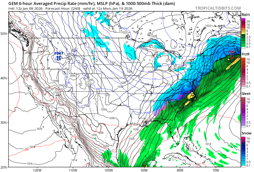
The CMC is cold fluff verbatim. Likely would've been an 8-12" deal if the run ran a little longer.
-
12z Canadian also has the banana high the GFS had. Good to see that feature on multiple models.
-
12z CMC at the end of its run

-

January 2026 regional war/obs/disco thread
dryslot replied to Baroclinic Zone's topic in New England
-
The Canadian is still snowing over the eastern half of the state at the end with temps in the single digits across the state. It's so cold the ratios are insane. Almost 20:1 in parts of the area.
-

January 2026 regional war/obs/disco thread
40/70 Benchmark replied to Baroclinic Zone's topic in New England
..but rain in eastern Mass....: -
Disappointing 12z runs. Guidance starting to converge on a miss next week just as we approach a more reliable model time frame. Ensembles have consistently shown very little snow through the end of next week. Next weekend's potential event is still in fantasy land so hard to get excited about anything that far away.
-
Full Canadian run is more for East TN as wekk and still snowing in East TN at the end. GFS also has a good hit for East TN around the same timeframe!
-

January 2026 regional war/obs/disco thread
CoastalWx replied to Baroclinic Zone's topic in New England
Might be time to lock in now -
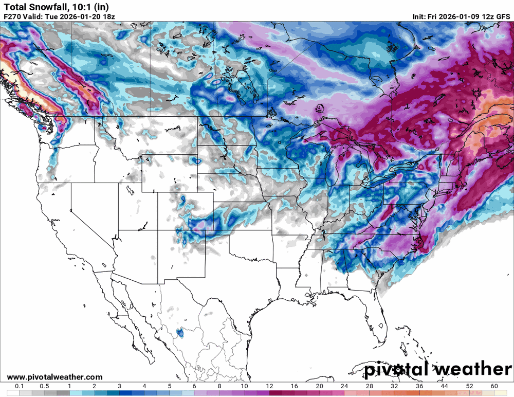
Pretty amazing depiction to get snow down to the Gulf states all the way into the Canadian Maritimes. No matter what this upcoming time period looks loaded.
-
Oh Canada!

-

January 2026 regional war/obs/disco thread
ineedsnow replied to Baroclinic Zone's topic in New England
snow from Northern Maine to just about the Gulf Coast.. not often you see that -
January 2026 regional war/obs/disco thread
40/70 Benchmark replied to Baroclinic Zone's topic in New England
Yea, I mean...those are Ginx specials since he gets off to minimum central pressure and beach erosion. All I care about is how deeply my yardstick becomes submerged.