All Activity
- Past hour
-

July 2025 Obs/Disco ... possible historic month for heat
Brewbeer replied to Typhoon Tip's topic in New England
weather is much improved this morning, windows open, 72/60. -

July 2025 Discussion-OBS - seasonable summer variability
bluewave replied to wdrag's topic in New York City Metro
The 90° reading for JFK at 10pm was pretty impressive. The all-time 10pm record high at JFK was 95° set back on July 5th 1999. So anytime we are near 90° this late into the evening people notice since it close to the record values. This allowed the record low max at ISP set earlier in the day to hold. A 79° low for anywhere in Suffolk County is very impressive. You can see it beat the previous record by +4°. The warmest low max ever at ISP was 81°. RECORD EVENT REPORT NATIONAL WEATHER SERVICE NEW YORK, NY 316 AM EDT FRI JUL 18 2025 ...RECORD DAILY HIGH MINIMUM TEMPERATURE SET AT ISLIP NY... THE LOW TEMPERATURE WAS ONLY 79 DEGREES THURSDAY, JULY 17 AT ISLIP MACARTHUR AIRPORT. THIS BREAKS THE OLD RECORD HIGH MINIMUM OF 75 DEGREES, LAST SET IN 2021. RECORDS FOR THE ISLIP NY AREA GO BACK TO 1963. ALL CLIMATE DATA ARE CONSIDERED PRELIMINARY UNTIL REVIEWED BY THE NATIONAL CENTERS FOR ENVIRONMENTAL INFORMATION (NCEI). -
The record WPAC warm pool and cooler waters east of the Dateline have been driving these stronger EWBs. So the actual Nino 3.4 SSTs aren’t that important. It’s the SST difference driving the La Niña background. This was the strongest early July EWB near the Dateline since 2022 but not quite as strong.The RONI also tries to approximate this difference which keeps this persistent La Niña background going whether the actual Nino 3.4 is closer to neutral or below -1.
-

July 2025 Discussion-OBS - seasonable summer variability
SACRUS replied to wdrag's topic in New York City Metro
76 / 64 and mostly cloudy. Partly cloudy forecasts look optimistic. Cooler / drier - likely a break in the 3/4 day heatwave for many, enough sun could get the hottest spots inland there but it looks cloudy. Weekend looks 50/50 - cloudy and scattered storms Saturday warm / humid with a drying out Sunday by the afternoon. Enough Sun on Sun gets the hottest spots to 90. Drier 2-3 days - cooler Mon - Wed before ridge builds heights and heat expands east by the 24/25th, with potential strong heat later next week / weekend. Overall warm - hot / humid beyond there and likely wetter again with ridge building to our west. 7/18 - 7/20 : Warm - Storms chances Saturday, Drying out Sunday / clearing 7/21 - 7/23 : Cooler / Drier 7/24 - 7/30: Hotter / Humid wetter - potential stronger heat 25-27 -

July 2025 Obs/Disco ... possible historic month for heat
CoastalWx replied to Typhoon Tip's topic in New England
At least the low was above 70 here so that’s good. -
July 2025 Obs/Disco ... possible historic month for heat
CoastalWx replied to Typhoon Tip's topic in New England
74-75 around them. * -
July 2025 Discussion-OBS - seasonable summer variability
bluewave replied to wdrag's topic in New York City Metro
Pattern persistence. So we get cooler and more clouds during the weekend with shower or drizzle chances. The best beach days have been during the week especially for the heat like we just experienced last few days. The next heatwave with 95° to 100° potential will be next Thursday and Friday. Models showing cooler and showers clouds chances again for next weekend also. Gets back to the stuck weather patterns which have become so common over the last decade. -

July 2025 Obs/Disco ... possible historic month for heat
BrianW replied to Typhoon Tip's topic in New England
Still waiting for my cool down. Was 88 at HVN all the way up midnight and it's currently 79..thumb.png.ab2cbbd67b6b4a67e5db592b73b99aa8.png)
-

July 2025 Obs/Disco ... possible historic month for heat
Damage In Tolland replied to Typhoon Tip's topic in New England
Reds and orange in all directions ! -

July 2025 Obs/Disco ... possible historic month for heat
RUNNAWAYICEBERG replied to Typhoon Tip's topic in New England
We’ll be blue next year. -

July 2025 Discussion-OBS - seasonable summer variability
winterwarlock replied to wdrag's topic in New York City Metro
What happened to the sunny Saturday we are suppose to have Cruddy beach weekends roll on -
July 2025 Obs/Disco ... possible historic month for heat
CoastalWx replied to Typhoon Tip's topic in New England
Dews will be in the 60s by late tomorrow afternoon. Sweat down the crack tomorrow night and Sunday. -
July 2025 Obs/Disco ... possible historic month for heat
CoastalWx replied to Typhoon Tip's topic in New England
Used to be blue. On our way to turning that orange. -

July 2025 Obs/Disco ... possible historic month for heat
dendrite replied to Typhoon Tip's topic in New England
64.4/58 Cold! -

July 2025 Obs/Disco ... possible historic month for heat
jbenedet replied to Typhoon Tip's topic in New England
Shocker. Siggy -NAO on the teles. -
Upper ridge builds out west for the last week of July and looks to persist into early August. We will still see some hot weather ofc, but not the oppressively high dewpoints.
-

July 2025 Obs/Disco ... possible historic month for heat
kdxken replied to Typhoon Tip's topic in New England

-
I’m talking wide spread CONUS summer humidity/heat this extreme
-
July 2025 Obs/Disco ... possible historic month for heat
kdxken replied to Typhoon Tip's topic in New England
Glad we don't live there.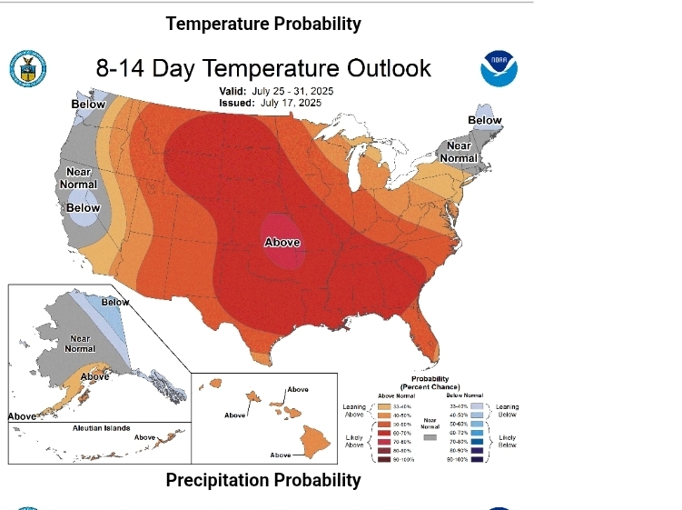
- Today
-

2025-2026 ENSO
so_whats_happening replied to 40/70 Benchmark's topic in Weather Forecasting and Discussion
Subsurface for June and the first half of July..thumb.gif.4dd911703b260808903981836c1348c6.gif)
-
2025-2026 ENSO
so_whats_happening replied to 40/70 Benchmark's topic in Weather Forecasting and Discussion
Impressive a 606 in 2005 -

July 2025 Obs/Disco ... possible historic month for heat
w1pf replied to Typhoon Tip's topic in New England
Nice.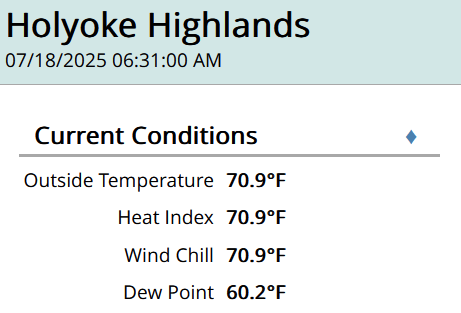
-
If you want to look at long-term trends, Its important to separate station changes from weather changes. The city to airport transition in Detroit introduces a bias. The City airport is warmer than Metro, particularly for low temperatures. I've looked at Ann Arbor, Pontiac, Detroit City and Detroit metro. Pontiac and Ann Arbor both go back 100+ years. I see a warming of winter extreme temps at each site. Less at the city airport and most at Pontiac. Note that I showed data for daytime highs, because low temperatures are more likely to be impacted by heat island and other local site radiating conditions. One final comment. Decade data can be misleading because 2010-2019 gives a different answer than 2015-24. In the case of extreme winter weather the difference in 10-year snapshots is amplified by large natural variability. We are still going to get cold shots and no question the 2010s had an unusual concentration. Don't see evidence though that Detroit is getting the same degree of extreme cold that it did in the past.
-
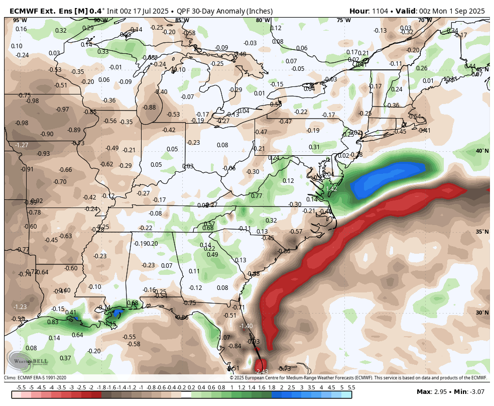
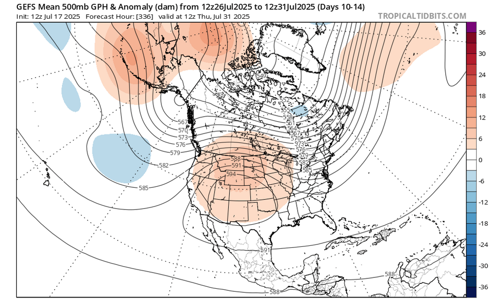
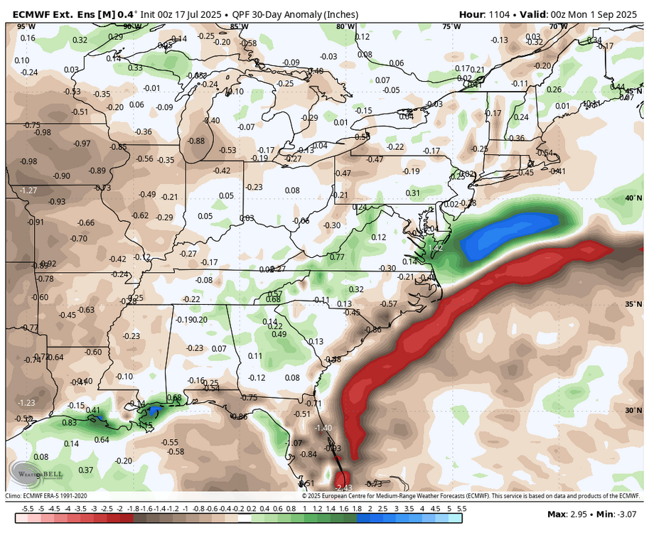
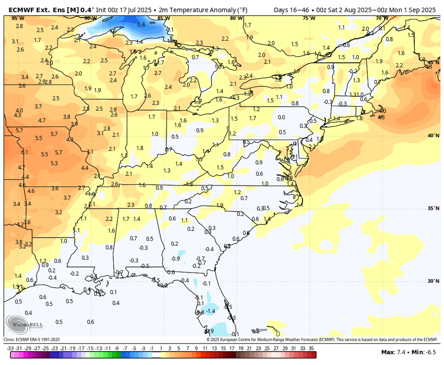
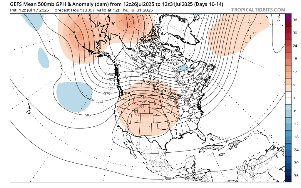
Latest WB weeklies now go through August....extreme heat stays out west....
-
2025-2026 ENSO
so_whats_happening replied to 40/70 Benchmark's topic in Weather Forecasting and Discussion
They have definitely seen this in the midwest since 2011. Specifically Iowa and Minnesota have seen this and parts of Illinois over the years.
.png.502020b6edf3235659073a50b386e183.png)


.gif.8d4e2f8f373a815a253ee8cd7f9dc5a4.gif)