All Activity
- Past hour
-
Acatt loves the gfs
-
sounds a lot like June 1994 (although June 1994 heat was more widespread). Why did the heat abruptly end after June in 1994, Tony? I saw that Philly still had a very high number of 90 degree days that entire summer (although it didn't match 1993 which was historic everywhere), but why did the heat end early in NYC that year? I noticed that the records for today are from June 1994 (including a 101 at EWR?)
-
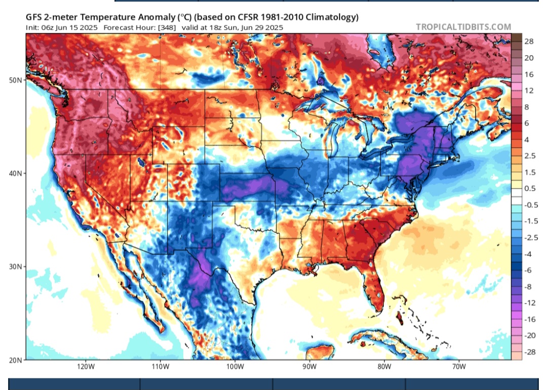
Not sure why anybody looks at the gfs anymore.
-
I think LGA numbers are inflated because of dense road traffic in that area (I see it all the time with my car thermometer, leaving Manhattan and entering Queens via the mid town tunnel the temperature rises at least 5 degrees and falls back down again when I get onto the Grand Central.) I've always thought both highs and lows in that area are highly suspect. Maybe NYC is not properly sited either, in which case, an average of all 4 sites (EWR,NYC,LGA,JFK) should be used for both the highs and the lows. BTW this extreme traffic issue in northern Queens started after the 90s.
-
Was much more pronounced west of the city during that June heatwave where EWR and C/N NJ hit 90 (9 of 10 days) with maxes of 100, 97, 98,99, 98 so the folks west of there felt it.
-
You should preface that with Central park in NYC - LGA hit 100 in June in 2021 (6/30).
-
0.3 overnight and just 0.65 for the month, with today and tomorrow looking like the typical dreary drizzlefest with not much rain. After the wet May, maybe we're back to the <1 inch monthly totals that March and April had
-
When does summer start?
-
Flakes by the end of the month?

-
0.45” overnight
-
We Walt
-
Slow climb to the inferno this week. 90 for some places on Thursday. The real stuff kicks in after the weekend
-
1991: The second largest volcanic eruption of the 20th Century began as Mt. Pinatubo injected 15 to 30 million tons of sulfur dioxide 100,000 feet into the atmosphere. 343 people were killed in the Philippines as a result of the eruptions, and 200,000 were left homeless. Material from the explosion would spread around the globe, leading to climate changes worldwide as the sun's energy was blocked out and global temperatures cooled by as much as one degree Fahrenheit. 1992 was globally one of the coldest since the 1970s. This was a real tragedy, when we learn to control volcanoes and earthquakes we won't have such tragedies anymore.
-
Yeah good luck. They’ll try to say COC because it dropped to 87 as beads of sweat slowly ooze down from balls to bum crack.
-
This heat is just the appetizer, Walt. I expect it will dry out the soil and give all of us 95+ temperatures. I expect the real deal to happen in early July when we will all have multiple days over 100!
-
Does this indicate big heat for July too? In my experience we don't hit 100 in June (it has never happened here before and in NYC it hasn't happened since 1966), but I predict if we get to at least 95 in June we will definitely have multiple days over 100 in July.
-
Nice! I actually got "volunteered" to work today. Full timers don't work weekends unless they choose to, but since today is Father's Day, at least a couple of part timers didn't want to come out. If we're short on manpower, we have to cover it, and today was my assigned day.
-
last year *heat* didn't even register with me lol. It has to be hot everywhere otherwise it's not real heat.
-
ACATT will try and poke and post holes in that today.
-
Maybe it's because the western basins are warming faster..... it's happening in the Atlantic too. There is a see saw effect, if one side warms faster the other side has to go in the opposite direction?
-
Thu night into Fri morning
- Today
-
The summer of 1980 was an epic furnace, start to finish. Let’s hope not….
-
Astonishingly we had similar progression with the signal for the same period, last year which lead to the strong heat in NJ 6/20 - 6/27. The center of the ridge will be key as you detail if those east of NJ continue with the recent tendency for onshore or if its full blast westrlry
-
Forcing does appear to be quite strong with the deepening trough, so at this point it does seem plausible for there to be at the very least some strong thunderstorms around Thursday afternoon and evening. This is supported quite well by the machine learning guidance by UCAR/NCAR which has a targeted area of severe weather potential over the Mid-Atlantic and Northeast. Will continue to monitor for trends in the guidance but regardless, the general idea that a front will bring showers and thunderstorms to the area is consistent with the guidance. Improving weather should return by Friday and into next weekend as high pressure returns.
-
Euro is also in alignment