All Activity
- Past hour
-
For now sure. But once the STJ goes of the scale it’s going to get very wet. December and January likely over 5” each. .
-

2026-2027 Record-breaking El Nino
Typhoon Tip replied to Stormchaserchuck1's topic in Weather Forecasting and Discussion
Yeah...maybe. Don't know. Parsing out the momentum like that over years - that's harder ( at least for me ) to balance sheet that because circulation modes get seasonally mutilated by winter and summer for one. But, the 23 spring planetary temperature explosion phenomenon is super climatological in nature and really appears to have taken place mutually exclusive of the ENSO cycling. We need to bear in mind that the sea system and the atmospheric system, en masse, burst .5 C upward in all dimensions, all at once. That in and of itself is still not very satisfyingly explained ...though there are some compelling ideas. sure. But anyway, that took place prior to the end of of a cool ENSO, and a couple months before the onset of an ... interim warm phase that frankly I feel was some sort of "absorption event" to try and eat that heat and didn't reflect a truer Nino atmospheric circulation mode outside of the immediate tropics...maybe lower subtropical bands... but that's farmer John's supposition. Anyway, detonating an entire planet like that doesn't lend to stable predictions. -
We could use the break since the last month and change have been rather wet. Nearly 5" at my station for the last 31 days. At least I can keep the sprinklers on a bit longer with the projected AN temps into November. I wonder what the chances are that NYC doesn't see a freeze until December at this point.
-
 We’ll see if we can get a PV split to shake out in our favor. Like I have been saying the Arctic isn’t totally cooked right now, so cold air will be lurking. That’s why I’m excited for this winter, I think it has some real surprises in store. Plus from a pure weather perspective, the STJ amped storms will be interesting in their own right even if they are mainly rain. .
-
happy fall..yall. 37 noted on digi car thermo w/ spotty frost noted on travel to work this am. 35 was lowest seen in my normal cold spot. decent amount of roofs and shaded lawns had frost on shaded north and west facing. Some mesquitos likely did not make it, but id say not hard enough to wipe em out. Just enjoying fall, while we likely have to wait a while for decent winter weather. All good.
-
Low of 30 according to nearest PWS. Very frosty again.
-
Low of 34 again, with some patchy frost
-

2026-2027 Record-breaking El Nino
40/70 Benchmark replied to Stormchaserchuck1's topic in Weather Forecasting and Discussion
Yea, right.......but even considering that logic, you would think that there would be some additional give relative to 2023, whereas that former regime even more deeply entrenched....I mean, El Nino is stronger...PDO is less negative and the warm pool is further east. This is why I believe there is more wiggle room for a window later in the season. -
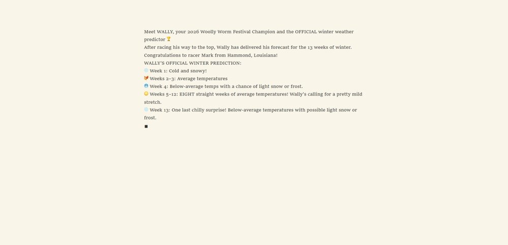
I was at the Woolly Worm Festival this weekend and here it is-----
-
2026-2027 Fall/Winter Mountain Thread
Met1985 replied to BlueRidgeFolklore's topic in Southeastern States
29 degrees again here this morning with a heavy frost. -
2026-2027 Record-breaking El Nino
Typhoon Tip replied to Stormchaserchuck1's topic in Weather Forecasting and Discussion
Yup ... and I realize we've been over this aspect before. But these signals don't turn an entire planetary system on it's head that quickly. There's momentum stored in the other mode and takes time to move away. It's sort of analogous to a seasonal change ... ex, we don't observe Aug 15 --> Nov 15 on a straight 45 deg downward angular trajectory. It goes back and forth while accumulating the lower height state over that span... in theory. We can always count on a complete systemic rollback to July 15th on Xmas Eve! So, as we go from a cool-->warm(vice versa) ENSO state, the atmosphere will tend to a kind of 'non-Markovian' echo of the form mode. It complicates matters further these days when/since previous modes became increasingly more disrupted ..heh. However, in this case since the -PDO is significantly correlated to the -ENSO, and the PDO is really a reflection of the longer term SS wind stressing in the quasi-coupling of the air-sea environment out there (therefore, atmospheric mode-), there's decent enough confidence that we actually had an NINA hemisphere last winter. -
2 frosty mornings in a row, 32 Sunday morning and 30 this morning.
-
2026-2027 Record-breaking El Nino
40/70 Benchmark replied to Stormchaserchuck1's topic in Weather Forecasting and Discussion
Maybe latter January...I think we all agree that the seasonal mean will be tough sledding, no pun intended lol -

2026-2027 Record-breaking El Nino
MJO812 replied to Stormchaserchuck1's topic in Weather Forecasting and Discussion
Relying on February to produce is a bad sign for the winter. Hopefully we get lucky with an event this winter -
2026-2027 Record-breaking El Nino
40/70 Benchmark replied to Stormchaserchuck1's topic in Weather Forecasting and Discussion
I was just speaking of the image Chris posted. -
2026-2027 Record-breaking El Nino
40/70 Benchmark replied to Stormchaserchuck1's topic in Weather Forecasting and Discussion
Every intense EL Nino has had it...only that was fairly neutral was 1982.....but I think that +WPO is part of the reason why February maybe somewhat better. -
-
36.5 at mi casa. It was clearly closer to freezing outside of my neighborhood though because I saw frost as soon as I got a half a mile from the water. Barring any super strong front, it’ll prob be mid-Nov before my station sees freezing or lower. Quite a bit of smoke on the water though (hits guitar solo), so the step down process is underway.
-
We can hope
-

2026-2027 Record-breaking El Nino
LakePaste25 replied to Stormchaserchuck1's topic in Weather Forecasting and Discussion
Like I said, we need to ditch the +WPO. Probably as we approach mid November would my guess, once the Siberian High can flex east of the Himalayas while the MJO exits the Indian Ocean. Would force a more equatorward pac jet and an organized Aleutian/GOA Low. -

2026-2027 Record-breaking El Nino
mitchnick replied to Stormchaserchuck1's topic in Weather Forecasting and Discussion
So you are disregarding last night's Eps that pulls the west coast trough wnw off the coast toward the GOA as well as the last 4 weeklies runs (at least) that has the Aleutian low and trough developing in the SE? -
Min 29.0° Atmospherically fake. Vegetatively real.
-
Second sub-freezing morning in a row. Low of 30 with heavy frost.
-
2026-2027 Record-breaking El Nino
LakePaste25 replied to Stormchaserchuck1's topic in Weather Forecasting and Discussion
Need to get rid of that +WPO. Always bad news for Ninos, let alone any ENSO. -
2026-2027 Record-breaking El Nino
40/70 Benchmark replied to Stormchaserchuck1's topic in Weather Forecasting and Discussion
Has to be mainly attributed to daily mins...just guessing....although certainly the past couple have been cold.