All Activity
- Past hour
-
probably cirrus... but we track. there are a few ways that can change though
-

September 2025 OBS-Discussion centered NYC subforum
Stormlover74 replied to wdrag's topic in New York City Metro
Getting a downpour now -
My bias is not part of this conversation. I know you’re ready to start one of your 5th grade personal attacks
-

September 2025 OBS-Discussion centered NYC subforum
SACRUS replied to wdrag's topic in New York City Metro
Highs TEB: 82 * EWR: 81 New Brnswck: 81 ACY: 80 PHL: 80 ISP: 80 NYC: 80 BLM: 79 TTN: 79 JFK: 78 LGA: 78 -
Reminds me of the "Video Professor"
-
I've cracked double digits!!!!!! 0.10"$$$$$$$$$$$ Sent from my SM-X210 using Tapatalk
-

2025-2026 ENSO
donsutherland1 replied to 40/70 Benchmark's topic in Weather Forecasting and Discussion
Convection during neutral ENSO events is more evenly spread out; during La Niña it's farther west (often but not always in the vicinity of the Maritime Continent); during El Niño, it's located in the cental/eastern Pacific. Depending on how the atmosphere and ocean couple, these differences matter. MJO phases in the Maritime Continent often favor warmth in eastern North America. ENSO, of course, is but one variable that shapes seasonal outcomes. Other variables can outweigh it. -

-
What is the ceiling of potential impacts in Templeton, MA? Irene level flooding?
-

September 2025 OBS-Discussion centered NYC subforum
Sundog replied to wdrag's topic in New York City Metro
They have lowered altitude significantly unfortunately. For me it's takeoffs from LGA. I can clearly read the writing on the planes with a quick phone pic. Sometimes I say to my wife I think they're going to land on the boulevard nearby they're so damned loud and low. -
September 2025 OBS-Discussion centered NYC subforum
Sundog replied to wdrag's topic in New York City Metro
Maybe KDIX can get its act together and clean up the radar. -

September 2025 OBS-Discussion centered NYC subforum
uofmiami replied to wdrag's topic in New York City Metro
I get non-stop planes overheard on approach into JFK runway 22 now at 1800 to 2000 over my house & my parent's in Muttontown. Can always tell a 747 by the sound alone. While planes flew over Great Neck from LGA when I was kid & lived for 30 or so years, they were always at a higher altitude so not as noisy in my experience. -
How can the ENSO cool and La niña composites have completely opposing temperature anomalies in the eastern US? The temperature of the tropics can't have been that different in these two scenarios, why would its effect suddenly reverse?
- Yesterday
-

September 2025 OBS-Discussion centered NYC subforum
ForestHillWx replied to wdrag's topic in New York City Metro
Decent shower rolled through, now a line is forming north of 78. -
94L looks quicker on some models now
-
Euro AI

-
yeah buddy keep telling santa what he needs that’s gonna get you the toy train this year
-

Invest 94L—40% 2 day and 80% seven day odds of development
MJO812 replied to WxWatcher007's topic in Tropical Headquarters
Euro AI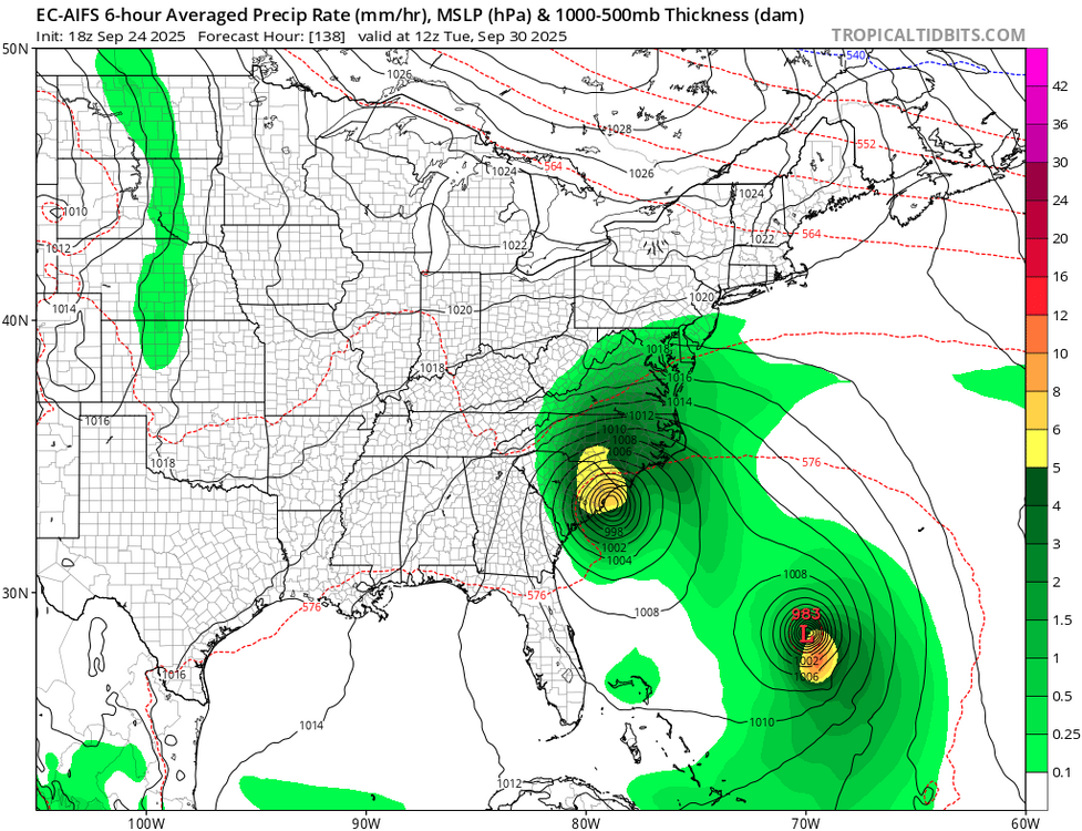

-

Invest 94L—40% 2 day and 80% seven day odds of development
GaWx replied to WxWatcher007's topic in Tropical Headquarters
Tropical Weather Outlook NWS National Hurricane Center Miami FL 800 PM EDT Wed Sep 24 2025 For the North Atlantic...Caribbean Sea and the Gulf of America: Eastern Caribbean Sea (AL94): Showers and thunderstorms have become better organized since yesterday in association with a tropical wave centered near Puerto Rico. This wave is expected to move west-northwestward around 10 to 15 mph, spreading heavy rainfall and gusty winds across Puerto Rico and the Dominican Republic through early tomorrow. The system is then expected to slow down and turn northwestward when it reaches the southwestern Atlantic. A tropical depression is likely to form when the disturbance is in the vicinity of the Bahamas late this week. Interests in Puerto Rico, the Dominican Republic, the Turks and Caicos Islands, and the Bahamas should monitor the progress of this system. * Formation chance through 48 hours...medium...40 percent. * Formation chance through 7 days...high...80 percent. Public Advisories on Humberto are issued under WMO header WTNT33 KNHC and under AWIPS header MIATCPAT3. Forecast/Advisories on Humberto are issued under WMO header WTNT23 KNHC and under AWIPS header MIATCMAT3. Forecaster Blake -
EPS
-
September 2025 OBS-Discussion centered NYC subforum
SACRUS replied to wdrag's topic in New York City Metro
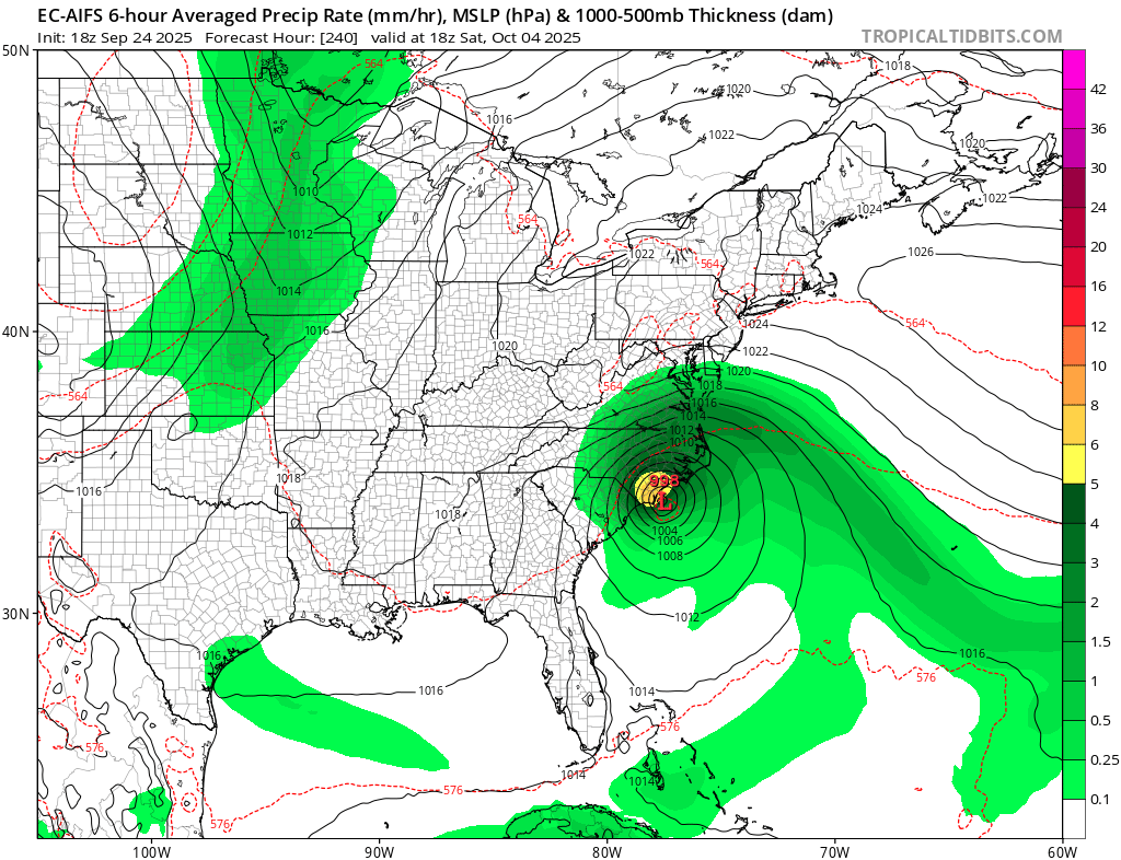
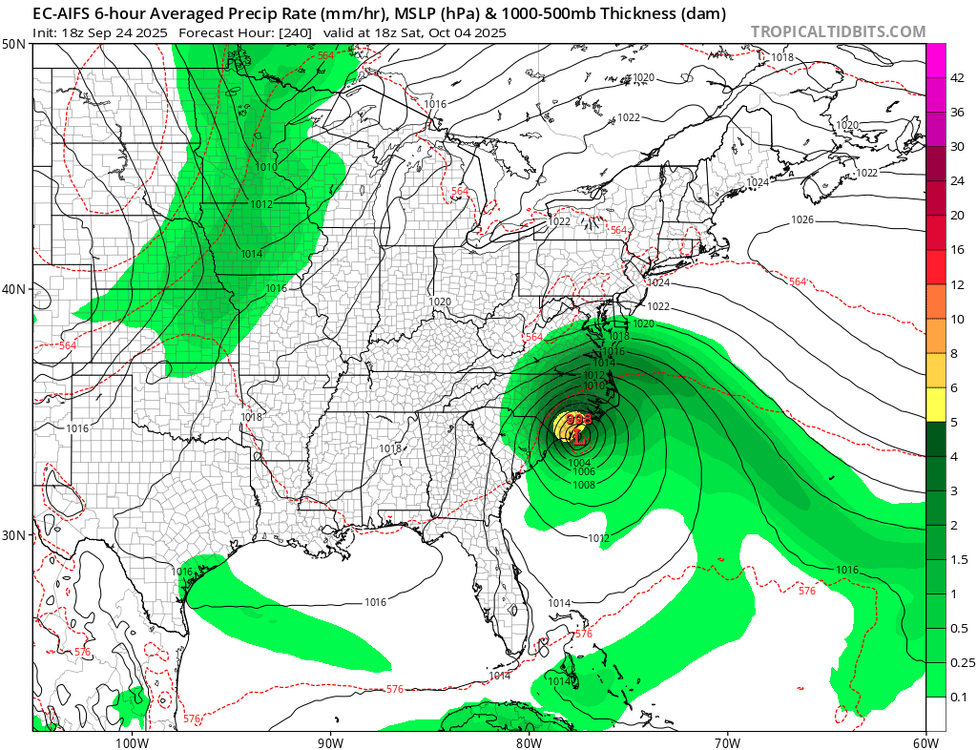
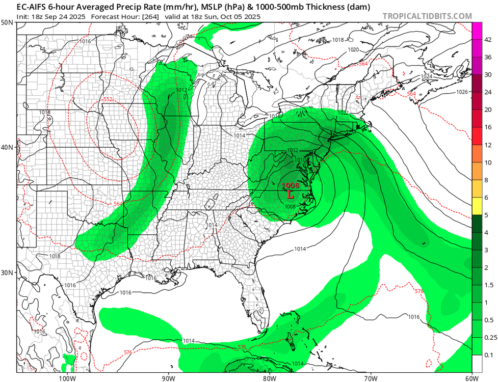
18z - 00z - 12z - 18z euro with twin systems (developing a low near the Bahamas as Humberto heads west in the Atlantic off the southeast coast by Tue - Fri next week. 12z brings one back into the Mid Atlantic and the region by D 11. -
EPS following the op
-
This link will take you to where you scroll through dew points on various models. You can even adjust to the model that fits your thoughts, unless there isn’t one https://www.tropicaltidbits.com/analysis/models/?model=gfs®ion=neus&pkg=Td2m&runtime=2025092418&fh=6
-
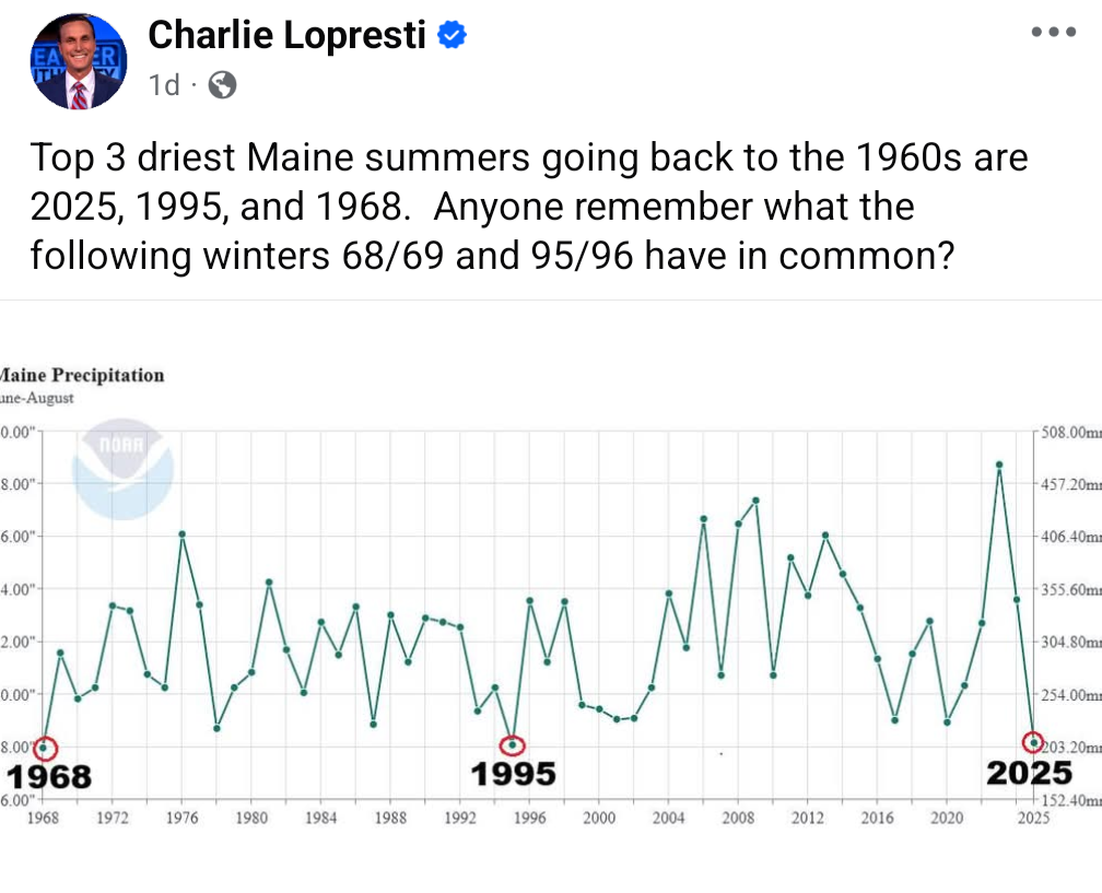
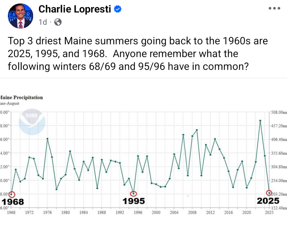
Correlation does not equal causation, but in this case I hope it does! We need a good snowmobile registration year or we're going to start having some serious trail funding issues. I had to beg and plead for the state to give us 50% of what we need for a major reroute due to an out of stater buying land and shutting off a snowmobile trail used since 1972...
-
Gloomy at BDL, 67/64 OVC011. Looking forward to Friday's torch.


.thumb.jpeg.406ecda2eec9e267302c22b9f128fe3c.jpeg)