All Activity
- Past hour
-
From the NH stroke play championship last week. Multiple pin locations like the one shown and the yardage on my watch (493) was a par 4…


-
Yes, folks here are always too quick to cancel, but we gotta be honest—you would need a lot to happen to make this a bona fide EC threat that this point. You will see this on ensembles—which are the better option for analysis—but I’m using the op because it’s easier to see. The troughing signal to our west is obviously important to having any chance but it’s poorly timed, poorly positioned, and too slow to cut off. That can change at this range but that’s a secondary issue. The first and most fundamental issue is that the weakness in Atlantic ridging is happening way way way too early. It’s basically turning near Bermuda. That weakness isn’t out in weenie range. And while to Pope’s point it can change (and I think the GFS is too early with the weakness), whenever you’re asking a lot of the steering conditions in tropical, it usually doesn’t work out. So while it’s not over technically, the odds of a U.S. hit are looking increasingly small imo. Last thing I’ll say though is that even with the super ensemble the longer range members tend to be underdispursive. If that troughing in the eastern US is real I’d watch in Atlantic Canada. They’ve actually done exceptionally well with these kind of setups in recent years.
-
Pete's already moved into stick steason.
-
Close approach, yeah that's not out of the question. zzzz
-

Mid to long range discussion- 2025
WinstonSalemArlington replied to wncsnow's topic in Southeastern States
Pushing Erin out to sea? -
It is! From 1915 or something. Restored to original design in 2008.
-
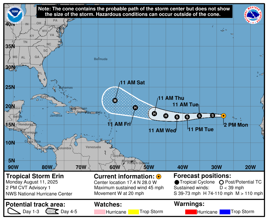
000 WTNT45 KBAR 111447 TCDBAR5 Tropical Storm Erin Discussion Number 1 Barry Central Pub Forecast Centre AL052025 200 PM CVT Mon Aug 11 2025 Right lads & lasses, she’s on. The lass Erin’s finally laced up her boots after mucking about over them Cabo Verde Islands, and now she’s off down the wing at 17 knots; proper pace, none of this sideways passing nonsense. Got the Dvorak ratings in from the boffins, said she’s at 40 knots now which is about a Force 8 on the Blackpool Prom scale. She’s heading west like a winger on the counterattack, could cut slightly south if she fancies a nutmeg on the Azores defence. Midfield ridge still keeping her onside, but give it a few days and she might drift poleward for the big shot. Model spread at the end’s as wide as the gap in England’s back four in the 2010 World Cup. Intensity forecast: tricky one. Small lass, could bulk up quick or trip over her own laces. Pitch conditions are fair; light shear, but only 26-27°C SSTs so not exactly a warm pint. Dry air lurking like the away fans. Expect her to slowly work up to a respectable Cat 1 by midweek, then maybe start putting the proper goals in later on when she finds warmer waters. Models say she could be a major by full-time. CAM ON ERIN. FORECAST POSITIONS AND MAX WINDS INIT 11/1500Z 17.4N 28.0W 40 KT 45 MPH 12H 12/0000Z 17.5N 31.2W 45 KT 50 MPH 24H 12/1200Z 17.4N 35.1W 50 KT 60 MPH 36H 13/0000Z 17.1N 38.7W 55 KT 65 MPH 48H 13/1200Z 17.1N 41.7W 60 KT 70 MPH 60H 14/0000Z 17.4N 45.0W 70 KT 80 MPH 72H 14/1200Z 18.0N 48.4W 80 KT 90 MPH 96H 15/1200Z 19.6N 54.0W 90 KT 105 MPH 120H 16/1200Z 21.5N 60.0W 100 KT 115 MPH $$ Forecaster Barry
-
Will Erin score any goals? BULLETIN Tropical Storm Erin Advisory Number 1 NWS National Hurricane Center Miami FL AL052025 200 PM CVT Mon Aug 11 2025 ...TROPICAL STORM ERIN FORMS JUST WEST OF THE CABO VERDE ISLANDS... SUMMARY OF 200 PM CVT...1500 UTC...INFORMATION ---------------------------------------------- LOCATION...17.4N 28.0W ABOUT 280 MI...455 KM WNW OF THE CABO VERDE ISLANDS ABOUT 2305 MI...3710 KM E OF THE NORTHERN LEEWARD ISLANDS MAXIMUM SUSTAINED WINDS...45 MPH...75 KM/H PRESENT MOVEMENT...W OR 275 DEGREES AT 20 MPH...31 KM/H MINIMUM CENTRAL PRESSURE...1004 MB...29.65 INCHES
-

Mountain West Discussion
mayjawintastawm replied to mayjawintastawm's topic in Central/Western States
COCORAHS agrees with most of the Denver Metro receiving a trace or less over the last 3 days. We got a trace. Incredible how the forecasts have busted low so much, and so consistently, the last several weeks within the 470 circle. -
Be careful what you believe.
-
11-15 days...just in time for my return from Udanda. Beautiful.
-

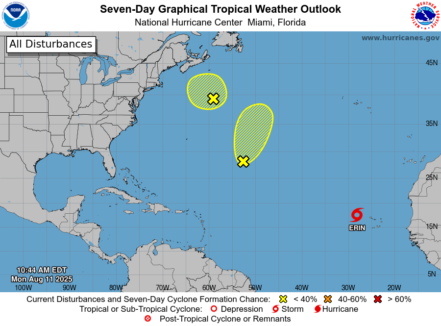
2025 Atlantic Hurricane Season
BarryStantonGBP replied to BarryStantonGBP's topic in Tropical Headquarters
-

Central PA Summer 2025
TheClimateChanger replied to Voyager's topic in Upstate New York/Pennsylvania
Like I said, the record lows were already shared. I shared a record high that happened yesterday. Why would I post about record lows that happened over a week ago and were already shared? -
Tropical Storm ERINAs of 12:00 UTC Aug 11, 2025: Location: 17.3°N 27.3°WMaximum Winds: 40 kt Gusts: N/AMinimum Central Pressure: 1004 mbEnvironmental Pressure: N/ARadius of Circulation: N/ARadius of Maximum wind: N/A
-
Maybe somewhere between that and verifying a modeled day 7 snowstorm during Winter
-
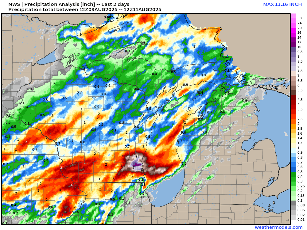
wow, yeah, close to a foot of rain in MKE the past couple of days, and absolutely nothing across the lake...
-
@CoastalWxis going to hunt you for bringing that up lol He becomes angry at the mere mention of it.
-
0.4 over actually. I was doing it with the 3-day weather history. Must have picked up a dew point at 61
-
CAM ON ERIN BAM BAM BAM Special Message from NHC Mon, 11 Aug 2025 14:10:30 +0000 NHC will initiate advisories on Tropical Storm Erin, located in the Eastern Tropical Atlantic, just west of the Cabo Verde Islands, at 1100 AM EDT (1500 UTC). SCORE SOME FAKKIN GOALS LASS
-
Getting crushed with heavy rain this morning. Over an inch already and lots more coming.
-
Not to nitpick but BOS was 84/64 yesterday which is exactly normal. Felt pretty hot once west of the city however at least my real feel.
-
1.5F below the record high daily mean, which was 83.5F set on June 19, 2024. Prior to that date, the record had been 82.5F.
-
It was 96 on June 19, 2020 & June 19, 2024. I missed the other 96F from 2020 because it only lists the most recent on the "calendar day summary." Interestingly, that same day (June 19) has matched the all-time record at CAR twice in the 2020s.
-
June 19, 2020 rather than last year. I chose that May day to add 6" of fiberglass insulation to the attic of our tiny (18x20) 2-story. Finished by 11 AM but it was already near 90 outside, 120+ in the workspace. Next day CAR had 95/69; that 82° mean is only 0.5° below their all time hottest.
-
The haves and the have nots. When will this heat spill south and east out of northern New England and Upstate New York? It's like an impenetrable wall.