All Activity
- Past hour
-
The more north this comes the south the boundary gets for the next storms.
-
Damn, hook me up.
-
Because of one model that’s rarely right? Dude.. come on.
-

February 2026 OBS & Discussion
WeatherGeek2025 replied to Stormlover74's topic in New York City Metro
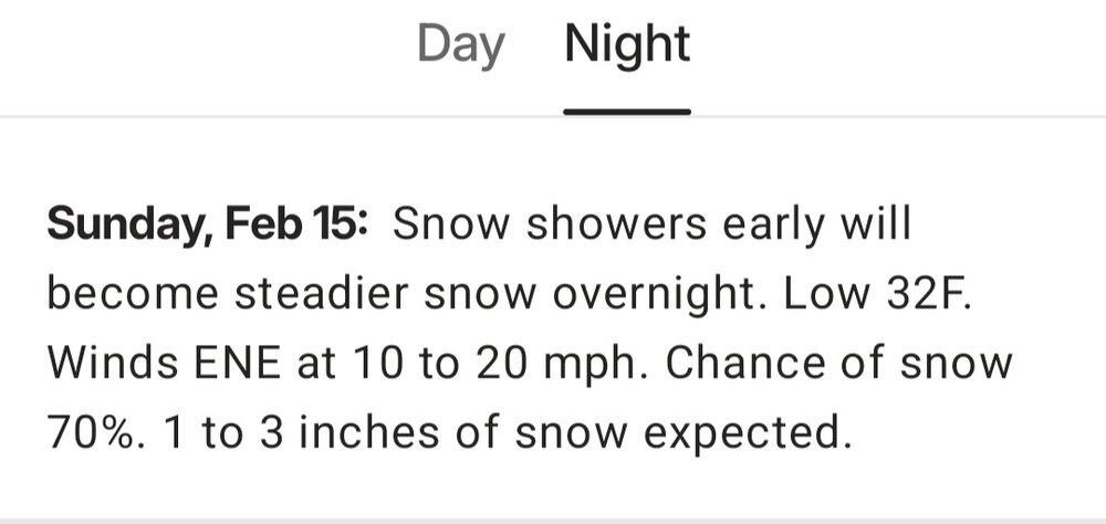
@Rjaycan we get the thread back after tonight's 0z runs? Wow great weekend coming nice little coating possible tonight and more Sunday night and I can stay up and track all weekend! Let's go guys -

E PA/NJ/DE Winter 2025-26 Obs/Discussion
Newman replied to LVblizzard's topic in Philadelphia Region
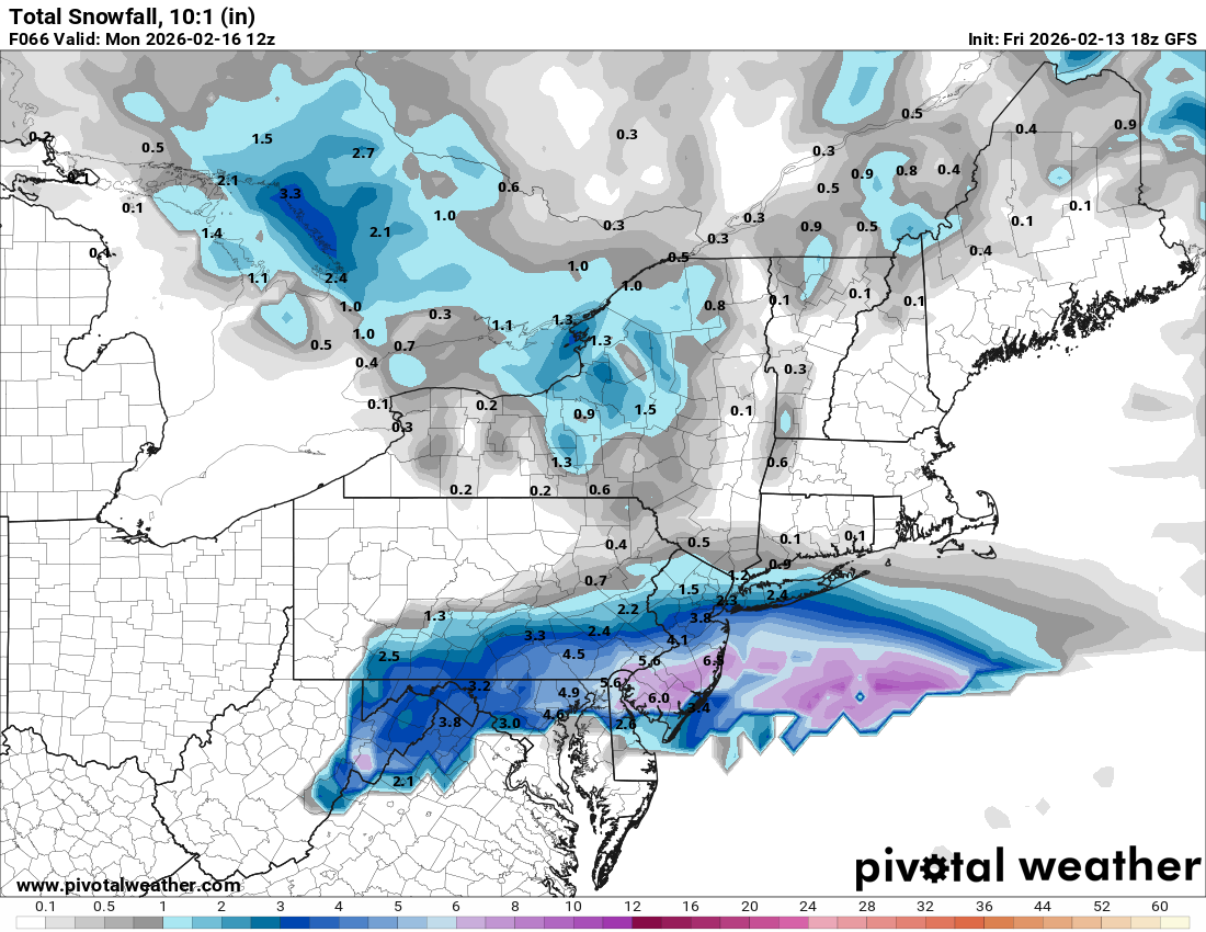
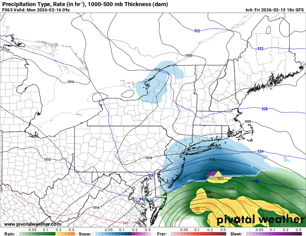
GFS looks solid for SE PA. Like I said, keep ticking this slowly each run up until Sunday night and it's gonna be a legit storm -
Anybody who's braving the pre-storm traffic...have they started salting the roads yet in prep?
-
I find this acceptable
-

February 2026 OBS & Discussion
donsutherland1 replied to Stormlover74's topic in New York City Metro
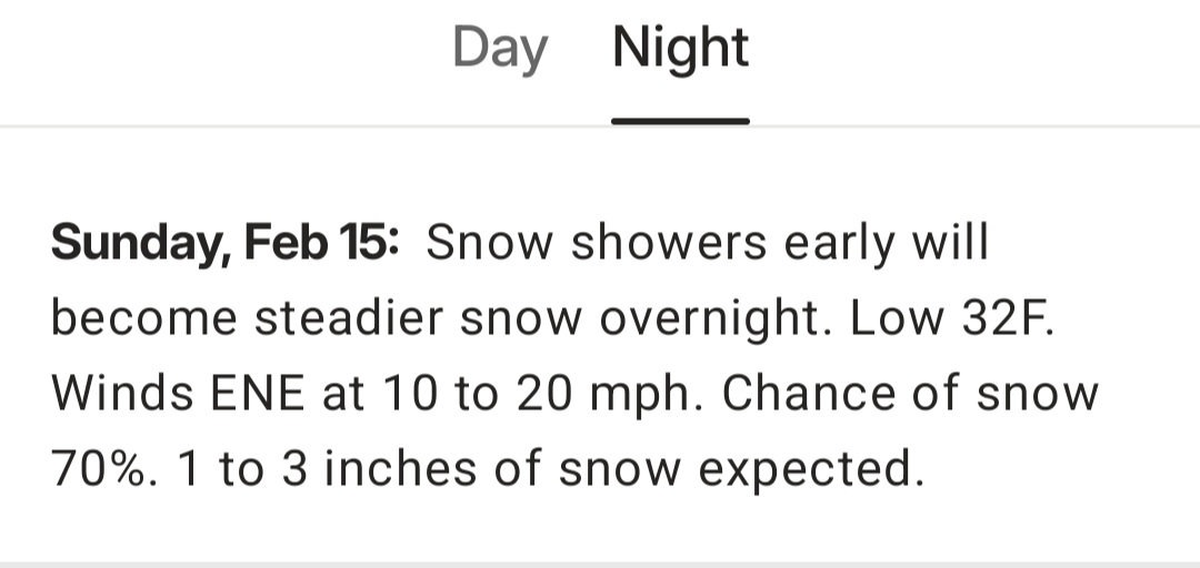
Tomorrow and Sunday will see temperatures reach the upper 30s and lower 40s. A flurry or burst of light snow is possible in some areas tomorrow. A few areas could see a dusting. Some precipitation could arrive on Sunday or Monday. Areas with the highest probability of seeing precipitation will be south of New York City. A minor accumulation of snow is possible. It will likely become even milder with highs in the lower to middle 40s for a time next week. The ENSO Region 1+2 anomaly was +0.3°C and the Region 3.4 anomaly was -0.5°C for the week centered around February 4. For the past six weeks, the ENSO Region 1+2 anomaly has averaged -0.25°C and the ENSO Region 3.4 anomaly has averaged -0.52°C. La Niña conditions will likely continue into at least late winter. The SOI was +7.93 yesterday. The preliminary Arctic Oscillation (AO) was -0.519 today. Based on sensitivity analysis applied to the latest guidance, there is an implied near 94% probability that New York City will have a cooler than normal February (1991-2020 normal). February will likely finish with a mean temperature near 31.5° (4.4° below normal). Supplemental Information: The projected mean would be 3.8° below the 1981-2010 normal monthly value. Overall, Winter 2025-2026 is on track for a seasonal mean temperature of 31.9°. That would be the lowest winter mean temperature since Winter 2014-2015 when the mean temperature was 31.7°. Winter 2025-2026 would only become the fourth winter of the 21st century with a mean temperature of 32.0° or below. -
So it begins
-

E PA/NJ/DE Winter 2025-26 Obs/Discussion
MJO812 replied to LVblizzard's topic in Philadelphia Region
Gfs with a nice shift -
The Sierra Nevada got hammered on Christmas. 18 days later, we went into the tank w/ temps. I think we get colder a bit sooner than that, but check this out... Mono County- Including the cities of Lee Vining, Bridgeport, Mammoth Lakes, and Coleville 1106 AM PST Fri Feb 13 2026 ...WINTER STORM WATCH REMAINS IN EFFECT FROM SUNDAY EVENING THROUGH WEDNESDAY EVENING... * WHAT...Heavy snow. Snow accumulations between 15 to 30 inches west of Highway 395, with 2 to 4 feet in the high Sierra. This includes locations such as Conway Summit, Lee Vining, June Lake, Mammoth Lakes, and Toms Place. 8 to 18 inches near and east of Highway 395, such as Bridgeport, Walker, Bodie, and Benton. Lesser amounts of 2 to 4 inches for the Chalfant Valley. Winds gusting 35 to 45 mph, with up to 65 mph for wind prone locations along US-395. Sierra ridge gusts over 100 mph.
-
Gfs on board
-

February 2026 OBS & Discussion
CPcantmeasuresnow replied to Stormlover74's topic in New York City Metro
Really just eight hours. The game started at 6 PM and the snow came in like a wall into the city between 2 and 3 AM. -
February 2026 OBS & Discussion
WeatherGeek2025 replied to Stormlover74's topic in New York City Metro
can we get the thread back John?
-

January 25-26 Winter Storm Potential
Chadzachadam replied to Ralph Wiggum's topic in Philadelphia Region
I had snow on the ground for the whole month of February 2021. I think it was exactly 28 days though so should surpass it soon -
It's kind of an interesting scenario because just about all models are trending towards a better phase if you cycle the past 4 runs or so. Even the RGEM and NAM which don't look great at the surface. QPF increases dramatically among the individual ensemble members based on degree of phasing. But as is right now the model consensus is still miss or fringe.
-
Boomer Esiason was QB that game, I remember warm ups showing the temp and winds, sucks to play in that weather, worse than the Green Bay ice bowl.
-
.thumb.png.b3e148c660566ee84f8ec4a78f8c3f7d.png)
.thumb.png.15f4a970a64619e828547b631d52c7ef.png)
-
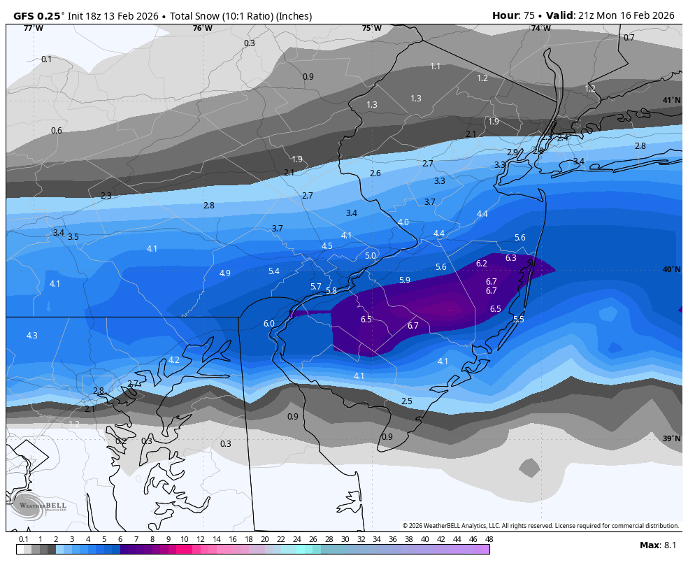
Gfs ticking north
-
Courtesy of 33andrain

-
10:1 higher than Kuchera thanks to warmish temps.
-
Pretty big increase on gfs

-
-
-
Wow gfs Welcome back


.png.2308b756a7314b7d47f670f6d721fd15.png)
.png.ea3f108c97405a9a1e8838140f86fee0.png)