All Activity
- Past hour
-
Will the negative interference from the torch guy prove good juju for some... time will tell

-

January 2026 Medium/Long Range Discussion
MDScienceTeacher replied to snowfan's topic in Mid Atlantic
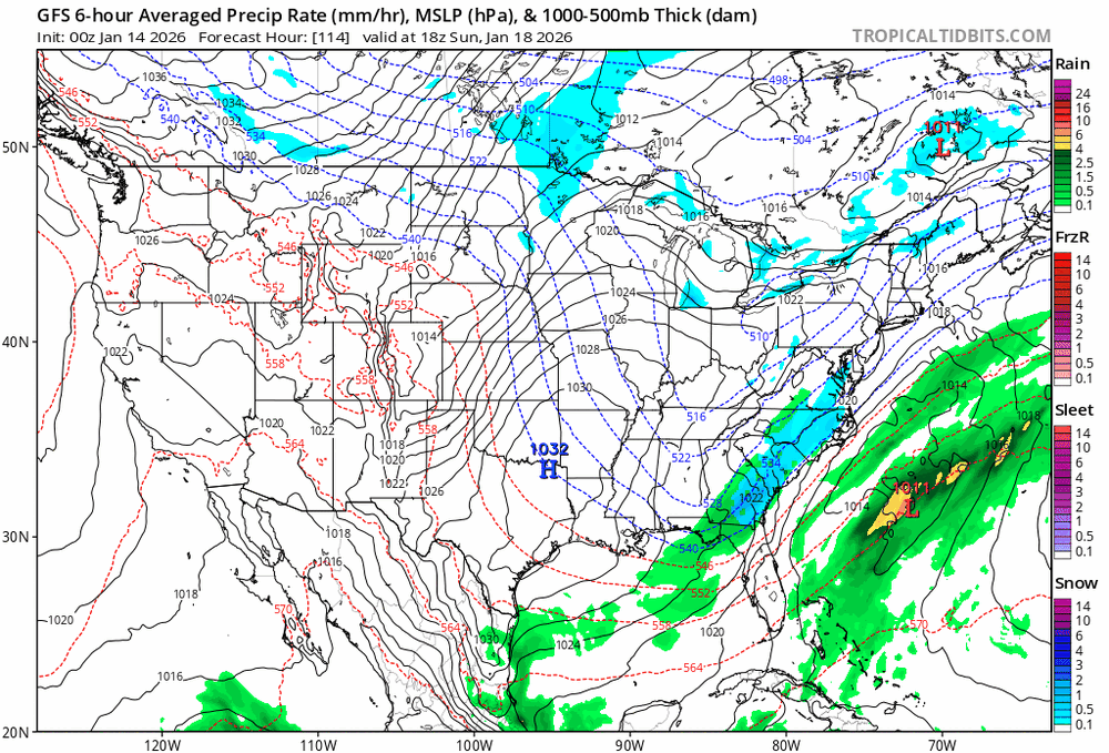
The euro has a nice clipper at hour 348 -

Mid-Long Range Discussion 2026
gamecockinupstateSC replied to BooneWX's topic in Southeastern States
-
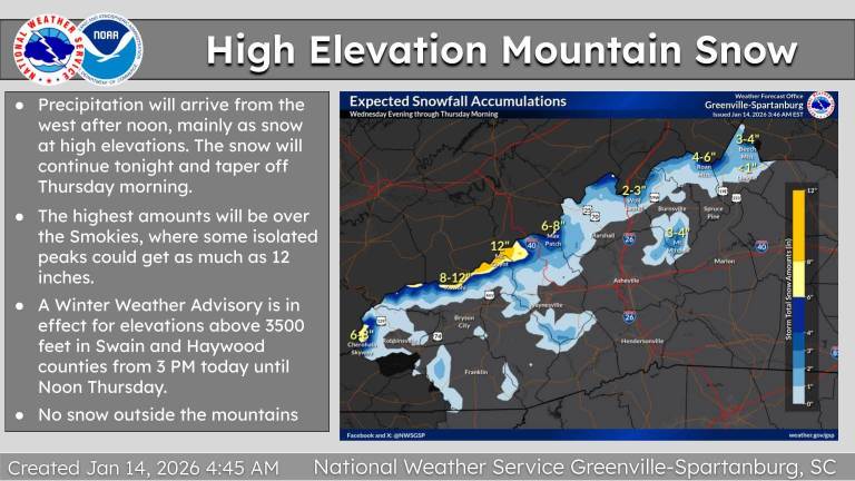
From GSP this morning. Sent from my SM-G998U using Tapatalk
-

Central PA Winter 25/26 Discussion and Obs
mahantango#1 replied to MAG5035's topic in Upstate New York/Pennsylvania
Flash freeze? Hazardous Weather Outlook National Weather Service State College PA 439 AM EST Wed Jan 14 2026 PAZ010>012-017>019-025>028-034>036-041-045-046-049>053-056>059- 063>066-150945- Elk-Cameron-Northern Clinton-Clearfield-Northern Centre- Southern Centre-Blair-Huntingdon-Mifflin-Juniata-Bedford-Fulton- Franklin-Northern Lycoming-Southern Clinton-Southern Lycoming-Union- Snyder-Montour-Northumberland-Columbia-Perry-Dauphin-Schuylkill- Lebanon-Cumberland-Adams-York-Lancaster- 439 AM EST Wed Jan 14 2026 This Hazardous Weather Outlook is for central Pennsylvania. .DAY ONE...Today and tonight. Rain mixing with or changing to snow along with plummeting temperatures below freezing could result in slippery conditions late tonight into Thursday morning. .DAYS TWO THROUGH SEVEN...Thursday through Tuesday. The probability for widespread hazardous weather is low. .SPOTTER INFORMATION STATEMENT... Spotters are encouraged to report significant hazardous weather. -

Winter 2025-26 Medium/Long Range Discussion
A-L-E-K replied to michsnowfreak's topic in Lakes/Ohio Valley
And it's gone.gif classic -

January 2026 regional war/obs/disco thread
dendrite replied to Baroclinic Zone's topic in New England
I like that 1045 high with yore Carolina CAD. -

January 2026 regional war/obs/disco thread
CoastalWx replied to Baroclinic Zone's topic in New England
Yeah still could go poof but it’s been inching west -

January 2026 regional war/obs/disco thread
ineedsnow replied to Baroclinic Zone's topic in New England
We can hope.. we need this! -
January 2026 regional war/obs/disco thread
CoastalWx replied to Baroclinic Zone's topic in New England
Still a nice overrunning signal in the extended -
GFS brings back the storm signal in that 9-10 day range we’ve seen
-

January 2026 regional war/obs/disco thread
UnitedWx replied to Baroclinic Zone's topic in New England
It's definitely inched closer the last several runs. Can the trend continue?... -
January 2026 regional war/obs/disco thread
ineedsnow replied to Baroclinic Zone's topic in New England
Ya that's been the one to watch.. might get a bit in the interior Saturday.. some models also starting to show that.. -
January 2026 regional war/obs/disco thread
CoastalWx replied to Baroclinic Zone's topic in New England
Euro AI a few inches too. -
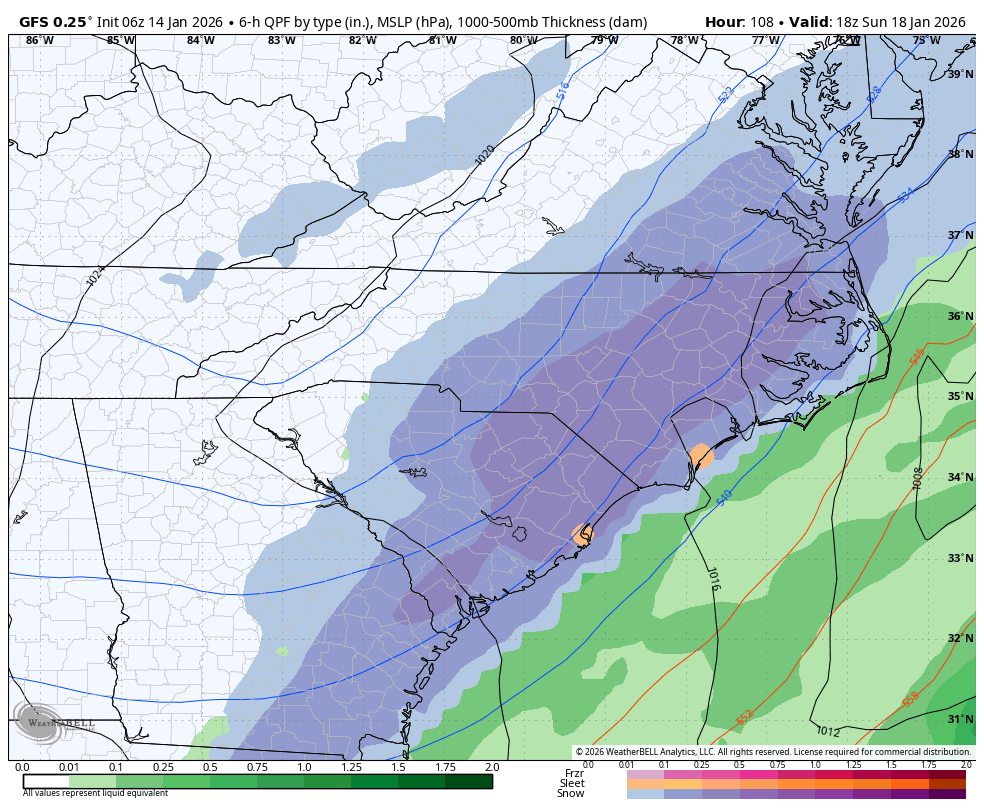
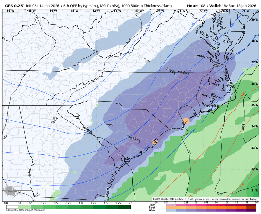
GFS is 2-4” from triad through triangle then 4-8” in the coastal plain with no mixing pretty much anywhere aka a pretty sweet storm as shown
-
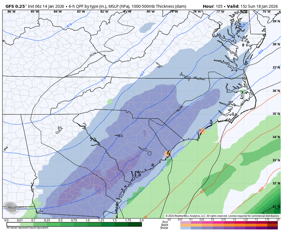
GFS came nw again at 06z compared to 00z
-
January 2026 regional war/obs/disco thread
CoastalWx replied to Baroclinic Zone's topic in New England
6z gfs is several inches for MLK and 00z euro grazes. Definitely one to watch. -
UKMET is aggressive. .
-
6z GFS closer..
-
6z GFS is a beaut for central/eastern NC
-

Central PA Winter 25/26 Discussion and Obs
Voyager replied to MAG5035's topic in Upstate New York/Pennsylvania
Sometimes I'll jokingly post about it, but not to complain about it. - Today
-

January 2026 regional war/obs/disco thread
Modfan2 replied to Baroclinic Zone's topic in New England
41F and balmy for this time of year -

January 2026 regional war/obs/disco thread
WeatherGeek2025 replied to Baroclinic Zone's topic in New England
euro bad and icon bad too now. this storm might not happen at all -

January 2026 regional war/obs/disco thread
40/70 Benchmark replied to Baroclinic Zone's topic in New England
Guessing no, since posts went "poof" faster than the long range PD II. -

2025-2026 Fall/Winter Mountain Thread
ncjoaquin replied to Buckethead's topic in Southeastern States
Good Lord Met1985!!! Do you have some spare rooms for people to hang out??? 2026 NCZ051-052-141430- /O.NEW.KGSP.WW.Y.0001.260114T2000Z-260115T1700Z/ Swain-Haywood- 123 AM EST Wed Jan 14 2026 ...WINTER WEATHER ADVISORY IN EFFECT FROM 3 PM THIS AFTERNOON TO NOON EST THURSDAY ABOVE 3500 FEET... * WHAT...Snow expected above 3500 feet. Total snow accumulations up to 11 inches. Winds gusting as high as 45 mph. * WHERE...Elevations above 3500 feet in Haywood and Swain Counties. * WHEN...From 3 PM this afternoon to noon EST Thursday. * IMPACTS...The heavy snow will make many roads impassable and may produce widespread power outages due to the weight of the snow on tree limbs and power lines. The hazardous conditions could impact the Wednesday evening and Thursday morning commutes. Gusty winds could bring down tree branches.