All Activity
- Past hour
-
Maybe just my own false perception but it seems August has been particularly bad for severe the last several years? Growing up in the 70’s/80’s it didn’t seem like that? I vividly remember some spectacular events in those days
-

2025-2026 ENSO
40/70 Benchmark replied to 40/70 Benchmark's topic in Weather Forecasting and Discussion
This doesn't mean you should book 70" of snowfall at LGA.....but it is what it is. The PNA should be just south of neutral in the DM mean. -
2025-2026 ENSO
40/70 Benchmark replied to 40/70 Benchmark's topic in Weather Forecasting and Discussion
-
I think I see why. Looking at the upper left of each plot, the jet is further north in the new vs old. So instead of buckling southward into western US, it goes over the top of NW Canada promoting a ridge there. Big changes downstream.
-
2025-2026 ENSO
40/70 Benchmark replied to 40/70 Benchmark's topic in Weather Forecasting and Discussion
And I agree, as it was strongly positive last year, but I don't think it will be strongly negative this season. -

Tropical Storm Erin - NOW AT 45 KTS @ 18Z!
WxWatcher007 replied to BarryStantonGBP's topic in Tropical Headquarters
I’d go even lower, but I guess I’d just preach caution until recon has had a chance to sample Erin and the surrounding environment before feeling too confident in the exact details of the recurve. -
Its a dewey cox kinda day out there
-

E PA/NJ/DE Summer 2025 Obs/Discussion
MGorse replied to Hurricane Agnes's topic in Philadelphia Region
Picked up 0.41 inches of rain yesterday. Just a tad muggy out this morning! -
 79 / 73 clearing working down N - W / NW- SE
 -
Looking at @frd's 6-10 day outlook, which shows most of the Mountaineer State 2 to 5F above recent climatological normals (with the exception of a small portion of the Eastern panhandle), I think the temperatures should be sufficiently high to push the West Virginia statewide mean high enough to at least tie, if not break, the record for hottest summer. That gets us to August 24 - the question then becomes whether that can hold for the final week. This is a record that was first set 125 years ago (albeit tied in 2010)! Stay tuned!
-
Don’t worry the trough will be there whenever tropical reaches the SW Atlantic.
-

BAY OF CAMPECHE 98L NOW UP TO 20/20
BarryStantonGBP replied to BarryStantonGBP's topic in Tropical Headquarters
why does this frog do this all the time? if 98L gets named it repeats the same pattern -
2025 Atlantic Hurricane Season
BarryStantonGBP replied to BarryStantonGBP's topic in Tropical Headquarters
probably gonna be a poundshop erin (dollar store for yous lot) -

BAY OF CAMPECHE 98L NOW UP TO 20/20
GaWx replied to BarryStantonGBP's topic in Tropical Headquarters
This is convectively active this morning. The SW Gulf often over-performs with regard to the models. -
The last two UKMET runs also have this followup to Erin.
-
I'm ready for fall
-
Update on summertime temperatures: Both Virginia and West Virginia saw their second hottest June-July period on record. Virginia had a gridded mean of 76.6F, second only to 2010's mean of 77.0F. At West Virginia, the two-month mean finished at 73.8F, second only to 1934. Incredibly since 1952, only one June-July came within 1F of that value (and only barely). The mean in 2010 was 72.9F, or 0.9F cooler than this year. August has started MUCH colder. My best estimate for the current mean is 71.5F in Virginia and 70.7F in West Virginia. Very rare for the two states to have such similar mean temperatures. West Virginia is usually decidedly colder on average. The Virginia value if it were to hold would match 1986 for 13th coldest August on record. West Virginia's implied mean is already in the warmer half of all Augusts. If these values were to hold, Virginia's summer mean would finish at 74.9F (13th hottest), while West Virginia's summer mean would finish at 72.8F (tied for 4th hottest). We can safely rule out a record hot summer for Virginia; however, a top 10 hottest summer is still very much possible. Currently, there is a 3-way tie for 10th place between 1952, 2002 & 2005. August would probably need to finish around 72.1F or higher for a top 10 summer. Now, the mean of 72.8F for West Virginia falls just 0.2F shy of the current record hot summer (1900 & 2010, both at 73.0F). To tie those years, we would need to see August finish around 71.3F. To break them, around 71.6F. To put that into perspective, 71.3F is the 1991-2020 mean, so West Virginia would only need to have a normal August (based on most recent climatology) to tie the record.
-
Mark, is that you????
-
2025 Atlantic Hurricane Season
BarryStantonGBP replied to BarryStantonGBP's topic in Tropical Headquarters
sod off -
 Received .36" in late afternoon T-Shower. I guess a small slice of pie is better than no slice at all.
 -
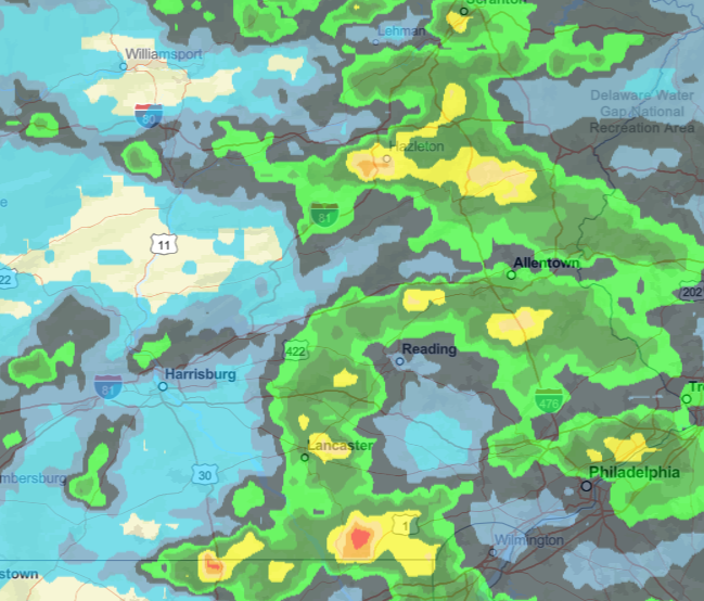
Most areas still good.
-
-
Tropical Storm Erin - NOW AT 45 KTS @ 18Z!
BarryStantonGBP replied to BarryStantonGBP's topic in Tropical Headquarters
dorians me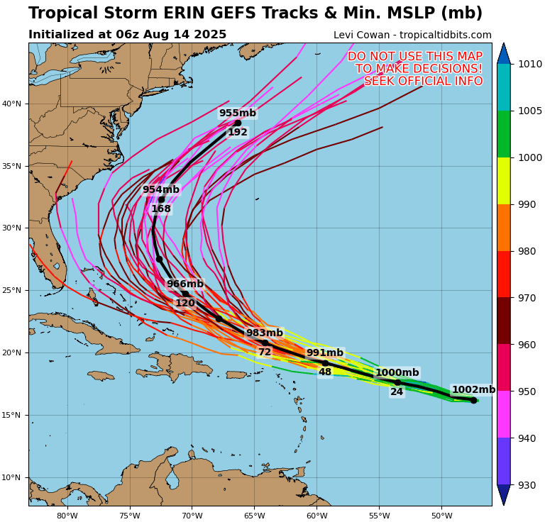
-
Decent rains across eastern sections.