All Activity
- Past hour
-
Yes the 12Z GFS and CMC are back to more reasonable temperatures as the week progresses. From Wednesday on upper 80s to lower 90s appears to be the rule with much cooler temperatures and showers/storms Wednesday night through Friday but let's remember how erratic the models are whereas the Euro has been consistently hot for most of the week and into next weekend. WX/PT
-
81 at noon
-
Just eyeballing the latest PAC SSTs, the PDO has gone severely negative again
-
I have to say that chat gpt impressed me mightily with how it handled, summarized, taught me, and predicted weather solely off of GOES satellite images. Although I don't fully comprehend all of the 20 different options available I think I have a pretty good understanding of about five. What they show how to read them and even how to forecast off of them somewhat. Amazingly, the 6 hour forecast it came up with based solely on the latest 12 image gif of each of the five was far superior to wunderground, AccuWeather, or the Mexican national weather service specifically for precipitation times, amounts, thunderstorm potential. I never would have thought about using GOES, if not for lack of radar, and I far underestimated all one could learn from them. Sent from my SM-G970U1 using Tapatalk
-
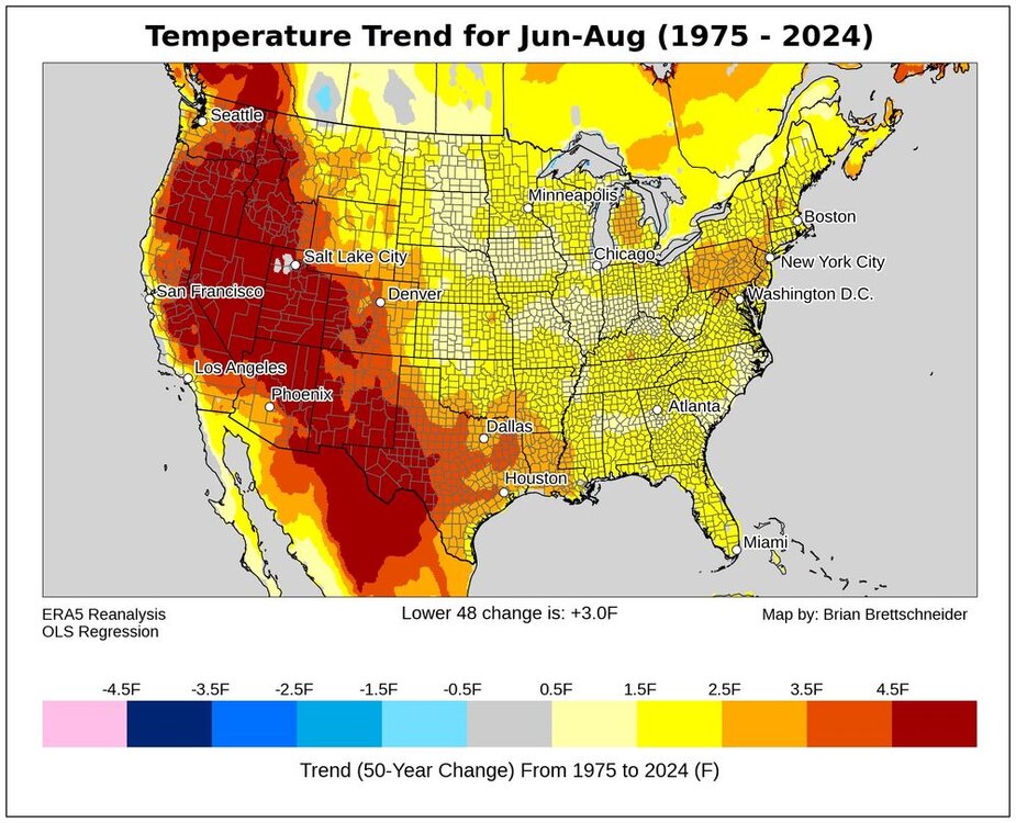
Yeah, areas west of the sea breeze front in interior SE NY, NJ and PA have seen the fastest summer warming in the East.
-
I couldn't stand that mass killing program that Bloomberg had going on during his administration, one of many things I couldn't stand about that billionaire reincarnation of Attila the Hun (his stature was just as small too.)
-
good to see some of our hotter summers on this list too, though the 2020s have exceeded them in Central PA. 9 2012 75.3 0 - 1944 75.3 0 10 2002 75.0 0 2010 76.4 0 - 1966 76.4 0 - 1949 76.4 0 4 1955 76.3 1
-

E PA/NJ/DE Summer 2025 Obs/Discussion
RedSky replied to Hurricane Agnes's topic in Philadelphia Region
They added tomorrow to the death torch. Love it. -
Yes, in the winter it's much more apparent, though summertime minima and increased rainfall and humidity are also strong indicators.
-
I knew it!!!! Sent from my SM-G970U1 using Tapatalk
-
wild, are those locations also getting an elevated number of 90 degree (hot) days? Typically in the Poconos we can count on heat during the day but it would always cool off at night so we didn't need air conditioning, we just opened our windows and the outside air would cool down my house at night. 2024 was different as it was hot during the day and at night.
-
No the bigger indication is how few 0-10 degree days we see. WX/PT
-
-
The really big extreme for warmth during the 2020s in PA has been Bradford and Reading. All the 2020s summers have landed in the top 10 warmest. With 2024 setting the record for warmest in both locations. So those locations are way too far inland to be influenced by the increased onshore flow here in recent summers. Time Series Summary for BRADFORD REGIONAL AIRPORT, PA Click column heading to sort ascending, click again to sort descending. 1 2024 68.2 0 2 2021 67.3 0 3 2022 67.0 0 - 2020 67.0 0 4 2016 66.5 0 5 2018 66.3 0 6 2012 66.1 1 7 2023 66.0 0 - 2005 66.0 0 - 1991 66.0 0 - 1975 66.0 0 8 1959 65.9 0 9 2011 65.8 0 - 1993 65.8 0 - 1987 65.8 0 10 2019 65.3 0 Time Series Summary for Reading Area, PA (ThreadEx) Click column heading to sort ascending, click again to sort descending. 1 2024 76.7 0 2 2020 76.6 0 3 2022 76.4 0 - 2010 76.4 0 - 1966 76.4 0 - 1949 76.4 0 4 1955 76.3 1 - 1943 76.3 0 5 2021 76.1 0 6 2016 76.0 0 7 2011 75.9 0 - 2005 75.9 0 - 1952 75.9 0 8 1959 75.6 0 - 1900 75.6 0 9 2012 75.3 0 - 1944 75.3 0 10 2002 75.0 0
-
-
 Little MCS moving into WPA/ SW WNY
 -
I still think Tuesday ends up being the highest temp of the year for most. Despite when the peak heat season is.
-
Rats, yes, geese, this was their habitat...
-
I'm always counting down to the Winter Solstice. Glad we start losing daylight after today. It will be hot AF for a few days, but we can deal.
-
Take a look at my avatar. It was me....
-
Obviously the timing of an MCS is in question but lets say we're looking at a window where something could develop along a residual outflow boundary...it's probably a very small window...like 10 AM - 1 PM. The extreme instability is going to be sick to see here, unfortunately, it means nothing without a lifting mechanism.
-
MTD June NOAA PDO is likely at ~~-2.3 and full June could easily be down to ~-2.5.
-
GGEM also has rain for the coast a lot during the winter lol
-
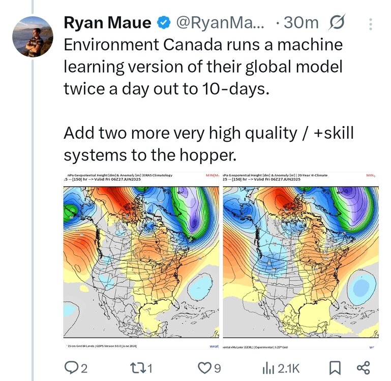
Tons of AI models around now. I had no idea the Canadian had them too