All Activity
- Past hour
-
Warmer AM, mid 30s but still some frost out there. spectacular day ahead.
-

2026-2027 Record-breaking El Nino
bluewave replied to Stormchaserchuck1's topic in Weather Forecasting and Discussion
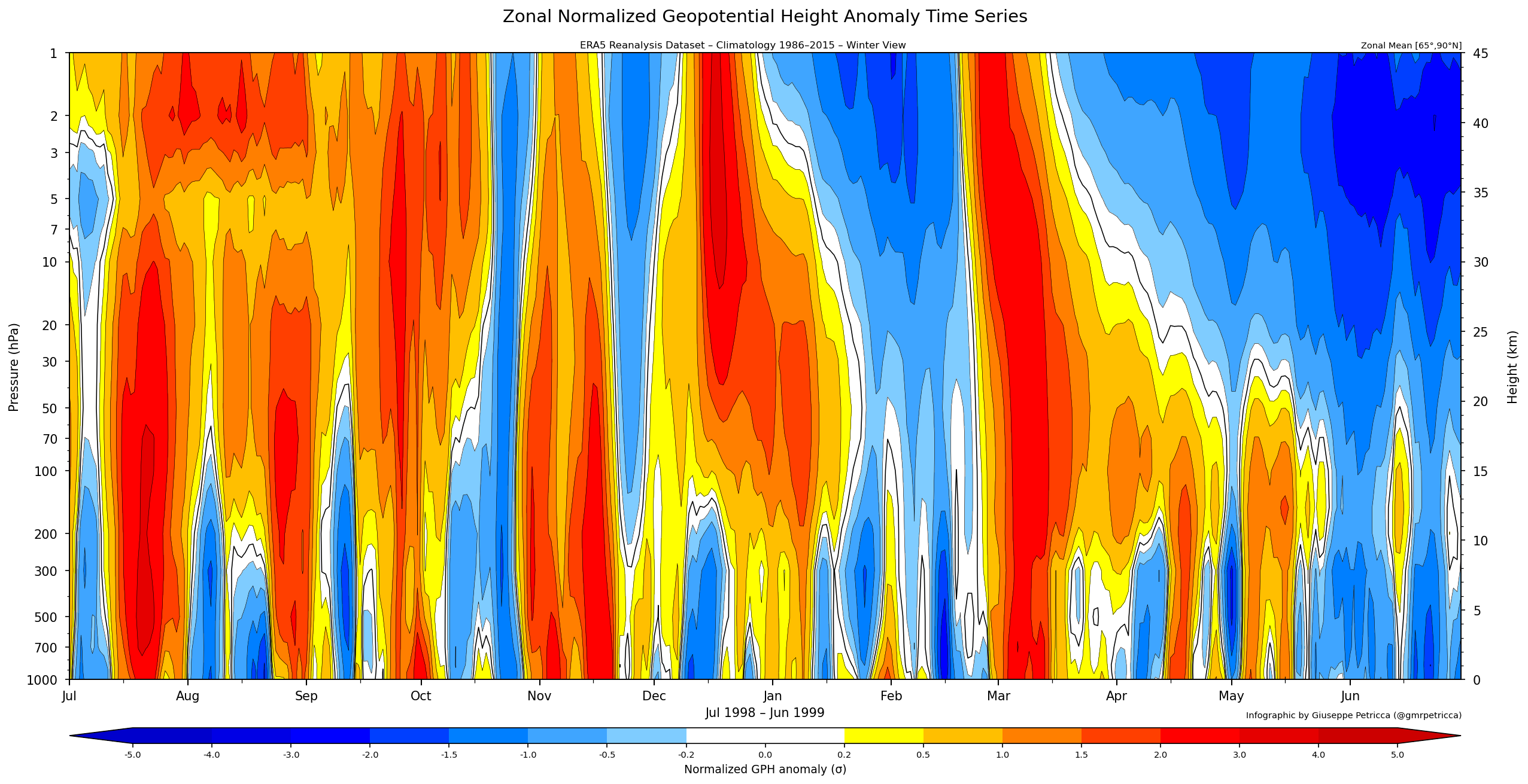
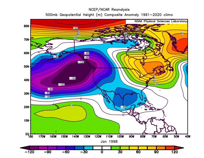
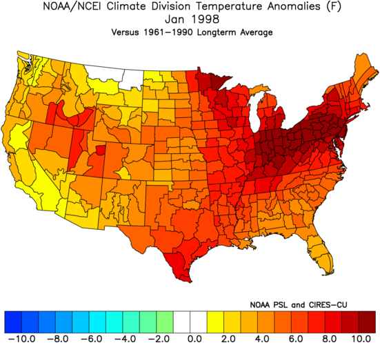
The lag interval for surface effects from minor and major stratospheric warming events can be quite variable. We had a minor warming event in late December 1997 and a strong Greenland blocking pattern emerged in January. But since the Pacific vortex was displaced so far to the east, it resulted in a very warm pattern over North America.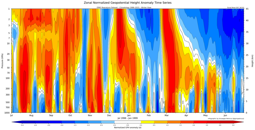
-
2 out rally’s are the best! Love when my softball team does it happy they won!
-
So here is a list I compiled long ago listed typical and atypical remarks found on SA airport reports before ASOS and METAR was adapted. REMARKS FOUND ON SA REPORTS CB W-N DRFTG W ACMAM OMTNS E-SE T N MOVG SE BD DSNT W T NW MOVG RPDLY SE PRJMP 21/0000/04 T MOVD S D2 TWR VSBY 1/2 HAIL SHAFT DSNT E FEW AC GREEN SKY NW T OVHD MVMT UNKN LARGE CB NE WATERSPOUT B22 1E MOVG LTL ARCUS ROLL CLD NW TB32E55 DSPTD DARK GREEN RWU N-NW OCNL LTGICCG N-NE LAST FQT LTGICCCCGCA ALQDS TCU BLDG RPDLY W-N CONTUS LTGCG VLY FOG FEW CU OVHD AND SW T OHVD-NE-S MOVG SLOLY SE VSBY LWR NW-NE LUNAR ECLIPSE SE FQT LTGICCCCW CORONA LTG W-NW SUN DOG OCNL DSNT LTG N MOON ECLIPSE VSBL E HLSTO 2 EARTH OVERSHADOWING MOON PRESFR FQT VIVID LTGCG N PRESRR GF IN LOW SPTS PRES UNSTDY APRNT FROPA MDT CU ALQDS OCNL SPKLS TCU E CLDS OBSCG MTN TPS NE-SE CB SW-W MOVG NE RW- OCNLY RW TORNADO OVHD MOVG NE RADAT ZERO| TORNADO MOVD N DRFTG SNW TORNADO B14E27 DSPTD BS3 CB PARENT CLD E MOVG E RVR10- FUNNEL CLOUD NE MOVG NE LSR08 SNOINCR 5/8/21 GRDL WNDSHFT S5 R05RVR50V60+ F4 WND LGT AND VRBL R1 ZRIPE39 SUN DMLY VSB SIL RADAT 93M041054096/2 SB1453E10 CHH RADAT DLAD THN SPOTS IOVC OUN RADAT MISG VSBY 1/2V1 RADAT N/A INTMT R- BA POOR PCPN VRY LGT PTCHY ICE ON RWY CIG RGD GREEN SKY IN LGT FLASHES NE FEW ST 5 HND VRY DRK E-S WND SHFTD GRDLY HLSTO PEA SIZE CI NE LRG BINOVC W HAZY ROTATING CLOUDS NW AC S T ALQDS STNRY BINOVC WALL CLOUD NW R- OCNL R BD OVR RWY PKWND 3462/20 SQUALL LINE NW DRK SW FQT DEADLY LTGICCCCG ALQDS PCPN 120 TOTAL PCPN 1.90 IN 36 MINS OCNL RW- DEBRI ALOFT AB17E21 ACFT MISHAP WND 26V34 T2 SET SML BINOVC DOWNBURST 2 W OF AIRPORT F DVLPG CB ANVIL N OVR LAKE RWU S-SW WR// BLK CLDS ALQDS RCRNR LN TCU W CIG 5V7 VSBY E 1 SEA BREAKING OVER BARRIER ACCAS S-SW TIDAL FLOODING HALF WEATHER STATION ISOLATED DUE TO TIDE WET SNW OBS SECURED BKN V SCT BRKS N SCT V BKN CLR W SFC VSBY 1 1/4 SC BANK NW FROPA HUR COND 1 SET WNDSHFT 40 ROTOR CLDS NW RF8 SCSL W LOWEST PRES 946 CCSL N-E OCNL SW- RDGS OBSCD W-N BD5 KOCTY FEW CUFRA F ALG RIVER T 6NE MOVG NE TIDE MINUS 001 UNCONFIRMED TORNADO 5W MVMT UNKN TIDE PLUS 005 CBMAM 5NW MOVG NE HAZE LYR ALQDS CB ALQDS NOSPL ACSL ALQDS STMG ALQDS BLDG CU W F DSPTG H1 F MOVG IN FM SW CC OVHD CLRG NW FQT LTGICCC IN CB NE-S CLR ALF MOON DMLY VSBL INTMT L- HIR CLDS VSBL SE COMMUNICATION FAILURE FEW STFRA SCUD DSNT ALQDS SWU ALQDS LLWS ALERT AURBO ARPT CLSD SNW RMVL T E LTL MVMT RVRNO ROTATION OBSERVED IN CLOUDS WND GUSTY VIRGA SE-S RAINBOW E TORNADO WENT UP INTO THE CLOUDS RW+ OCNLY RW- LRG CB WITH OVERSHOOTING TOP DSNT NE LSRPSRIR20P DRY WND DIRECTION EST DUE TO BIRD ON WND IRLSR17P WET VANE SANDED CONTRAILS OVC PTLY THN ST ALG RIVER SW-W THIN ICE PELLET LYR ON GRND LUNAR HALO LWR SCUD ALG HILLS E & W APRNT HVY RW S-SW CLDS TPG MTNS NE-SE POWER OUT AT STATION AT 12Z HVY FRST D ALF NMRS GUSTS 35 KTS PST HR LTG NOT OBSVD NO APRNT LTG CLD BNK NW TOT RN 767 F BLO SMT DARK S SKY DARK SW-NW DSPTG CU ALQDS T 2W STNRY PSBL CB DSNT SE HRZN DSNT LTG E AT 2028Z WT 28 SEAS 3-5 HALO AND PARHELION WALL CLOUD DVLPG SW OCTY AC FLOCCUS W-NW LK TEMP 66 TWO WELL DEFINED SC BANDS DSNT NW-NE AND DSNT SW-SE
- Today
-
 https://zenithindusrx.shop/# buy generic medicines online india
-
Looks like the rain chances disappeared for Sunday in my area. 3 weeks now without a drop.
-
2026-2027 Record-breaking El Nino
EasternLI replied to Stormchaserchuck1's topic in Weather Forecasting and Discussion
00Z EPS now has all members, 100% with reversals. GEFS still sitting around 70% AI ENS climbing after not being interested, close to 80% now, but I don't know how well that does with events like this either. -
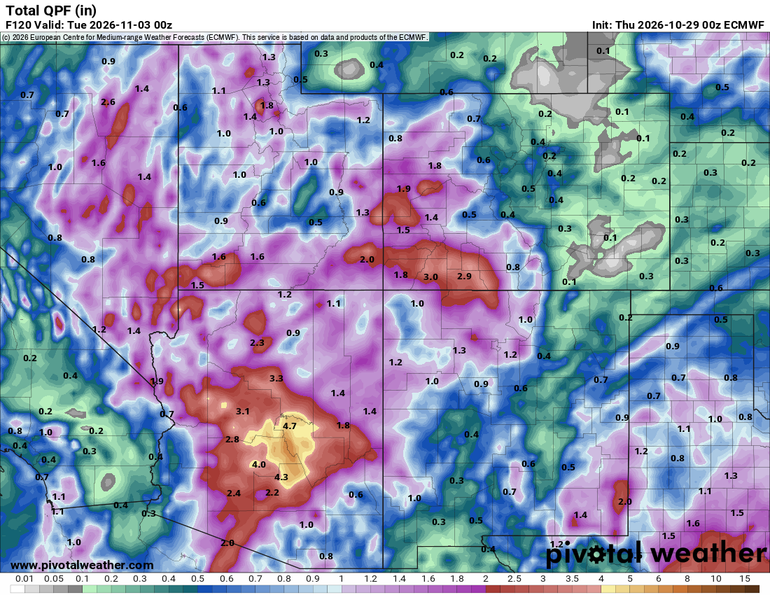
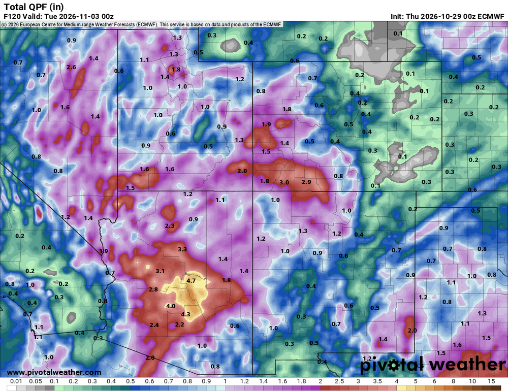
Me neither. It's beautiful, and I'm loving it! On the flip side, the crazy southwest desert weather continues as well. While this might be somewhat overdone (the ECMWF) every global model shows at least 2" of rain for the Phoenix metro area between now and next Monday night.
-
canada pharmacy world and canadian pharmacy 365 canada online pharmacy https://www.aiko.ed.jp/blog/mt4i.cgi?id=7&mode=redirect&ref_eid=3197&url=http://canpointerx.shop reputable canadian pharmacy and http://lenhong.fr/user/khqqzpchwc/ canadian pharmacy website [url=https://clients1.google.co.ls/url?q=https://canpointerx.shop]canada rx pharmacy[/url] certified canadian pharmacy and [url=https://lifnest.site/user/nvqjyywobonvqjyywobo/?um_action=edit]canadian pharmacy website[/url] canadian pharmacy official site
-
certified canadian pharmacy: CanPointe - canadian pharmacy compare
-
buy medications from india [url=http://zenithindusrx.com/#]ZenithIndusRx[/url] buying medicine online in india
-
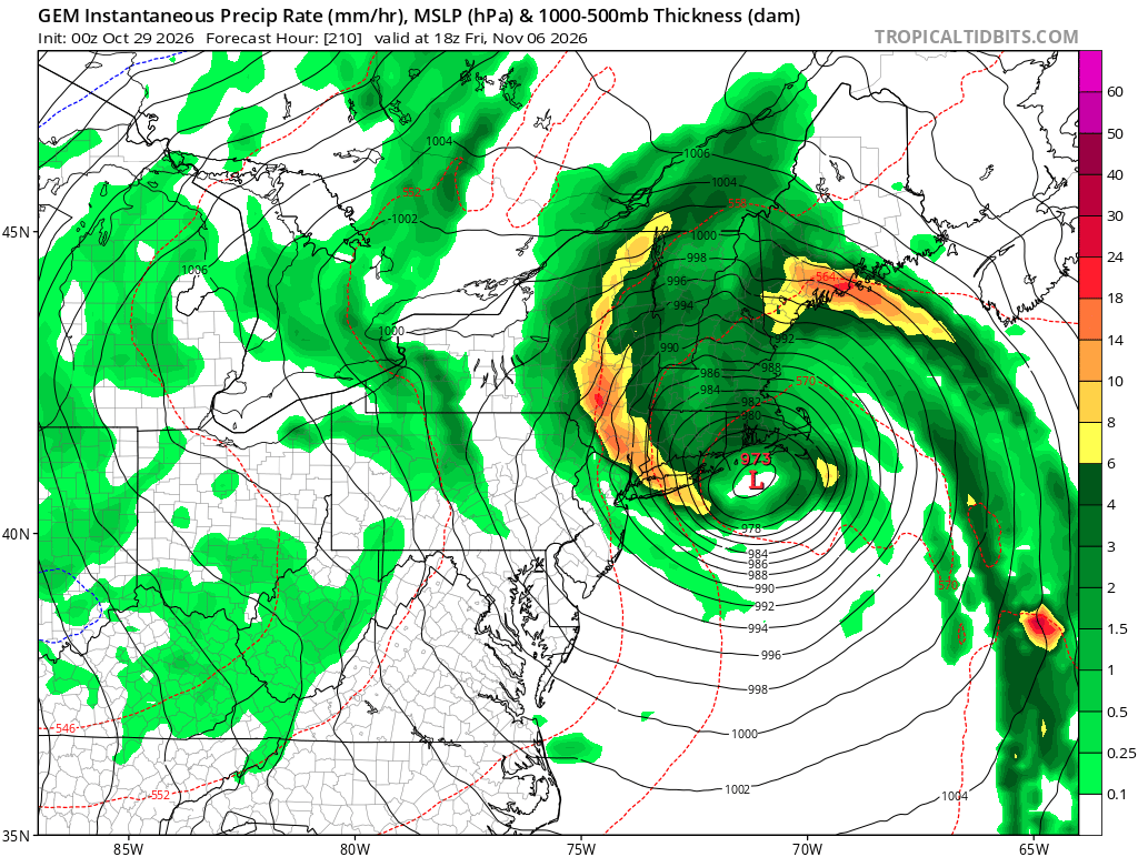
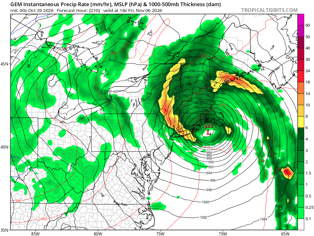
0Z EPS has a storm signal in about 8 days
-
That would be fun.. to bad its the CMC 9 days out
-
mexico prescriptions: FronteraCareDirect - mexican online pharmacy wegovy
-
Normal for BOS is around 11/10. I think I went below freezing 10/18.
-
https://fronteracaredirect.shop/# best online pharmacies in mexico
-
That’s actually not far above climo. I think the normal high for BOS mid November is low 50s. It’s still mid 40s in the opening days of December. Know thou climate.
-
-
prescription drugs from india and indian pharmacy store buy pharmacy online http://maps.google.mv/url?sa=t&url=https://zenithindusrx.shop online drugstore and https://kamayegaindia.com/user/ccvfqpvrea/?um_action=edit tablets delivery [url=http://images.google.la/url?q=https://zenithindusrx.shop]india online pharmacy[/url] online medicine purchase in india or [url=https://www.trendyxxx.com/user/golsajgtgv/videos]order antibiotics from india[/url] buy meds online
-

2026-2027 Record-breaking El Nino
GaWx replied to Stormchaserchuck1's topic in Weather Forecasting and Discussion
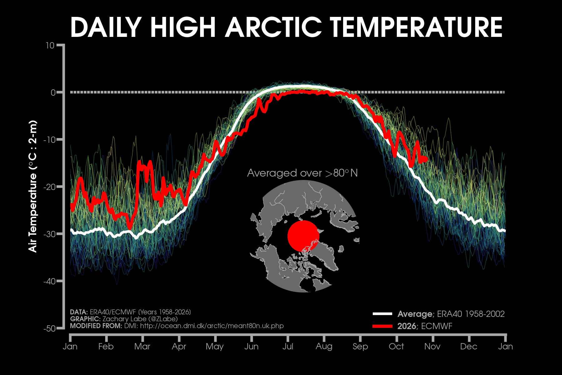
The Arctic N of 80N 2m anomalies have been back to their typical autumn warmer than 1958-2002 averages after a short dip to just BN at the end of Sept: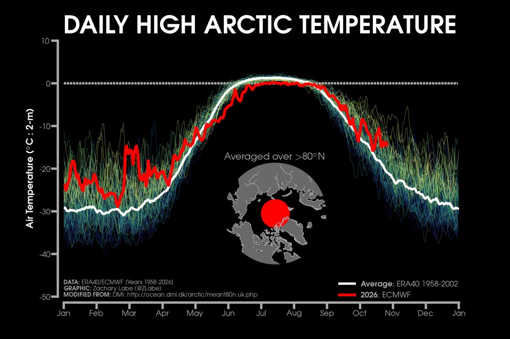
-
mexico meds: mexican pharmacy store - reliable mexican pharmacies
-
The surface-level weather effects from a Sudden Stratospheric Warming (SSW) event in the United States typically last for 2 to 6 weeks on average. [1] While a major SSW event drastically disrupts the polar vortex high up in the stratosphere, its effects do not impact ground weather immediately. Instead, there is a 10- to 20-day time lag as the atmospheric changes ripple downward to the surface, causing the jet stream to become wavy and unstable. [1, 2, 3] Once those effects arrive, the impacts on U.S. weather patterns include: Prolonged Cold Spells: Rather than a brief cold snap, the weak polar vortex patterns lock in atmospheric blocks that can extend below-average temperatures for several weeks. [1, 2] Increased Storminess: A wavy jet stream frequently shifts the storm track, increasing the likelihood of extreme precipitation and winter storms. [1, 2] Regional Variation: An SSW event does not guarantee uniform cold across the entire country. For instance, a collapsed or split polar vortex often unleashes severe cold into regions like the Northern Plains or the Midwest, while other regions like the Eastern Seaboard can occasionally experience temporary warming depending on exactly where the cold air mass migrates. Also 2009 -2010 featured a moderate to Strong El Nino BUT not as strong as this one. Along with that there was an SSW event in mid to late November and we ended up with 12 Inches of snow in December in NYC and January we had a break and ended up with 2 inches BUT we all remember what happened in February 2010 -36 Inches of snow in NYC. So 2009- 2010 is now an analog year. [1, 2, 3] The previous expectations of a back loaded winter by many might turn into a front and back loaded winter with a break in the middle in January - time will tell
-

Mountain West Discussion
mayjawintastawm replied to mayjawintastawm's topic in Central/Western States
I have come to believe strongly that "high uncertainty" means an absolute certainty that an 80% chance of precip will be manifested as wind and clouds, with a slight and temporary increase in humidity, for an hour or two.