All Activity
- Past hour
-

January 2026 regional war/obs/disco thread
40/70 Benchmark replied to Baroclinic Zone's topic in New England
Yes, "a few" generally means more than two but not many, often interpreted as 3-5, so it is more than two, but its exact number is flexible and context-dependent, though "a couple" is often used specifically for two. While some strictly define "a few" as three, it's usually understood as a small quantity greater than a pair. Key Distinctions -
January 2026 regional war/obs/disco thread
40/70 Benchmark replied to Baroclinic Zone's topic in New England
No. Dictionary Definitions from Oxford Languages · Learn more sev·er·al /ˈsev(ə)rəl/ determiner · pronoun more than two but not many. "the author of several books" Similar: some a number of -
January 2026 regional war/obs/disco thread
40/70 Benchmark replied to Baroclinic Zone's topic in New England
We should start a "county thread".....where they can virtually gather and complete the circle of prostate massage while viewing the pictures. -

January 2026 regional war/obs/disco thread
weatherwiz replied to Baroclinic Zone's topic in New England
several (I) usually refers to more than 5. Couple/few I always thought were about the same in terms of a numerical reference -
6z euro was interesting for Sunday
-
Lmaoo yeah cause that's gonna happen
-

January 2026 regional war/obs/disco thread
SouthCoastMA replied to Baroclinic Zone's topic in New England
I wish everyone could experience the feeling of extreme glee I get when snowmobile pics are posted. -

January 2026 regional war/obs/disco thread
Torch Tiger replied to Baroclinic Zone's topic in New England
at least the positivity pals have their frigid dry cold and ice fishing -
January 2026 regional war/obs/disco thread
40/70 Benchmark replied to Baroclinic Zone's topic in New England
No, a few is great than 2, just like "several" is greater than 3.....2 is a "couple". -
To all the steeler fans who kept saying the Steelers are 23-0 on Monday nights!!.... Now your 23-1! Lol
-
January 2026 regional war/obs/disco thread
weatherwiz replied to Baroclinic Zone's topic in New England
A month has 4 weeks. A few is 2...so few = 2 weeks -

January 2026 Medium/Long Range Discussion
Stormchaserchuck1 replied to snowfan's topic in Mid Atlantic
It's been a Nina STJ.. too bad because we are having our 2nd below average temp Winter in a row. Last -PDO decadal cycle was also cold and dry. -

January 2026 regional war/obs/disco thread
WinterWolf replied to Baroclinic Zone's topic in New England
You’ll get nothing and like it. Ma nature boring out your rear end…and putting you on ice as a bonus. Becoming rather comical actually. -
January 2026 Medium/Long Range Discussion
Stormchaserchuck1 replied to snowfan's topic in Mid Atlantic
Real nice -AO showing up at the end of 6z GFS ensembles Correlation with temps (default is positive so -ao is opposite) -
January 2026 regional war/obs/disco thread
WinterWolf replied to Baroclinic Zone's topic in New England
384 hour/16 day Op run…can we get any more ridiculous…that deserves a 10 Bunner. -
January 2026 regional war/obs/disco thread
40/70 Benchmark replied to Baroclinic Zone's topic in New England
Man, that PV just sits over Hudson Bay.....I absolutely nailed this month, aside from the minor detail that it won't snow in SNE-at all. -

Mid-Long Range Discussion 2026
WinstonSalemArlington replied to BooneWX's topic in Southeastern States
Bingo! The story of this winter is not a lack of cold; it’s profound drought. -
(002).thumb.png.6e3d9d46bca5fe41aab7a74871dd8af8.png)
Central PA Winter 25/26 Discussion and Obs
ChescoWx replied to MAG5035's topic in Upstate New York/Pennsylvania
Temperatures today and tomorrow will be a couple degrees above normal for mid-January with highs in the mid to upper 40's. Clouds increase later today and tomorrow with a chance of rain tomorrow evening changing to snow around midnight before ending toward Thursday morning. Any accumulations look light, but we will need to keep an eye out for some potential Thursday morning rush hour impacts. Highs on both Thursday and Friday will remain in the 20's. Below normal temperatures appear likely for much of the next week with lows next week in the single digits possible for some areas.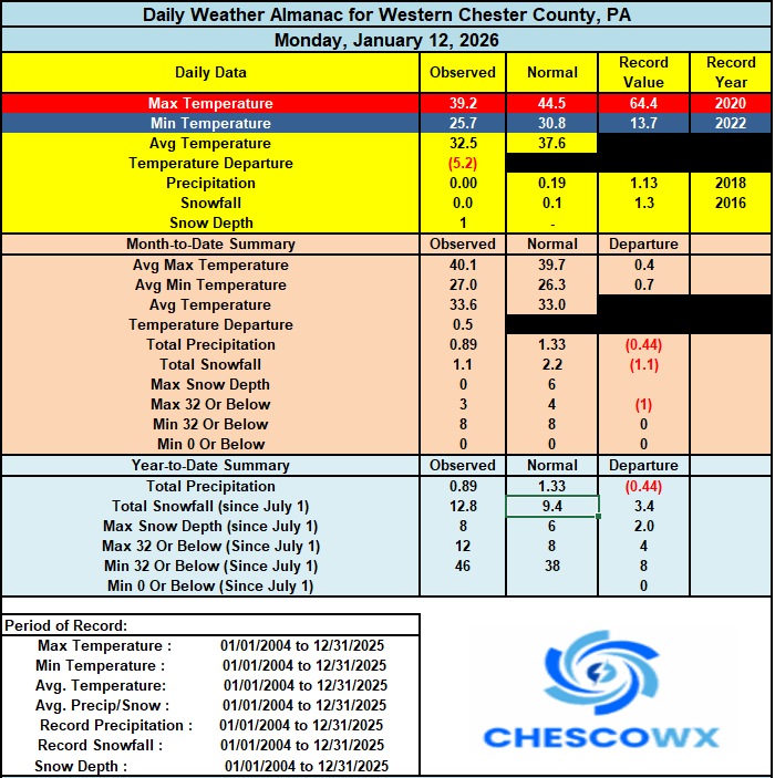
-
E PA/NJ/DE Winter 2025-26 Obs/Discussion
ChescoWx replied to LVblizzard's topic in Philadelphia Region
Temperatures today and tomorrow will be a couple degrees above normal for mid-January with highs in the mid to upper 40's. Clouds increase later today and tomorrow with a chance of rain tomorrow evening changing to snow around midnight before ending toward Thursday morning. Any accumulations look light, but we will need to keep an eye out for some potential Thursday morning rush hour impacts. Highs on both Thursday and Friday will remain in the 20's. Below normal temperatures appear likely for much of the next week with lows next week in the single digits possible for some areas.
-
Pretty tame next 7 days precip wise in the whole lower 48, outside some lake snows and light precip elsewhere. The ridge outwest has dried out California. Chicago / LA R game may be near 0
-
January 2026 regional war/obs/disco thread
40/70 Benchmark replied to Baroclinic Zone's topic in New England
I'm sure Jay Peak and the LES belts will do fine...can't wait for the pics. -
E PA/NJ/DE Winter 2025-26 Obs/Discussion
ChescoWx replied to LVblizzard's topic in Philadelphia Region
But funny they are of course still ranked as an elite team in MLB. Number 4 in MLB and 5 for ESPN. In baseball the best team rarely wins (see Phillies in 1977 / 2010-2011) you simply need to be on the playing field (in the playoffs) and get a bit lucky see 1980/2008 and 2022. The Phillies are a top tier team and have a strong chance to make the playoffs for a team record tying 5th straight season. Do I think they will win the World Series?? I never do but do I think they have a chance to be on the playing field? Yes and as a fan who has for the vast majority of my phandom found the team not even in the playoffs with zero chance....I love these years!! Go Phillies and oh yeah adding Bo Bichette would make them even better!! Land the plane Dave!! -

January 2026 regional war/obs/disco thread
CoastalWx replied to Baroclinic Zone's topic in New England
But the pictures of the depth of ice fishing holes really get my mojo going. -
Records: Highs: EWR: 70 (1932) NYC: 68 (1932) LGA: 63 (2017) JFK: 58 (2017) Lows: EWR: 0 (1981) NYC: -3 (1914) LGA: 4 (1981) JFK: 8 (1981) Historical: 1862: Known as the Great Flood of 1862, a series of storms from December 1861 to January 1862 produced the largest flood in the recorded history of Oregon, Nevada, and California. Estimated property damage in California alone was $10 million in 1862 dollars. More than 200,000 head of cattle lost their lives. The State of California went bankrupt, and the economy evolved from ranching to farm-based. The same areas are expected to be flooded again if another ARkStorm (USGS name) impacts California, which could cause over $750 billion (2011 USD), making it more disastrous than California's long-overdue major earthquake. California is currently overdue for a Megastorm, and such an event would have severe impacts on the entire U.S. economy. 1886 - A great blizzard struck the state of Kansas without warning. The storm claimed 50 to 100 lives, and eighty percent of the cattle in the state. (David Ludlum) 1888 - The mercury plunged to 65 degrees below zero at Fort Keough, located near Miles City MT. The reading stood as a record for the continental U.S. for sixty-six years. (David Ludlum) 1912 - The temperature at Oakland, MD, plunged to 40 degrees below zero to establish a state record. (Sandra and TI Richard Sanders - 1987) 1912: Cold Wave The Great Cold Wave of January 1912 a record cold wave settled in over the region. Records set in Maryland during this period remain to the present day. It was close, but not quite cold enough to break the records in Virginia set during the February 1899 "Great Arctic Outbreak". The cold wave of 1912 hit on January 5 and continued until February 16. It was one of the most severe and longest in duration on record. Ice formed on the rivers and the Chesapeake Bay. On January 13, Oakland in far western Maryland recorded the state's all time record low temperature of -40°F. In Washington, DC, it reached -8°F. On the 14th, College Park reported -26°F, Hagerstown -27°F, Frederick -21°F, Laurel -19°F, Baltimore -2°F and Washington, DC -13°F. The coldest temperatures in Virginia were -25° at Lincoln (Loudoun County) and Dale Enterprises near Harrisonburg. Fredericksburg was -11°F and Culpeper fell to -20°F. In the Eastern West Virginia Panhandle, temperature ranges were from -14° at Lost City in Hardy County to -30° at Bayard in Grant County. That makes this day one of only five days in the official climate history of Washington (11-1-1870- present) to have a maximum temperature less than 10 degrees F. The first time was on 12-30-1880 when the high was also 9 degrees F. A high temperature of 8 degrees has occurred twice - the first time was this date (1-13-1912) and the second time was 1-19-1994. The coldest maximum ever recorded in Washington, DC occurred on 2-10-1899: 4 °F(Stanley Rossen) (Ref. Wilson - Additional Temperatures Listed On This Link) 1912: An arctic cold wave struck the region with subzero temperatures. Washington, DC fell to -13°F, Quantico fell to -16°F, Fredericksburg to -11°F, Culpeper to -20°F, Loudoun County to -25°F, Woodstock to -22°F, Harrisonburg to -25°F, Staunton to -12°F and Lexington to -16°. In Rockingham and Loudoun Counties these were the coldest temperatures ever recorded. Click this link to see Map - NWS 1913: The temperature at Rapid City, SD rose 64° in 14 hours. (Ref. AccWeather Weather History) 1916: Extreme cold affected the Plains and Midwest. Bismarck, ND tied their all-time record low with -45°. Locations that reported daily record lows included: Williston, ND: -41°, International Falls, MN: -41°, Watertown, SD: -40°, Grand Rapids, ND: -40°, Huron, SD: -40°, Kennebec, SD: -39°, Wheaton, SD: -38°, Timber Lake, SD: -37°, Fargo, ND: -37°, Sioux Falls, SD: -36°, St. Cloud, MN: -35°, Duluth, MN: -33°, Valentine, NE: -30°, Minneapolis, MN: -30 °F. (Ref. Wilson - Additional Temperatures Listed On This Link) 1932: The maximum temperature for the date in Washington, DC is 75°F. (Ref. Washington Weather Records - KDCA) 1937: The Ohio River floods covered most of the town of Jeffersonville, sending 13,000 people fleeing. 90,000 people were forced to evacuate Evansville, IN. 70% of Louisville, KY was inundated. Paducah, KY was deserted in the face of the rising water. (Ref. AccWeather Weather History) 1950: January 1950 was one of the worst winter months on record for Seattle, Washington, and surrounding areas. By the end of the month, Seattle measured 57.2 inches of snow, the most snowfall in any month since records began in 1894. The normal January snowfall is 1.4 inches. On this day, a crippling blizzard produced 40 to 50 mph winds and an astounding 20 inches. 1952: During the first days of this year, the Southern Pacific Railroad found itself battling a series of fierce winter snow storms that threatened all train operations. Their flagship passenger train, the Streamliner City of San Francisco finally set out over the Sierras on this date. The train became trapped in an avalanche. It would take 3 days to free the 226 passengers. Unfortunately, two rescuers perished.(Ref. AccWeather Weather History) 1964: A large, slow moving snowstorm hit the Mid Atlantic PA was hit the hardest. Williamsport, PA was buried under 24 inches of snow. Scranton, PA checked in with 19 inches and Nantucket, MA recorded 19 inches(Ref. Wilson Wx. History) Ref. (NWS Ranking for Storms between 1956 and 2011) This is the 6th Worst Snowstorm 1972: An elementary school in suburban Atlanta was struck by lightning, sparking a fire. The students had to evacuate the building into the raging storm. (Ref. AccWeather Weather History) 1979: A massive blizzard dumps heavy snow across southern Lower Michigan. Temperatures in the teens and strong winds lead to heavy drifting of the powdery snow, causing travel to come to a halt. The snow, at times falling at more than an inch an hour, caused power outages due to broken tree limbs. Snow accumulations were up to 3 feet, causing some roofs to collapse. South Haven, MI had 21 inches of new snow added to 24 inches already on the ground. Chicago, IL reported 16.5 inches with up to two feet around town. Grand Rapids, MI saw 13.5 inches of snow and 2 to 4 foot drifts with wind gusts between 25 and 35 mph. Peoria, IL reported 12.2 inches and Rockford, IL checked in with 9.5 inches. (Ref. Wilson Wx. History) 1987 - Dry and mild weather prevailed across the country. Nineteen cities in the Upper Midwest reported record high temperatures for the date, including Grand Island NE with a reading of 67 degrees. (National Weather Summary) 1988 - A fast moving cold front ushered arctic cold into the north central and northeastern U.S. Mason City IA reported a wind chill reading of 51 degrees below zero, and Greenville ME reported a wind chill of 63 degrees below zero. Winds along the cold front gusted to 63 mph at Rochester NY, and a thunderstorm along the cold front produced wind gusts to 62 mph at Buffalo NY, along with snow and sleet. (National Weather Summary) 1989 - Friday the 13th was bad luck primarily for the south central U.S. as an upper level weather disturbance spread a mixture of snow and sleet and freezing rain across Texas and Oklahoma. Snowfall totals in central Oklahoma ranged up to 8.5 inches at Norman. (National Weather Summary) (Storm Data) 1990 - A winter storm in the southwestern U.S. produced more than a twelve inches of snow in the mountains of California and Nevada. In northern California, Huntington Lake was buried under 40 inches of snow, and up to 20 inches was reported in northeastern Nevada. Heavy rain soaked some of the lower elevations of California. Gibraltar Dam CA was drenched with 5.33 inches of rain in two days. (National Weather Summary) (Storm Data) 1996: The eastern half of Pennsylvania was reeling under its heaviest snow cover in memory. The area around the state capital had nearly 4 feet of snow on the ground. Parts of the northern Susquehanna Valley had nearly 5 feet of snow cover. Six days later, most of the snow would melt and combine with an unseasonably warm rainstorm to produce the worst flooding since Hurricane Eloise in 1975. (Ref. Wilson Wx. History)
-
Haven’t checked in since the quick start to the season but I’m happy to report my area is back to the same old recent winters. Warm up and mud followed by big temp drops and ice. The ever cloudy skies are a nice touch as well


