All Activity
- Past hour
-
46 here!
-

Strong Nor'Easter/Hybrid Storm Late September 2026
SnoSki14 replied to Rjay's topic in New York City Metro
It'll be very banding oriented rather than steady rain. -

October Comes Early: Late September Multi-Hazard Hybrid Storm
dendrite replied to WxWatcher007's topic in New England
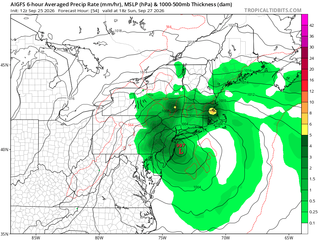
Averaged over 6hr. His problem is it’s mm and not inches. So that’s about 1.5” in that orange pixel. -

Strong Nor'Easter/Hybrid Storm Late September 2026
jm1220 replied to Rjay's topic in New York City Metro
I’m sure the back bays are getting wrecked pretty good from this. There’s wave/water rise over multiple tide cycles plus full moon. -
 canadian pharmacy online and vipps approved canadian online pharmacy best online canadian pharmacy https://images.google.sm/url?sa=t&url=https://canamcrosscare.com my canadian pharmacy and http://ussher.org.uk/user/tezqcdgcqw/?um_action=edit canadian pharmacies that deliver to the us [url=https://images.google.ci/url?q=https://canamcrosscare.com]canada pharmacy[/url] canadian pharmacy website and [url=https://brueckrachdorf.de/user/tslqfkonix/]canada drug pharmacy[/url] canadian pharmacy store
 -
Despite abnormally dry conditions, the color change is not disappointing this year. Chilly nights and mild to cool sunny days have led to nearly ideal conditions the past few weeks. Probably will see peak conditions over the weekend and early next week. Standard iPhone camera setting. No edits or enhancements.

.thumb.jpg.b08728a35220787429bc6daadb4fcbd0.jpg)
.thumb.jpg.e68b8a30ff40da858b9f9f5b9f0b80db.jpg)
-

October Comes Early: Late September Multi-Hazard Hybrid Storm
WxWatcher007 replied to WxWatcher007's topic in New England
-

October Comes Early: Late September Multi-Hazard Hybrid Storm
CoastalWx replied to WxWatcher007's topic in New England
That’s precip rate -
The ocean was called for, and it came
-
October Comes Early: Late September Multi-Hazard Hybrid Storm
CoastalWx replied to WxWatcher007's topic in New England
Yeah naked swirl. Wonder if a new center redevelops? -

October Comes Early: Late September Multi-Hazard Hybrid Storm
Ginx snewx replied to WxWatcher007's topic in New England
6 inches in 6 hrs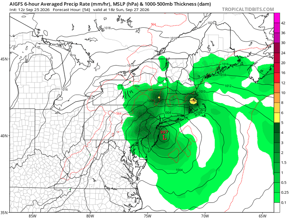
-

October Comes Early: Late September Multi-Hazard Hybrid Storm
Typhoon Tip replied to WxWatcher007's topic in New England
Does seem like the lower tropospheric foot of the cyclone's currently snipped off the warm front and drifting just by impression of satellite. -
Sucks but to be expected given the forecast.
-

Strong Nor'Easter/Hybrid Storm Late September 2026
jbenedet replied to Rjay's topic in New York City Metro
Much warmer SST’s than with sandy also affect thermal expansion and higher sea level. A marginal factor but another consideration… -

Strong Nor'Easter/Hybrid Storm Late September 2026
Winter Wizard replied to Rjay's topic in New York City Metro
-

Strong Nor'Easter/Hybrid Storm Late September 2026
Yanksfan replied to Rjay's topic in New York City Metro
Sandy barely gave me any rain at all. -
October Comes Early: Late September Multi-Hazard Hybrid Storm
Ginx snewx replied to WxWatcher007's topic in New England
Thanks will be handy coming winter -
October Comes Early: Late September Multi-Hazard Hybrid Storm
CoastalWx replied to WxWatcher007's topic in New England
I don’t know if this setup will produce that, but heavy rains sure. -
Strong Nor'Easter/Hybrid Storm Late September 2026
Winter Wizard replied to Rjay's topic in New York City Metro
The only similarities between this storm and Sandy are they're both occurring at high tide and to an extent retrograding westward. Sandy is going to be 40-50 mb stronger and several times larger in diameter and wind field. This isn't even in the same league. Having said that, I do think the coastal flooding in some areas may end up getting close to those levels, particularly on Long Island, Raritan Bay, and parts of the Jersey Shore. -
October Comes Early: Late September Multi-Hazard Hybrid Storm
Ginx snewx replied to WxWatcher007's topic in New England
Except it comes in Exceptionally wet banding. You could pick up 4 inches in 90 minutes -

Strong Nor'Easter/Hybrid Storm Late September 2026
winterwx21 replied to Rjay's topic in New York City Metro
GFS gives us a pretty good soaking tomorrow too before the main event. I wonder if that's right because some of the mesoscale models say we're not gonna see much rain during the day tomorrow. -
October Comes Early: Late September Multi-Hazard Hybrid Storm
Ginx snewx replied to WxWatcher007's topic in New England
Fixed yes API. Missing data was dragging it down. Thanks Mike -

October Comes Early: Late September Multi-Hazard Hybrid Storm
DirtySnowDen replied to WxWatcher007's topic in New England
Remember it’s meteorology and not modelogy, that low pressure is already lapping up the cold air as it sits over warm-ish water. It’s gonna force the high to weaken and split, funneling the same low pressure at the same time. -
 Bookmarked, site is beautiful Sent from my SM-S176V using Tapatalk
 -
So refreshing outside. Sucks we will be back near 85+ the mid to end next week. Ugh. Got down to 50* here last night. Wish we can bottle this up for the next month or so.




.jpg.de5daa8751f7df27dd900c0f86ca5d89.jpg)
.jpg.4a675ad0a7a50be6d4f956b139e9d067.jpg)