All Activity
- Past hour
-

26th-27th event, coming at us like a wounded duck.
weatherwiz replied to Go Kart Mozart's topic in New England
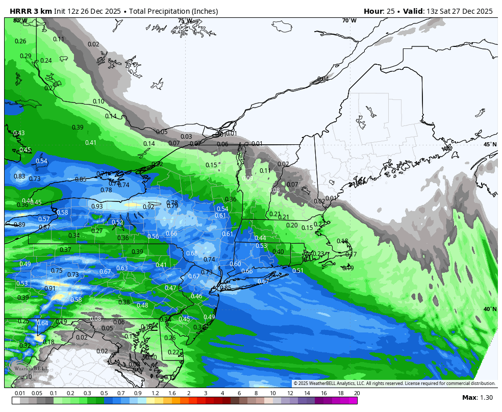
Under the banding the snowfall rates would probably approach 2"/hr and maybe even upwards of 2.5". Feasibly, because of the crosshair signature (the -30 dissecting the snow growth zone) that should elicit great snowgrowth...the dendrites which accumulate quickly. I am a little worried though we may not get the perfect dendrites and snow growth will be a bit impacted by some dry air. The big question is what happens outside of the banding...that's where there could be more of a struggle and if we end up with multiple band signatures there will be some screw zones. In between these, perhaps even outside the banding, this is where you'll get more in the way of Arctic dust. Regardless, a widespread 4-7" is still in the cards but we need to be mindful there will be some screw zones. I don't think we'll see many totals eclipse 7-8" only because its really a 3 hour period of heavy accumulating snow and that's it. This is going to be fun to track in real time -

Central PA Winter 25/26 Discussion and Obs
canderson replied to MAG5035's topic in Upstate New York/Pennsylvania
Remember kids, don’t clear sleet until this event is over. ZR on sleet = manageable, zr on asphalt = bad timed -
Found it interesting that this was another event where a couple AI models kinda sniffed out the trend a run or two before the globals. That said, I think the Euro got its shine on this one.
-
This looks right to me, I would bump KNYC to 2.5 lol
-
I had a house full yesterday and was busy enjoying that, did look at much model stiff or help monitor the posters coming out of the woodwork, as is tradition before a snowstorm. Anyway, I would think we will at least see some flakes before 6pm.
-

Central PA Winter 25/26 Discussion and Obs
WmsptWx replied to MAG5035's topic in Upstate New York/Pennsylvania
That is Steven DiMartino from... Freehold, NJ. -

26th-27th event, coming at us like a wounded duck.
Sey-Mour Snow replied to Go Kart Mozart's topic in New England

-

26th-27th event, coming at us like a wounded duck.
Damage In Tolland replied to Go Kart Mozart's topic in New England
Should hold onto solid pack almost everyone with ice to Cold rain -
How did the 6z EURO look.
-
The end of the 6z gefs looks like it is a day or 2 from that JMA look. EPS also. GEFS
-
EWR: 5.2 JFK: 4.8 LGA: 6.8 MMU: 4.1 POU: 11.3 HPN: 7.6 Upton: 7.2 KNYC: Trace
-

26th-27th event, coming at us like a wounded duck.
radarman replied to Go Kart Mozart's topic in New England
Agree about the dry air... what might sometimes be small flakes in a subsidence zone w/ a heavy band to the west will just sublimate entirely. Brief heavy burst should yield an inch or two. -

26th-27th event, coming at us like a wounded duck.
CoastalWx replied to Go Kart Mozart's topic in New England
Of course it melts two days later. -
WSW for 5-9” out this way. Pretty easy forecast for central LI. much harder for NJ/CT/MA
-
26th-27th event, coming at us like a wounded duck.
Damage In Tolland replied to Go Kart Mozart's topic in New England
He pulled out a drawing compass with circles and graphs to find two cities with the perfect line to “exquisitely “ leave Tolland out -
26th-27th event, coming at us like a wounded duck.
CoastalWx replied to Go Kart Mozart's topic in New England
We Pastrami on Rye -

26th-27th event, coming at us like a wounded duck.
WinterWolf replied to Go Kart Mozart's topic in New England
Snowgoose said a while back…GFS may not be off it’s rocker this go around. -
Its not a strong storm for sleet to rush in. We should be fine.
-

26th-27th event, coming at us like a wounded duck.
EastonSN+ replied to Go Kart Mozart's topic in New England
Seems Upton expanded the WSW south into New Jersey rather than to EOR. In any event it looks like pur area CT is in the best spot if we blend all the guidance. -

Boxing Night Snow/Sleet/Ice Dec 26-27 Storm Thread/Obs.
systemfreeze64 replied to Mikeymac5306's topic in Philadelphia Region
Just got approved to join yesterday, hoping for at least 3" of snow here in Allentown, PA but it'll be close with the amount of sleet it looks like we're set to get. -

26th-27th event, coming at us like a wounded duck.
Brian5671 replied to Go Kart Mozart's topic in New England
Upton has 5-9 here-depends on banding. GFS is a wet outlier which is quite unusual -
26th-27th event, coming at us like a wounded duck.
Damage In Tolland replied to Go Kart Mozart's topic in New England
I think 6+ is virtually a lock here TBH -
26th-27th event, coming at us like a wounded duck.
WinterWolf replied to Go Kart Mozart's topic in New England
So what’s that mean Paul? Great snow growth? -

Central PA Winter 25/26 Discussion and Obs
mitchnick replied to MAG5035's topic in Upstate New York/Pennsylvania
All ensemble snowfall imby are horrendous with 1-2". I know they aren't accurate, but usually because they are too high! That's the problem! Lol -
26th-27th event, coming at us like a wounded duck.
EastonSN+ replied to Go Kart Mozart's topic in New England
Seems to be expanding the snow shield in lieu of moving north. Here is SW CT it appears the snow amount has not dropped off.