All Activity
- Past hour
-
You must be new
-

2025-2026 ENSO
donsutherland1 replied to 40/70 Benchmark's topic in Weather Forecasting and Discussion
Right now, the long-range European guidance is suggesting the development of a Scandinavian Block near mid-December onward. That's not an AO-. Your location should be ok. Things should also be ok for cities such as Chicago, Detroit, Toronto, Ottawa, Montreal, etc. If the AO is more positive, areas south of New England would typically see a warmer outcome with reduced snowfall prospects. The SE U.S. looks warm, overall, for December.

-

Fall 2025 Medium/Long Range Discussion
Chicago Storm replied to Chicago Storm's topic in Lakes/Ohio Valley
stop looking at the op gfs. -

December 2025 Short/Medium Range Forecast Thread
Carvers Gap replied to John1122's topic in Tennessee Valley
And the 12z CMC has similar look to both the AIFS and GFS. EPO anyone? -

November 2025 general discussions and probable topic derailings ...
ORH_wxman replied to Typhoon Tip's topic in New England
12z GFS def had several chances in the long range. That period after about 12/2 gets pretty interesting. There’s still risk that we end up on the warm side but I like seeing a lot of reinforcing PV shots into SE Canada…that’s ultimately what will give us the confluence and antecedent airmass we need. So the more reinforcing shots that we see on guidance, the better our chances. -
December 2025 Short/Medium Range Forecast Thread
Carvers Gap replied to John1122's topic in Tennessee Valley
The 12z CMC has a below zero air mass sitting in the Plains and Ohio River Valley as a couple of impulses originate in the Gulf and head northeastward. -

2025-2026 ENSO
TheClimateChanger replied to 40/70 Benchmark's topic in Weather Forecasting and Discussion
-
December 2025 Short/Medium Range Forecast Thread
Carvers Gap replied to John1122's topic in Tennessee Valley
The 12z CMC almost has a winter storm by 198. Big changes on the deterministic models at 12z today - noted that the Euro has yet to run. The Euro AIFS, GFS, and CMC are showing a cold shot around d10-12 which wasn't there on yesterday's runs. It is a bruiser. I doubt the ensembles will switch that quickly, but it is a trend worth watching. This cold front had been on LR ext modeling for weeks, and then disappeared. edit...the CMC is actually close to something good 3x. -
Yeah we just have a crusty couple inches in the yard and the fields are melted out. Highly elevation dependent start to winter. Only saw 3” total 24 hrs at all plots at Mansfield, like you said.
-
Yeah I mean it’s early. It’s hitting like late January pessimism. Canadian further south [emoji2957].
-
Upslope was a dud..probably about 3” total..big difference from valleys near jay like Montgomery and Stowe village at 750’ in snow cover. Mansfield is in good shape tho, but can’t see shit at the top. .
-
2025-2026 ENSO
TheClimateChanger replied to 40/70 Benchmark's topic in Weather Forecasting and Discussion
Incredible stuff, with NHEM anomalies pushing up towards 2C above the 1981-2010 mean as we head towards the end of the month. This has been one heck of a hemispheric heat wave over the last month or so. -
The only forecast i trust is @Ellinwood.
-
CMC has storm as well.
-
Like the great MLK once said, I had a dream (just mine was dirty).
-
December 2025 Short/Medium Range Forecast Thread
Carvers Gap replied to John1122's topic in Tennessee Valley
The 12z Euro AIF is rolling. You can send me the Christmas card later (for saying the first week of December being warm was a foregone conclusion). LOL. That right there is not a warm look for the eastern 2/3 of North America. -

Fall 2025 Medium/Long Range Discussion
sbnwx85 replied to Chicago Storm's topic in Lakes/Ohio Valley
To be fair you are in peak form for November. -
December 2025 Short/Medium Range Forecast Thread
Carvers Gap replied to John1122's topic in Tennessee Valley
And this would be phase 8. Now, I must warn everyone(newbies especially) that model talk past d10 is not without peril. But it sure seems like the GFS (and about half of the recent AIFS runs) are sniffing out a potential cold shot around December 6th. -
2025-2026 ENSO
donsutherland1 replied to 40/70 Benchmark's topic in Weather Forecasting and Discussion
Yes. I agree. I think only the timing of its onset remains to be seen. -
December 2025 Short/Medium Range Forecast Thread
Carvers Gap replied to John1122's topic in Tennessee Valley
And this is a setup that says, "Look out!" This is sitting at d10. As @Holston_River_Ramblershared yesterday, the AIFS caught wind of this possibility first - I failed to note that early...sorry Holston! The GFS is now picking up on the possibility. That is a mechanism for fiercely cold air to be discharged into the Lower 48, especially the Northern Plains, Ohio River Valley, and maybe the Tenn River Valley. There is the possibility that this is being under done. Either way, this is a very cold look at the surface. -
The primary drives up into Pittsburgh and everyone flips.
-
It happens more than you think. There is absolutely no QA/QC for weather apps. I would love to see something like American Meteorological Society or National Weather Association offer a "seal of approval" for apps that maintain things like updates, appropriate warning information, etc. Worse yet, certain apps like Operating System based platforms are largely not customizable and default to the organizational settings. All of these work to undermine the credibility of weather apps and unfairly degrade the ethos of the meteorological community.
-
SoMD would be sweating the rain/snow line for the whole event. That's what I want to see, the big ones are always a stressful event down here.
-
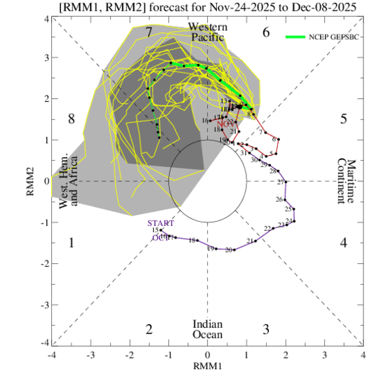
When I type on Google asking about the major SSW will it be either reflective or absorptive the answer has changed before it said reflective now it's saying a combined reflective- absorptive event. Starting out as a reflective phase transitioning into an absorptive phase. Which is why the AO is turning positive with the reflective phase then it will transition mid to late December into the absorptive phase which will flip the AO and NAO both negative. This information is compiled by numerous sources. So December is far from toast. The GEFS shows the MJO going into phase 8. Since, someone is confused I am going to copy the information here. AI Overview The major Sudden Stratospheric Warming (SSW) event forecast for late November and early December 2025 is anticipated to be a potential combined reflective-absorptive event. According to current meteorological models and expert analysis, the event exhibits characteristics of both types, which will influence the timing and location of the resulting weather impacts. Event Type and Expected Progression Initial Reflective Phase (Near-term/Early December): The initial phase is expected to be dominated by wave reflection, where upward-propagating planetary waves temporarily bounce off the disturbed polar vortex. Effect: This phase will likely temporarily strengthen the stratospheric polar vortex and accelerate the polar jet stream, leading to a positive Arctic Oscillation (AO) and North Atlantic Oscillation (NAO) and stronger westerlies across northern Europe in the short term. Surface Response: This might result in a temporary Alaskan Ridge (AkR) development in the Pacific. Subsequent Absorptive Phase (Medium-term/Mid-late December): The reflective phase is expected to be followed by a dominant absorptive phase, where the waves are subsequently absorbed, leading to a breakdown or displacement of the polar vortex and the downward propagation of wave activity to the troposphere. Effect: This absorption will increase pattern uncertainty and is the phase typically associated with a weakened polar vortex, which allows frigid Arctic air to plunge south into lower latitudes. Surface Response: This second phase is expected to lead to cold air outbreaks and potential snow events across parts of the United States, Canada, and Europe as the polar vortex becomes disrupted. The specific classification as a combined event highlights the complexity of this particular SSW and suggests a dynamic, multi-phase impact on Northern Hemisphere winter weather patterns. https://www.linkedin.com/posts/jens-bonewitz-b43002142_potential-ssw-wave-activity-7398315457403064320-w1Uq#:~:text=Jens Bonewitz's Post-,Jens Bonewitz,uncertainty as absorption phase dominates.
-
Exactly Our forecasting system is broken but many cling to it quite vociferously. Some can navigate impressively getting stations installed on public and private lands, they have talent and contacts and expert execution. I wish they would apply that talent to NOAA and NWS and bring about change. I’ve offered suggestions and not just complaints. But I’m a minority voice in that