All Activity
- Past hour
-
 Looks like max was 91 degrees at 2:25.
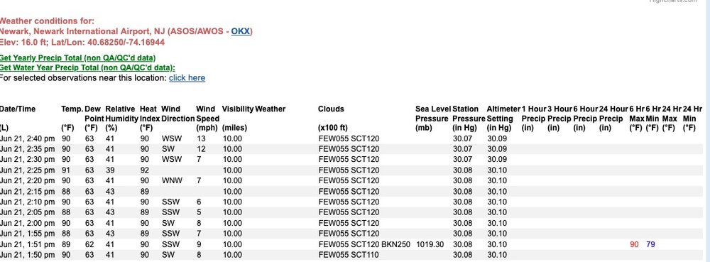
-
URGENT - WEATHER MESSAGE National Weather Service Baltimore MD/Washington DC 244 PM EDT Sat Jun 21 2025 MDZ003-VAZ027>031-WVZ052-053-220245- /O.NEW.KLWX.HT.Y.0001.250622T1600Z-250623T0000Z/ /O.NEW.KLWX.XH.A.0001.250623T1500Z-250624T0100Z/ Washington-Shenandoah-Frederick VA-Page-Warren-Clarke-Berkeley- Jefferson- 244 PM EDT Sat Jun 21 2025 ...HEAT ADVISORY IN EFFECT FROM NOON TO 8 PM EDT SUNDAY... ...EXTREME HEAT WATCH IN EFFECT FROM MONDAY MORNING THROUGH MONDAY EVENING... * WHAT...For the Heat Advisory, heat index values up to 103 expected. For the Extreme Heat Watch, dangerously hot conditions with heat index values up to 107 possible. * WHERE...In Maryland, Washington County. In Virginia, Clarke, Frederick, Page, Shenandoah, and Warren Counties. In West Virginia, Berkeley and Jefferson Counties. * WHEN...For the Heat Advisory, from noon to 8 PM EDT Sunday. For the Extreme Heat Watch, from late Monday morning through Monday evening. * IMPACTS...Heat related illnesses increase significantly during extreme heat and high humidity events. Hot temperatures and high humidity may cause heat illnesses. PRECAUTIONARY/PREPAREDNESS ACTIONS... Drink plenty of fluids, stay in an air-conditioned room, stay out of the sun, and check up on relatives and neighbors.
-
URGENT - WEATHER MESSAGE National Weather Service Baltimore MD/Washington DC 244 PM EDT Sat Jun 21 2025 MDZ502-WVZ050-051-055-502-504-220245- /O.NEW.KLWX.HT.Y.0001.250622T1600Z-250623T0000Z/ Central and Eastern Allegany-Hampshire-Morgan-Hardy-Eastern Grant- Eastern Mineral- 244 PM EDT Sat Jun 21 2025 ...HEAT ADVISORY IN EFFECT FROM NOON TO 8 PM EDT SUNDAY... * WHAT...Heat index values up to 102 expected in the valleys. * WHERE...In Maryland, Central and Eastern Allegany County. In West Virginia, Eastern Grant, Eastern Mineral, Hampshire, Hardy, and Morgan Counties. * WHEN...From noon to 8 PM EDT Sunday. * IMPACTS...Hot temperatures and high humidity may cause heat illnesses. PRECAUTIONARY/PREPAREDNESS ACTIONS... Drink plenty of fluids, stay in an air-conditioned room, stay out of the sun, and check up on relatives and neighbors.
-
URGENT - WEATHER MESSAGE National Weather Service Baltimore MD/Washington DC 244 PM EDT Sat Jun 21 2025 DCZ001-MDZ004>006-008-011-013-014-016-503>508-VAZ053>055-502-505-506- 526-527-220245- /O.NEW.KLWX.XH.A.0001.250623T1500Z-250624T0100Z/ District of Columbia-Frederick MD-Carroll-Northern Baltimore- Cecil-Southern Baltimore-Prince Georges-Anne Arundel-Charles- Northwest Montgomery-Central and Southeast Montgomery-Northwest Howard-Central and Southeast Howard-Northwest Harford-Southeast Harford-Fairfax-Arlington/Falls Church/Alexandria-Stafford- Southern Fauquier-Western Loudoun-Eastern Loudoun-Northwest Prince William-Central and Southeast Prince William/Manassas/Manassas Park- 244 PM EDT Sat Jun 21 2025 ...EXTREME HEAT WATCH IN EFFECT FROM MONDAY MORNING THROUGH MONDAY EVENING... * WHAT...Dangerously hot conditions with heat index values up to 110 possible. * WHERE...Washington DC, and portions of central and northern Maryland, and northern Virginia. * WHEN...From late Monday morning through Monday evening. * IMPACTS...Heat related illnesses increase significantly during extreme heat and high humidity events. PRECAUTIONARY/PREPAREDNESS ACTIONS... Drink plenty of fluids, stay in an air-conditioned room, stay out of the sun, and check up on relatives and neighbors.
-
wait you have JFK listed twice Tony, actually three times but only with two different temperatures lol
-
90 here at 2:30 perhaps JFK gets it in between hours
-
 it hit 90 here at 2:30 nice offshore breeze
 -
Uptick in cloud cover here recently, even saw a stray shower on the radar NW of here and a boundary near the beaches and in lower DE.
-
Most likely scenario is no storms but debris clouds ruining big heat tomorrow
-
Glenmoore with records back to 2012 has recorded 7 heat waves in the last 13 summers. Those occurring in 2013 / 2016 / 2020/ 2022 and 3 times just last summer in 2024.
-

E PA/NJ/DE Summer 2025 Obs/Discussion
ChescoWx replied to Hurricane Agnes's topic in Philadelphia Region
Glenmoore with records back to 2012 has recorded 7 heat waves in the last 13 summers with those occurring in 2013 / 2016 / 2020 / 2022 and 3 times just last summer in 2024. -
Timing sucks. Too bad it couldn’t come through 4-6 hrs later. It slowed a bit too.
-
Marginal…for now…very interesting nowcast coming up. Northeast... A somewhat complex severe weather scenario exists for the Northeast, from Sunday morning into the afternoon hours. Scattered strong thunderstorms (perhaps a remnant MCS) may cross from southeastern Ontario and progress toward the Hudson Valley region during the morning. Should this occur, convective restrengthening is possible along the leading edge of outflow over the Mid Atlantic, with strong to potentially severe wind gusts likely. However, if convection moving into the Northeast by Sunday morning is less robust, convective re-intensification may be more likely farther north into southern New England. A more focused severe threat would be highly dependent on the placement and evolution of earlier convection/MCS morphology across Ontario during the late Day 1 period, which currently has low predictability. Despite weak vertical wind shear, of concern is the eastward advection of a modest EML into the Northeast, which may boost MLCAPE well over 3000 J/kg (perhaps over 4000 J/kg locally). Higher severe probabilities may be needed if confidence in the placement and/or timing of more organized convection increases.
-
 Newark I think hit 90 before 2PM
 -
2PM EWR: 89 PHL: 89 JFK: 89 New Brnswck: 88 BLM: 87 LGA: 87 TTN: 87 JFK: 86 TEB: 86 JFK: 86 NYC: 85 ISP: 84
-
Perfect. Thank you very much Don!
-
we just hit 90 here at 2:30 pm
-
We just hit 90 here at 2:30 pm
-
I was not expecting to be in a MRGL tomorrow, and most CAMs show no threat to our area at all, *but* there is a scenario in which the MCS that move into upstate NY (and possibly northern New England) late tonight leaves an outflow boundary over northeast PA or central NY, and a new convective complex initiates there and races south-southwest. The idea is best represented by today's 12Z HiResW ARW and to a lesser extent by the HiResW ARW2. It's certainly not likely at this point, and even if it happened, it might die as it arrives, but there is certainly at least some small potential for a surprise event, especially for northeast MD.
- 1,175 replies
-
- 2
-

-

-
- severe
- thunderstorms
- (and 2 more)
-
86 just after 2pm. Not sure its going to make it to 90 today.
-
Car Thermometer.

-
E PA/NJ/DE Summer 2025 Obs/Discussion
ChescoWx replied to Hurricane Agnes's topic in Philadelphia Region
Detail on those other 2 relatively high elevation stations in Chester County where heat waves are so rare. West Grove with data back to 2009 has also only recorded 5 heatwaves - occurring in 2011 /2012 (2x) / 2013 and the last time back in 2018. Also over at Atgen with data back to 2012 - only 3 times in the last 13 summers have they recorded a heat wave - those being in 2013 /2023 and 2024. -
should be one for Nassau County too
-
and it's hard to believe it did not hit 100 at JFK in between hours on this date, when it was 99 on a SSW wind and then the wind switched to WSW and it was 99 for two more hours.....
-
Perfect. Thank you very much Don!


