All Activity
- Past hour
-
At 126hrs, there's a surface High of 1029 in northern Iowa that wasn't ther at 12z. That's good.
-

December 2025 Short/Medium Range Forecast Thread
jaxjagman replied to John1122's topic in Tennessee Valley
GTH Outlook Discussion Last Updated - 11/25/25 Valid - 12/03/25 - 12/16/25 Recent observations of tropical convection and the global tropical circulation indicate that the Madden-Julian Oscillation (MJO) remains active, with the enhanced convective phase over the West Pacific. Little eastward propagation was evident on the RMM-based MJO index during the past two weeks, however, fluctuations in amplitude are indicative of interference from other modes of variability. The biggest disruptor to the ongoing MJO evolution is the low-frequency La Niña base state, which is preventing upper-level easterlies, low-level westerlies, and widespread convection from crossing the equatorial central Pacific. Enhanced convection is crossing the central Pacific away from the Equator, however, especially along the South Pacific Convergence Zone (SPCZ) region. Time-longitude analyses of the low-level zonal wind field reveals two distinct features propagating eastward: a slowly evolving envelope of westerly anomalies that has progressed from the Indian Ocean in October to the far western Pacific by mid- to late November, and a faster moving signal, likely Kelvin wave activity, that is circumnavigating the globe. As this latter signal comes into phase with the slower evolving signal, westerly wind bursts have occurred, followed by a period of increasing disorganization. Dynamical model forecasts are in good agreement that a period of constructive interference between these two signals will occur in late November and early December, resulting in a disruption of the La Niña trade wind regime over the west-central Pacific, and a rapid amplification of the RMM-based MJO index in Phase-7. Beyond this period, the faster moving mode becomes more unpredictable and may not well capture an easterly phase of the Kelvin wave, but the slower-evolving low-level westerlies are favored to continue impacting the Pacific basin into mid-December. A potential second enhancement of the MJO signal is clearly depicted in both the GEFS and ECMWF model systems during late December over the East Pacific, likely tied to another period of constructive interference between the slowly propagating signal and the Kelvin wave activity. Based on this guidance, the MJO is favored to remain active, and may become the dominant contributor to the global tropical convective pattern during early December. Pacific MJO events teleconnect well with the midlatitude circulation during the Boreal winter season, and may contribute to a reinforcement of ridging across western North America and troughing over eastern North America. https://www.cpc.ncep.noaa.gov/products/precip/CWlink/ghaz/index.php -

November 2025 general discussions and probable topic derailings ...
Torch Tiger replied to Typhoon Tip's topic in New England
Some said 40's...cold press..models shifting...we just don't know...yada -
Gonna be way too amped. So EURO and GFS in opposite worlds.
-
Still stronger at 123 hrs which is translating to a better precip shield than 12z
-
Regarding today’s Euro Weeklies, it’s the most bullish (i.e., colder changes vs prior run) overall in a long time in the NE and SE. I’m not they’re cold in the SE, , but they are colder than they were/not as mild or not mild overall. I don’t have time to post details right now, but y’all check it out! Or someone else please post the maps.
-
18z GFS might be good.. I wish other models would join the party..
-
At 114hrs, 18z Gfs vort is stronger than 12z fwiw.
-
Down to 39. Steady march to freezing.
-

December 2025 regional war/obs/disco thread
Ginx snewx replied to Torch Tiger's topic in New England
69 in a couple months. WTF golden years my ass -
i need two feet of snow to be happy and 36 hour dumping!
-

December 2025 regional war/obs/disco thread
Baroclinic Zone replied to Torch Tiger's topic in New England
It’s because we ARE old. -
December 2025 regional war/obs/disco thread
Ginx snewx replied to Torch Tiger's topic in New England
Could be belly to belly month -
December 2025 regional war/obs/disco thread
Ginx snewx replied to Torch Tiger's topic in New England
Heavy Heavy sleet as well. There are 2 weather days when I turned the TV on and said WTF and was so jealous . T day Dallas and Foxboro private snow storm. Had no clue. -
I’m just drinking cause I wanna. Gonna have some spiked egg nog later to kick off the holiday weekend
-
73 for the high. Torching. Where’s the front?
-

December 2025 regional war/obs/disco thread
HoarfrostHubb replied to Torch Tiger's topic in New England
A good December would be appreciated -

December 2025 Short/Medium Range Forecast Thread
John1122 replied to John1122's topic in Tennessee Valley
Thank you for the clarification! -
December 2025 regional war/obs/disco thread
HoarfrostHubb replied to Torch Tiger's topic in New England
Yeah. I was watching a video of it earlier and that’s what prompted me to ask -

December 2025 regional war/obs/disco thread
BombsAway1288 replied to Torch Tiger's topic in New England
I believe that November one was the Thanksgiving game and there was snow covering the field in Dallas freakin Texas of all places -
December 2025 regional war/obs/disco thread
Ginx snewx replied to Torch Tiger's topic in New England
Love it old school. -

December 2025 Short/Medium Range Forecast Thread
GaWx replied to John1122's topic in Tennessee Valley
Hey John, Thanks for bringing up the amp. What you said generally coincides with my thoughts. But I’d like to clarify what I’ve said just to make sure there’s not a misunderstanding. Indeed, various analyses I’ve done over the last 10-11 years or so, which all have involved calculations of actual temperatures in a place or places in the E US, have shown that the average anomalies have tended to be colder with low to moderate amp (1.7 or lower in my latest study, which was 8+ day long phase 8s) vs strong AMO of phase 8. But not “essentially every low amp pass”. It’s more like a majority of low amp have been cold vs pretty balanced for high amp. -
Now if that takes an A track over Atlanta then DC looks good and if it cuts and then supposedly transfers we might get some warm front overrunning snow and then drizzle
-
December 2025 regional war/obs/disco thread
Ginx snewx replied to Torch Tiger's topic in New England
No no just covering bases as I don't know you. Sorry -

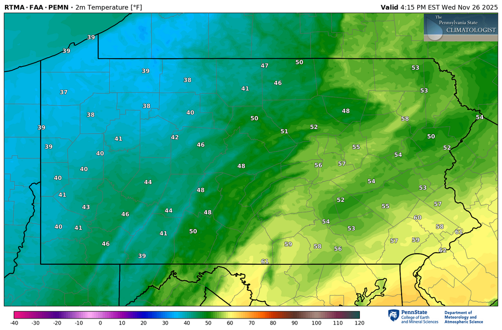
Central PA Fall Discussions and Obs
simbasad2 replied to ChescoWx's topic in Upstate New York/Pennsylvania
Here comes the cold front. 30s in western Pennsylvania; still rocking lower 60s in east Pennsylvania. Heavy showers and perhaps a rumble of thunder will accompany these storms!!