All Activity
- Past hour
-

2025-2026 ENSO
40/70 Benchmark replied to 40/70 Benchmark's topic in Weather Forecasting and Discussion
This makes sense to me....which is why I don't have an issue with a 2022-2023 type of evolution because I think a more pedestrian RNA in a regime like that would yield respectable snowfall. The +NAO anaomaly I feel will be stronger than the -PNA, but I don't think its wall-to-wall, as I am getting some signals for some early and late seasons blocking potential. -

2025-2026 ENSO
Stormchaserchuck1 replied to 40/70 Benchmark's topic in Weather Forecasting and Discussion
There really hasn't been a strong/persistent Aleutian ridge since before the 23-24 El Nino. I mean for several years there we were seeing some big time patterns out there. It's been much weaker lately, making me think it probably won't be a big -pna Winter, could average negative in the mean though. -
2025-2026 ENSO
40/70 Benchmark replied to 40/70 Benchmark's topic in Weather Forecasting and Discussion
My guess is that the PNA will average negative, but not extremely so...there will probably be one month that averages positive. -
2025-2026 ENSO
40/70 Benchmark replied to 40/70 Benchmark's topic in Weather Forecasting and Discussion
We have only had two -WPO seasons over the span of a decade.... 2016-2017 and 2021-2022. I don't expect that to change either, so.... -
smoke days def trending up no signs that this years western/canadian fires will be dying out anytime soon
-
 Compared to other mornings, temperatures are a little slow to climb with all the smoke. Low of 63, only 67 right now. You were able to stare at the sun this morning, no sun glasses needed
 -
Yeah it's always location location location. Irene actually did more damage than any of them in my woods but while it was going on didn't seem like much.
-
Yeah, honestly, that storm may have done worse damage than Bob and Gloria lol. You’re absolutely right, had to see it to believe it.
-
2025-2026 ENSO
Stormchaserchuck1 replied to 40/70 Benchmark's topic in Weather Forecasting and Discussion
That's probably true unless something over powers it like a Strong La Nina. I think, like last year, a +NAO tendency will try to happen with +pna/-epo, I just don't know if the "snap back" from last year is going to negate that. Call the theory weird, but I've been testing it and it's been working out.. a year ago we had like 10 days of -5 AAO readings around now, a month ago I said that will probably mean we get +AAO around the same time this year and it was strongly positive in early July and now early August. PDO years that "don't work" one Winter work at a coefficient of 1.25x the following year. Just random statistical stuff, but I think given the background state we are kind of due for a more -PNA Winter.. maybe -EPO. I've also been thinking, how bad would a 01-02 +EPO-like Winter be these days? It's actually been a little bit of time since the EPO has been in a strongly positive state for the Winter, and that index is very powerful at resulting US weather. I think a 01-02 style +EPO would probably put us in the 70s down here in the Winter on multiple days, I guess given the WPO and EA. -
2025-2026 ENSO
40/70 Benchmark replied to 40/70 Benchmark's topic in Weather Forecasting and Discussion
I do kind of doubt and extreme +NAO AND RNA this season....that has been tough to pull off, as Chuck can attest to. Doesn't mean it won't be warm, but just saying... -
That no name super nor’easter which might as well have been a cat 2 hurricane, absolutely decimated our area back in oct 2021. I’ve never seen such destruction nor felt as unsettled from a storm as I did that night. Not something I’m keen on experiencing again anytime soon but I’ll take a good slow moving soaker with some steamy and modestly tropical influenced winds to go!
-
A strong Cat 1 or greater will be devastating here because of the tree growth we have had since Bob and the fact that most people are not prepared for extended power loss. One thing learned from my time in FL is that a majority of people had some sort of disaster kit, the state offered two tax free weekends where you can stock up on Hurricane related supplies. We are long over due here and people are not ready.
-
2025-2026 ENSO
40/70 Benchmark replied to 40/70 Benchmark's topic in Weather Forecasting and Discussion
Of course that's the one spot on the globe that pulls a cold amomaly in this new, warmer climate. -
Ended up with 1.36 inches overnight since it began at 6:30 PM yesterday evening. No rain currently, and the heavy acid of rain is to our south and east. It appears to be drifting northward, but we shall see. .
-
2025-2026 ENSO
40/70 Benchmark replied to 40/70 Benchmark's topic in Weather Forecasting and Discussion
My feeling has been it will be around -1...borderish. -
2025-2026 ENSO
40/70 Benchmark replied to 40/70 Benchmark's topic in Weather Forecasting and Discussion
Not uncommon to have an ENSO attributed deviation from the loneger term Pacific trend...saw that in the late 50s, too. -
2025-2026 ENSO
Stormchaserchuck1 replied to 40/70 Benchmark's topic in Weather Forecasting and Discussion
Nevermind, I found the link that you had sent me (thank you).. It's actually not what I thought I saw posted. This confirms the un-correlating NAO in the last 10 years, although I think the Pacific pattern has a lot to do with it (notice the big anomalies over the West coast, usually the NAO runs 0.1-0.2 correlation out there). I think it's been -PNA/+EPO with -NAO and +PNA/-EPO with +NAO. -
2025-2026 ENSO
40/70 Benchmark replied to 40/70 Benchmark's topic in Weather Forecasting and Discussion
Like I have been saying, we will know alot more once we get into the next decade. Obviously the globe is warming...we know that now, but in terms of whether this pattern is merely one of the multidecadal fluctuations as we know them, or a longer-term CC-induced shift. -

2025-2026 ENSO
donsutherland1 replied to 40/70 Benchmark's topic in Weather Forecasting and Discussion
Sorry, I thought you were referring to snowfall maps. If I recall correctly, the NAO map showed a 0.5 correlation for the Mid-Atlantic and Southeast and lower correlation for the Northeast/Great Lakes areas. Also, the correlation has weakened since 1990. -

Central PA Summer 2025
Mount Joy Snowman replied to Voyager's topic in Upstate New York/Pennsylvania
62/59 when I left the house. Solid summer days. Not much to talk about. - Today
-
2025-2026 ENSO
Stormchaserchuck1 replied to 40/70 Benchmark's topic in Weather Forecasting and Discussion
I thought you had posted a US Climate division data correlation map, showing >0.5 temp correlation with the NAO over the last decade, almost everywhere in the CONUS during the cold season. This was maybe 9 months ago. -

Chester County PA - Analytical Battle of Actual vs. Altered Climate Data
chubbs replied to ChescoWx's topic in Climate Change
The Chester County COOP data is contaminated by station moves and other station changes, particularly in the 1945-1970 period. The three COOPs in existence in 1945 all had major cooling moves in this period: Coatesville (1946-47), Phoenixville (1948) and West Chester (1970). The Coatesville and West Chester moves have been well documented in this thread. The Phoenixville move in 1948 was equally significant as shown in the chart below. During the 1941-54 period covered by the chart, PHL tracks West Chester closely, along with with ABE and the Newark Ag station. I showed above that the airport PHL tracks Chester County station data very well when station moves are excluded: West Chester 1941-69, Coatesville 1948-current, Phoenixville 2000-25, and all the other Chesco stations. You can't understand Chester County's climate without recognizing and accounting for the station moves and other changes at the Chester County COOPs.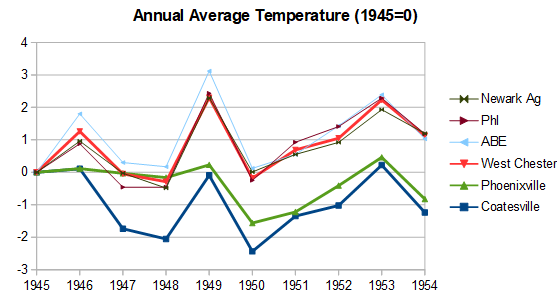
-
2025-2026 ENSO
donsutherland1 replied to 40/70 Benchmark's topic in Weather Forecasting and Discussion
My snowfall contingency tables for DCA, PHL, and NYC are AO-PNA tables. -
Looks like some folks in the western piedmont-triad are going to stay in the 60s today! That is unbelievable for early August. -20 degree daytime departures from average just Wow
-
 I was wrong relying on EPS for the OH Valley potential rainfall here. GEFS looks far superior for late this week, well in advance. My wrong. Now I worry about flash drought here in the Tri state, especially if we dont get late day convection. Wind ix not large but long days, high evapotranspiration and no rain are a concern imo, for. drought ion we cant get some decent rainfall in the next week or two.


