All Activity
- Past hour
-
I see that same weenie map every season. Worst of winter is right. 33 degrees and rain lol
-
Could you imagine
-
I'd love to see it! Would make for some fun comments.
-
Glad to have you on board!
-
Then this was in the forecast discussion this morning: AREA FORECAST DISCUSSION NATIONAL WEATHER SERVICE CHARLESTON SC 612 AM EDT MON AUG 11 2025 SYNOPSIS A STATIONARY FRONT TO THE SOUTH OF THE REGION SHOULD DISSIPATE TODAY. BY MID TO LATE WEEK, SURFACE HIGH PRESSURE WILL SHIFT INTO THE ATLANTIC, WHILE WEAK TROUGHING FORMS INLAND. NEAR TERM /THROUGH TONIGHT/ THE UPPER-LEVEL ANTICYCLONE THAT HAS BEEN POSITIONED WELL OFFSHORE OF THE SOUTHEAST U.S. FOR THE PAST SEVERAL DAYS WILL BEGIN TO BUILD WEST TODAY AND REPLACE THE MID-LEVEL WEAKNESS THAT HAS BEEN IN PLACE SINCE LAST FRIDAY. THE ATMOSPHERE WILL REMAIN MODESTLY UNSTABLE THROUGH THE AFTERNOON WITH A PLUME RICH, TROPICAL MOISTURE FEATURING PWATS HOLDING IN THE 2.30-2.65". SIMILAR TO THE PAST FEW DAYS, PASSING BITS OF VORTICITY PROPAGATING ALONG THE WESTERN PERIPHERY OF THE UPPER HIGH WILL BRING SEVERAL MORE BANDS/WAVES TO SHOWERS/TSTMS TO THE AREA. and THE HIGHEST RAIN TOTALS SINCE FRIDAY HAVE BEEN MOSTLY CONFINED TO THE COASTAL COUNTIES WHICH SHOULD CONTINUE AGAIN TODAY. ***SOME AREAS HAVE SEEN AS MUCH AS FOOT OF RAIN OVER THE PAST SEVERAL DAYS ALONE WHICH IS DOWNRIGHT INCREDIBLE FOR AUGUST OUTSIDE OF A TROPICAL CYCLONE.*** ————— I had been up to ~9.9” month to date through the period just before the rains returned at 11:30 PM last night. I don’t yet have my overnight total, but it was significant once again, quite possibly ~2”. I’ll update later.
-
Followup: It turned out that several bands of rain, sometimes moderate or heavy, continued to come in from the SE over this area. There was heavy near and soon after midnight. And then while I was sleeping, this occurred, still another FF warning for still another band of heavy:BULLETIN - EAS ACTIVATION REQUESTED FLASH FLOOD WARNING NATIONAL WEATHER SERVICE CHARLESTON SC 156 AM EDT MON AUG 11 2025 THE NATIONAL WEATHER SERVICE IN CHARLESTON HAS ISSUED A * FLASH FLOOD WARNING FOR... CHATHAM COUNTY IN SOUTHEASTERN GEORGIA... JASPER COUNTY IN SOUTHEASTERN SOUTH CAROLINA... * UNTIL 400 AM EDT. * AT 156 AM EDT, DOPPLER RADAR INDICATED AN LARGE BAND OF SHOWERS AND THUNDERSTORM WITH TORRENTIAL RAINFALL JUST OFF THE COAST OF CHATHAM COUNTY. THIS BAND WILL MOVE ACROSS MUCH CHATHAM COUNTY INTO PARTS OF JASPER COUNTY THROUGH 4 AM. THIS INCLUDES MUCH OF THE SAVANNAH METRO AREA. AS MUCH AS 1 TO 3 INCHES OF RAIN COULD FALL OVER A VERY SHORT PERIOD. THIS WILL RESULT IN URBAN FLOODING AND FLASH FLOODING. ROAD CLOSURES ARE POSSIBLE, ESPECIALLY ACROSS DOWNTOWN SAVANNAH. HAZARD...FLASH FLOODING CAUSED BY THUNDERSTORMS. SOURCE...RADAR INDICATED. IMPACT...FLASH FLOODING OF SMALL CREEKS AND STREAMS, URBAN AREAS, HIGHWAYS, STREETS AND UNDERPASSES AS WELL AS OTHER POOR DRAINAGE AND LOW-LYING AREAS. * SOME LOCATIONS THAT WILL EXPERIENCE FLASH FLOODING INCLUDE... POOLER, BLUFFTON, TYBEE ISLAND, MIDTOWN SAVANNAH, DOWNTOWN SAVANNAH, HUTCHINSON ISLAND, HUNTER ARMY AIRFIELD, WINDSOR FOREST, WILMINGTON ISLAND AND COFFEE BLUFF.————————Then this statement was issued:CHATHAM GA-JASPER SC- 326 AM EDT MON AUG 11 2025 ...FLASH FLOOD WARNING REMAINS IN EFFECT UNTIL 4 AM EDT EARLY THIS MORNING FOR CHATHAM AND JASPER COUNTIES... AT 326 AM EDT, DOPPLER RADAR INDICATED MODERATE TO LOCALLY HEAVY RAIN FALLING OVER MUCH OF CHATHAM COUNTY. WHILE THE MOST INTENSE RAIN HAS SHIFTED NORTH OF THE AREA, THE RISK FOR FLOODING CONTINUES. AS MUCH AS 1 TO 2.5 INCHES OF RAIN HAS FALLEN IN SOME AREAS SINCE 2 AM. HAZARD...FLASH FLOODING CAUSED BY THUNDERSTORMS. SOURCE...RADAR INDICATED. IMPACT...FLASH FLOODING OF SMALL CREEKS AND STREAMS, URBAN AREAS, HIGHWAYS, STREETS AND UNDERPASSES AS WELL AS OTHER POOR DRAINAGE AND LOW-LYING AREAS. SOME LOCATIONS THAT WILL EXPERIENCE FLASH FLOODING INCLUDE... POOLER, BLUFFTON, TYBEE ISLAND, MIDTOWN SAVANNAH, DOWNTOWN SAVANNAH, HUTCHINSON ISLAND, HUNTER ARMY AIRFIELD, WINDSOR FOREST, WILMINGTON ISLAND AND COFFEE BLUFF.
-
I’ve never seen a summer in W MA with so little thunder.
-
Well AVP has a shot at 90 tomorrow but probably end up 88-89
-
Gonna’ be a fast foliage season if it doesn’t rain.
-
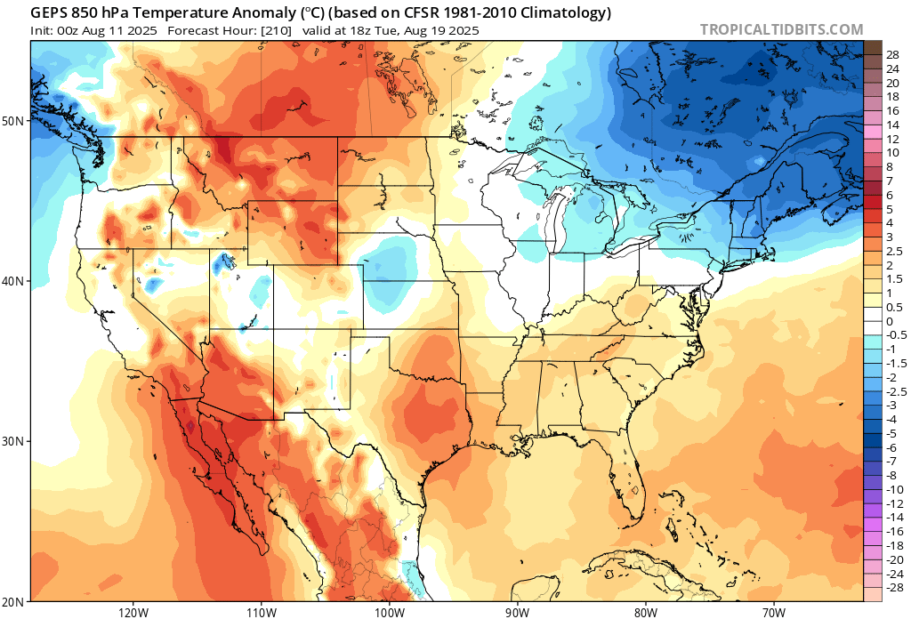
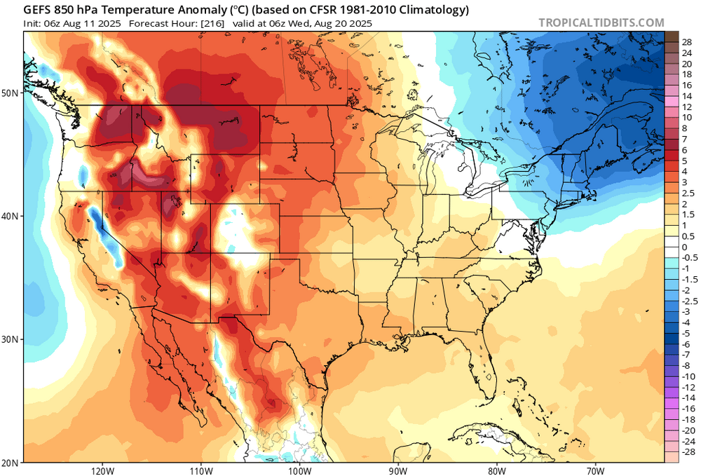
Mixing hgts are limited in these model runs, which is sort of shirking the heat potential some... I'm seeing like 925mb BL depths at 18z on the NAM. Standard adiabatic extrapolation can't get the 1000mb much past 30C if that's all. So... the 2-m are only 90..91. Yet, the 850 mb T's, the standard BL summer metric sigma height is up +18 or +19C, which if that were the adiabat we'd be talking 99 or 101. That's 10 F worth of shirk. Lol. The last heat of the season has the pedigree to be mid and upper 90s, yet the models are pancaking the mixing heights at max heating.
-
There is a very clear pattern that brings the storms up the coast to do damage. This is not even close to it. At worse it gets breezy conditions to Cape Cod maybe some showers at worst.
-
How many times have we heard this since the inception of American Wx?
-
It's like <1% chance, not worth spending time over.
-
Dude this is not the pattern. It’s over. Go catch a mid town shooter.
-
Days and days of 90*
-
Ahh the cute cold weenies. Good luck Breh. Enjoy the warming planet, it’s the only warming planet you got.
-
#ScooterKnows Innocent citizens of NYC now being dragged off the streets by an enraged patrolman [emoji23]
-
-
Its over at 200 hours? Since when we make definte statements this far out?
-
I wouldn't rule anything out of course at this phase. So much usually depends on how disorganized it stays (or the opposite). Certainly if it gets stronger quicker I'd favor the classic recurve. Those tracks at least leave a low probability door open for something to get closer than most of the tracks would indicate. If nothing else, seems like the Atlantic is stirring at a minimum.
-
6z Euro and bit west of 0z 6z EPS also a bit west through hr144. I get that chances are slim but you guys give up way to easy..
-
Hmm, yesterday 91* dp 54* HI 88. What a way to run a heat wave
-
To my fellow acatt crew. Summa almost done

-
 Erica? Isn’t the next named system Erin in the Atlantic.
 -
Dew…..dew hast…..dew hast ACATT….


.thumb.png.4150b06c63a21f61052e47a612bf1818.png)