All Activity
- Past hour
-

February 2026 Medium/ Long Range Discussion: Buckle Up!
GreyHat replied to Weather Will's topic in Mid Atlantic
It looked like the next couple systems get pushed OTS by the northern systems. Our area will be in the middle 30s Monday- Friday of next week before staying below freezing again. That's perfect our long range forecast. -

The “I bring the mojo” Jan 30-Feb 1 potential winter storm
BooneWX replied to lilj4425's topic in Southeastern States
When the euro and its machine brother are in agreement, look out. Jordan/Pippen combo. -
Atl folks got roped in. Hahahahahaha....they will absolutely be disappointed. Using the globals for snow totals. How did that work out last week? Desperate peeps.
-

The “I bring the mojo” Jan 30-Feb 1 potential winter storm
Buckfever2 replied to lilj4425's topic in Southeastern States
Anyway that ULL digs further west? Or at this point...is anything is possible. -

Possible coastal storm centered on Feb 1 2026.
WxWatcher007 replied to Typhoon Tip's topic in New England
So close yet so far -

February 2026 Medium/ Long Range Discussion: Buckle Up!
osfan24 replied to Weather Will's topic in Mid Atlantic
It’s relaxing this weekend and we swung and missed. -

Possible coastal storm centered on Feb 1 2026.
ORH_wxman replied to Typhoon Tip's topic in New England
You know this storm is in bad shape when he’s not posting. -

1-30/2-1-26 Arctic Blast, ULL Snow Event
Holston_River_Rambler replied to John1122's topic in Tennessee Valley
Oh yeah, I just saw the "High End" wording. You could have just let me believe for a few more minutes. -

Richmond Metro/Hampton Roads Area Discussion
jlewis1111 replied to RIC Airport's topic in Mid Atlantic
I think winter weather advisorys will replace Chesterfield and places west and north -

Possible coastal storm centered on Feb 1 2026.
Torch Tiger replied to Typhoon Tip's topic in New England
that QPF signature in the ocean laughing at us -
That is likely the 1/10 chance map.
-

Possible coastal storm centered on Feb 1 2026.
dendrite replied to Typhoon Tip's topic in New England
where’s ineedweenies with the eps members? I have my microscope ready -

February 2026 Medium/ Long Range Discussion: Buckle Up!
baltosquid replied to Weather Will's topic in Mid Atlantic
EPS and EPS-AIFS deepened the trough again. -

Richmond Metro/Hampton Roads Area Discussion
wasnow215 replied to RIC Airport's topic in Mid Atlantic
Gotta believe they'll be a warning south of the river now in the Midlo/Chesterfield area -

The “I bring the mojo” Jan 30-Feb 1 potential winter storm
scottk replied to lilj4425's topic in Southeastern States
Awesome, very helpful. Thanks. -
You’ll be back. We’ll all be back. There’s always another model run. Hopium will never be defeated
-

Possible coastal storm centered on Feb 1 2026.
40/70 Benchmark replied to Typhoon Tip's topic in New England
It contours the coast perfectly...just a vintage "FU" -
Both euro and gfs and their AI models have less than 1 in liquid equivalent through the end of their runs….there’s def some hints of possible storms 6-14 hopefully it pans out!
-
1-30/2-1-26 Arctic Blast, ULL Snow Event
Holston_River_Rambler replied to John1122's topic in Tennessee Valley
That WPC map is almost unbelievable.- 347 replies
-
- 1
-

-
- extreme cold
- snow
- (and 1 more)
-
Possible coastal storm centered on Feb 1 2026.
dendrite replied to Typhoon Tip's topic in New England
That will be your avg dewpoint all summer -
Possible coastal storm centered on Feb 1 2026.
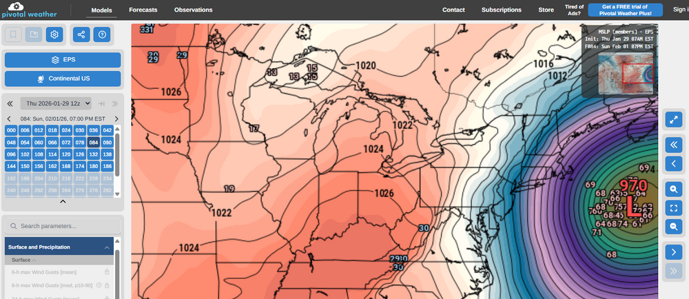
ORH_wxman replied to Typhoon Tip's topic in New England
EPS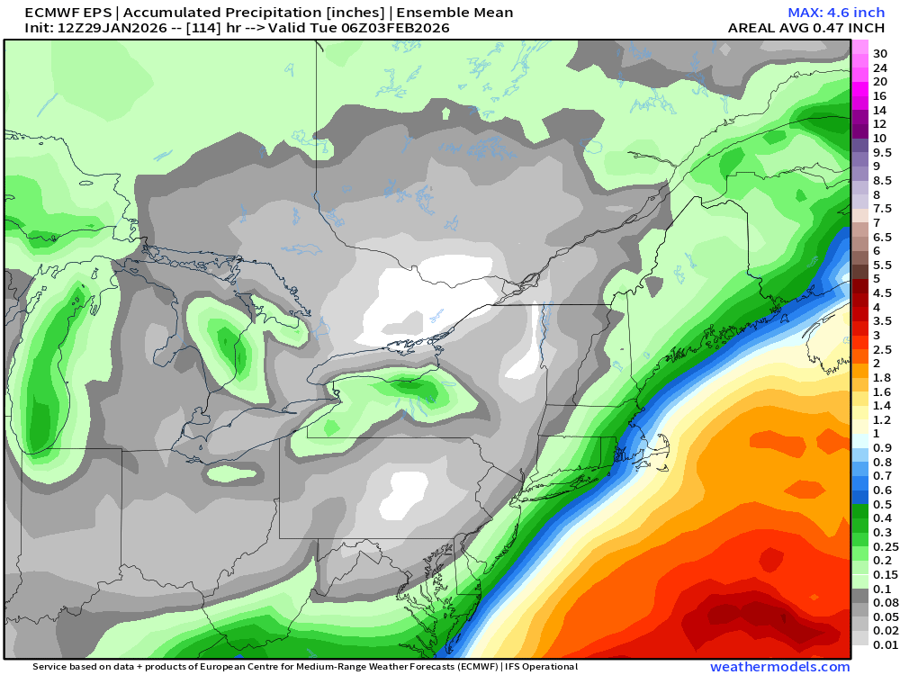
-
Richmond Metro/Hampton Roads Area Discussion
Shadowzone replied to RIC Airport's topic in Mid Atlantic
It will be interesting to see where warnings and advisories are posted. I'm on the northern edge in Mechanicsville, trying to advise our pastor about Sunday morning services. I sent her the AKQ briefing from this morning. We will chat again tomorrow afternoon after the 3:30 AKQ update. -
Possible coastal storm centered on Feb 1 2026.
dendrite replied to Typhoon Tip's topic in New England
Yeah let’s will that 969er into existence -
Possible coastal storm centered on Feb 1 2026.
40/70 Benchmark replied to Typhoon Tip's topic in New England
Yea, man, would make my day if I could ever get 69ed. -

Possible coastal storm centered on Feb 1 2026.
Wxbear25 replied to Typhoon Tip's topic in New England
would I lie to you about getting 69'ed?