All Activity
- Past hour
-
Edibles
-
it's amazing how this winter hasn't yet really ended specifically for this discrete region of the planet. heh
-
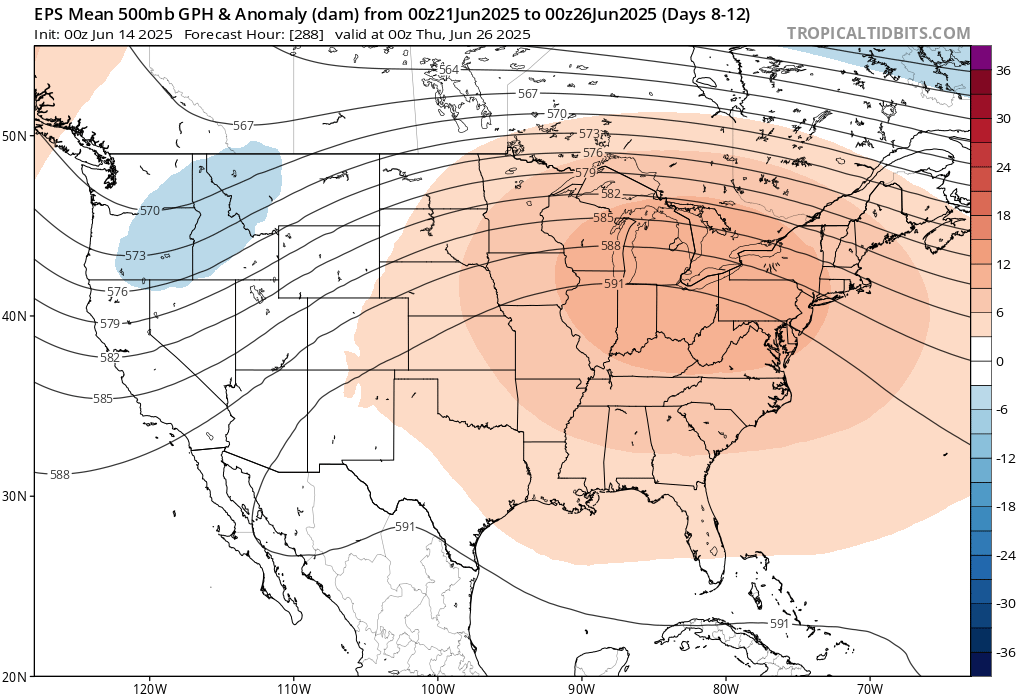
yup ... euro even manifests a nice mcs signal. only 180 hour out there but who's county. this appears to be on the nose of a 576 to 582 dm SW/W heat release in that run btw
-
It’s a shat day whether it’s 0.05” or 0.50”. BTV FTW today
-

2025-2026 ENSO
Stormchaserchuck1 replied to 40/70 Benchmark's topic in Weather Forecasting and Discussion
I might not get out of the 60s Sunday and Monday. June is usually a big seasonal transition. I can't remember a time after my birthday (early June) where that has happened before (not getting out of the 60s). -
The HREF looked pretty dry as well for several runs in a row. .10 to .20 for New England.
-
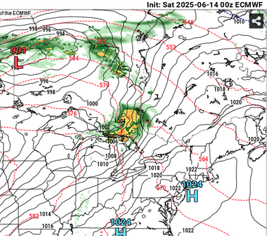
Area Forecast Discussion National Weather Service Baltimore MD/Washington DC 1011 AM EDT Sat Jun 14 2025 .SYNOPSIS... A stalled frontal boundary will continue to oscillate over the region through the weekend bringing increased chances for showers and thunderstorms. Thunderstorm activity will be tied to the afternoon and evening hours with flash flooding and locally damaging winds as the primary threats. The front lifts north as a warm front Tuesday into Wednesday with a strong cold front expected to cross late next week. Temperatures will remain at or above average through the period. && .NEAR TERM /THROUGH TONIGHT/... A stationary front is currently positioned over the northern DC metro. This boundary will become the focus for the development of heavy showers and thunderstorms late this afternoon and into this evening. Based on morning HiRes guidance, we have expanded the Flood Watch for flash flooding to the NE to include parts of the Baltimore metro along with parts of northern MD and eastern panhandle of WV. The environment this afternoon and into afternoon will be favorable for efficient rainfall with PW`s approaching 2 inches this afternoon and saturated through much atmospheric column. This environment will be favorable for hourly rain rates between 2 to 4 inches being possible with instantaneous rain rates approaching 6 inches per hour possible.
-
53.9° and overcast at 11am. It’s not raining so I guess we’ll go 2/10.
-
Thanks for the kind words. Are you still up in the Frederick area?
-
I've been working outside all morning. Just a few showers here. BDR T DXR T HVN .01 GON .01
-
A link to the data please
-
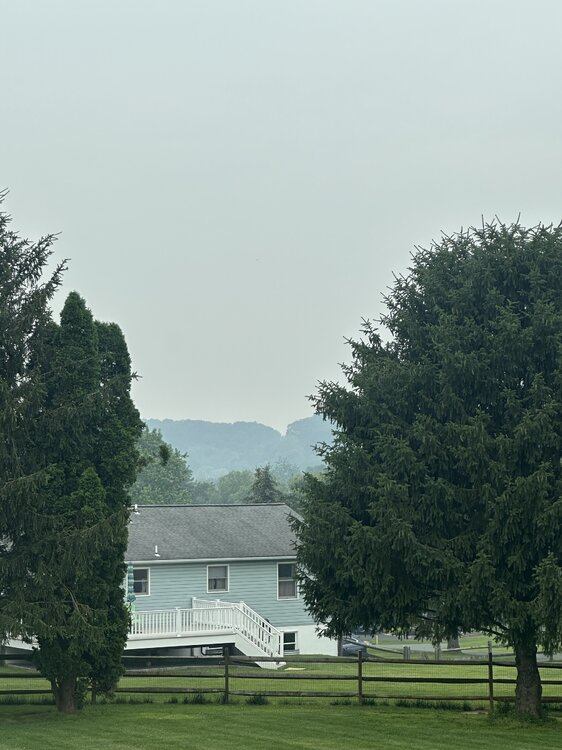
Yeah, visibility is shit here too. Smells terrible. It rained earlier and left splotches of ash on my car
-
Summer Solstice. My summer starts June first.
-
Didn’t someone say 6z Euro qpf was usually right the day before?
-
Yep, huge differences here. Some of the area got 1/3-1/2 inch (0.34 here), then a stripe from far western Alleghany up into southern Bath county got like 2-3 inches. Pushed Dunlap creek up 2-2.5 feet and Jackson river up a foot or so (and muddy) with rest of creeks and rivers in area barely moving.
-
Up to 59° and the rain is mostly light. All in all pretty nice day.
-
Same here, low visibility all things considered and a strong smell of smoke. Weekends have had clouds and rain here 11 out of 15 , now add nasty smoke particulates.
-
It’s bad up here.
-
1953 had a historically hot summer for us too, with two legendary historic heatwaves with 4 100+ degree days spread evenly between them and even a historic severe wx outbreak with an F4 tornado in Worcester, MA!! 1953: The warmest June on record occurred in Oklahoma City, OK. The main part of the heat wave extended from the 11th through the 21st, and seven of the daily high temperatures during that stretch remain records for their respective dates. June 14th was the hottest day, reaching a toasty 106°. The other records ranged from 100° to 105°. Even the nighttime lows were records. Eight daily minimum temperatures from June 1953 are still record-warm daily minimum temperatures, ranging from 75° to 80°. (Ref. Wilson Wx. History)
-
days and days of suffering

-
Thursday could be even hotter than this past Thursday was! Friday is the first day of summer.
-
July 2011 had historic heat. About July 2013 that was one hot month, I remember July 4th was very stuffy, big heat and no wind lol. That was the last time PHL hit 100 too wasn't it?
-
historic heat that summer too!!
-

2025-2026 ENSO
PhiEaglesfan712 replied to 40/70 Benchmark's topic in Weather Forecasting and Discussion
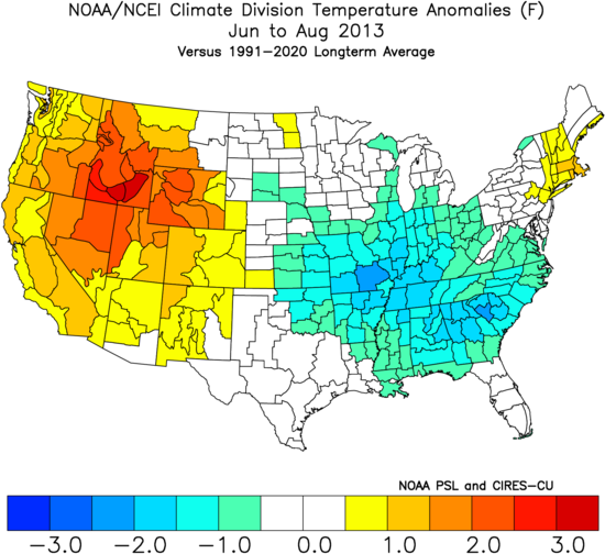
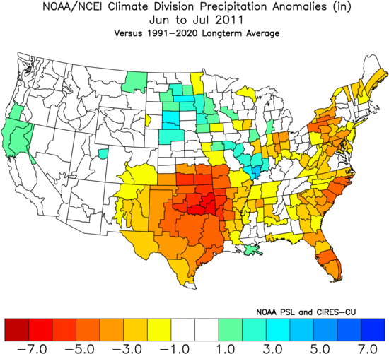
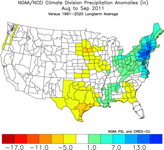
2013 was a frontloaded summer at best. That one was pretty much done by 7/21. It's the only August without a 90+ day here in PHL in the last 40 years. Outside of that super heat wave in July, 2013's summer temperature stats were nearly identical to 2014 (with June and August both years differing by 0.1 2010-2012 had widespread heat in the East: I don't see that with 2013 (which in fact looks cool in the Southeast): Of course, that was a much stronger la nina. The first year was a strong la nina, and the second a moderate la nina. Not to mention, a deepening -PDO and a pattern that changed at the start of November. Everything that could go wrong, went wrong, which is why we had the torch we had from November 2011-March 2012. (I don't see any similarities with now. In fact, I see much more similarities with 2013 than with 2011. Like now, we are much closer to ENSO neutral and a solar max in 2013. Definitely not what we had in 2011.) 2011 was dry in June and July. The record rains were in August and September.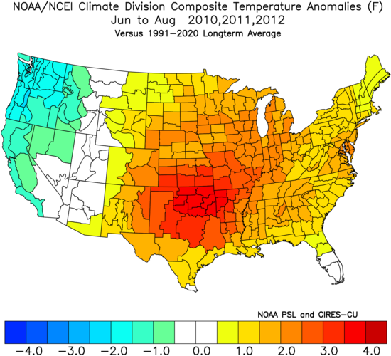
-
Stein finally came.