All Activity
- Past hour
-
-

Jan 30th-February 1st 2026 Arctic Blast/ULL Snow OBS Thread.
housemtnTN replied to John1122's topic in Tennessee Valley
I think I'm about to have goose feathers. This is wild. Visibility is probably less than 1/10 mile, just absolutely puking it all out! -

The “I bring the mojo” Jan 30-Feb 1 potential winter storm
Silver Meteor replied to lilj4425's topic in Southeastern States
The weak Low moving near the S.C. you refer to has since stretched out and is now in the process of reforming notably farther offshore, probably where it was supposed to form. Notice the tropical feed here at 2:30am. https://www.ventusky.com/wind-speed-map/10m-above-ground#p=31.8;-76.5;5&w=0xIAb9A9A -

Arctic Hounds Unleashed: Long Duration Late January Cold Snap
Ginx snewx replied to WxWatcher007's topic in New England
Thaw?.thumb.png.773bc9082f5ed8d3f6940d0609ff847a.png)
-

Jan 30th-February 1st 2026 Arctic Blast/ULL Snow OBS Thread.
ShawnEastTN replied to John1122's topic in Tennessee Valley
Yeah I've been getting quarters mixed with smaller flakes. Then an occasional wind gust blows clouds of blowing snow off my roof and it swirls around. I'm at about 2 inches now which was the high end of my MRX forecast. -

Jan 30th-February 1st 2026 Arctic Blast/ULL Snow OBS Thread.
John1122 replied to John1122's topic in Tennessee Valley
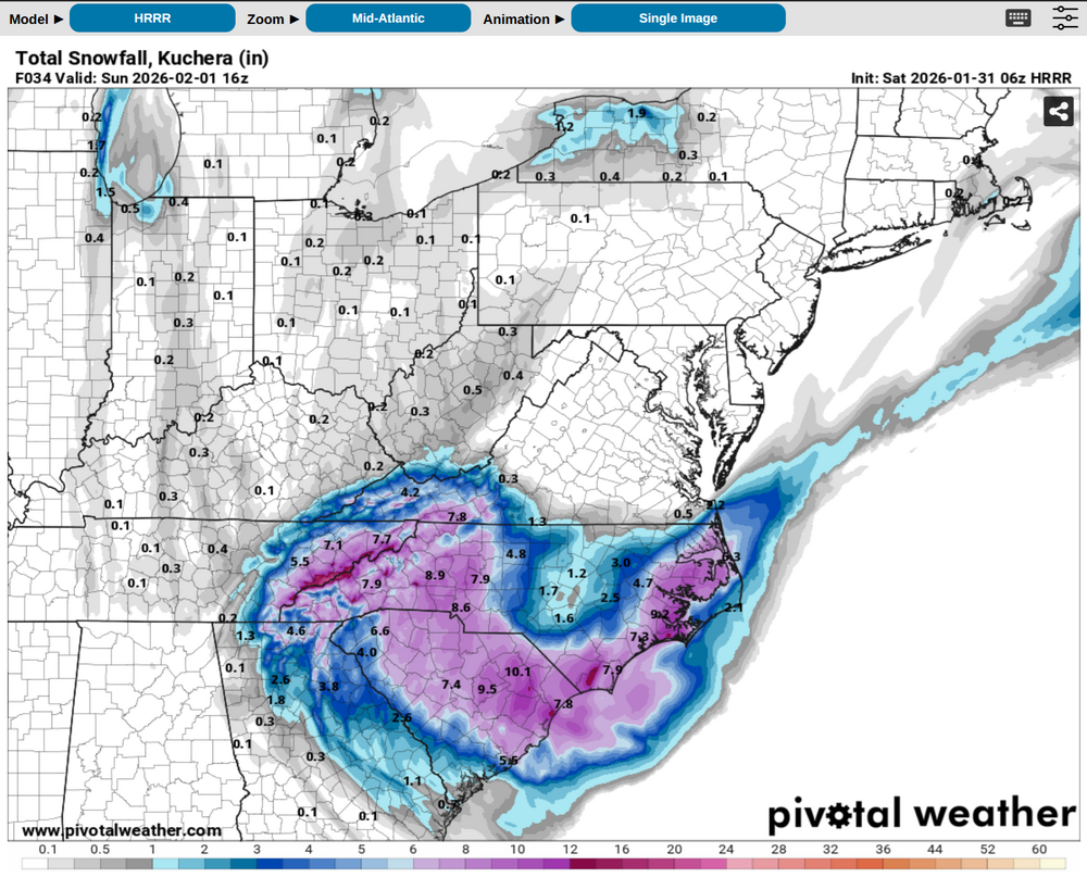
I think the 10+ projections from models that way will probably verify. The ratios are incredible so it will really stack up. I can't account for micro climates there because I don't know them like the folks who live there. But I did see that this was overperforming around Bristol at least. And Tri had 5 inches 2 hours ago. -

2025-2026 Fall/Winter Mountain Thread
Rainforrest replied to Buckethead's topic in Southeastern States
Little over 2” still moderate snow. -

Jan 30th-February 1st 2026 Arctic Blast/ULL Snow OBS Thread.
Hurricaneguy replied to John1122's topic in Tennessee Valley
John based on what has fallen and what could still yet to fall taking into count hi res models duration left, what do you think areas around Greeneville through Johnson City end up with? -
Jan 30th-February 1st 2026 Arctic Blast/ULL Snow OBS Thread.
John1122 replied to John1122's topic in Tennessee Valley
That's when I started really accumulating fairly quickly. It got up to about 3/4ths inch to 1 inch per hour for a few hours. -
That's because you have fluff. Mine is meat. 18 16 16 16 16 16. NWS depth BDL 16 15 15 15 15 15 So there's that
-
Jan 30th-February 1st 2026 Arctic Blast/ULL Snow OBS Thread.
John1122 replied to John1122's topic in Tennessee Valley
Looks like Hamilton is getting in on the action now. -

Jan 30th-February 1st 2026 Arctic Blast/ULL Snow OBS Thread.
Stovepipe replied to John1122's topic in Tennessee Valley
I did not expect huge chunky flakes with this system... but I'm over here watching quarters pile up. It's a beauty. 20.7 degrees. -
Jan 30th-February 1st 2026 Arctic Blast/ULL Snow OBS Thread.
John1122 replied to John1122's topic in Tennessee Valley
Looks like the radar is about to light up over TellicoWx soon. It's quickly filling Blount County and extending down into Monroe County now. I see that the Tri-Cities has 5+ already and Tys over 2. Hopefully our NE Tn crew us doing well. I hope Holston's snow hole wasn't a thing either. -

Richmond Metro/Hampton Roads Area Discussion
eaglesin2011 replied to RIC Airport's topic in Mid Atlantic
The models are all over the place because they could not decide how & where the transfer from the upper low to the coastal would be.. That combined with some of the models struggling with how much the dry air already in place would also affect this storm is why the models have been all over the place… Dude just can’t ever fully admit that he saw it wrong himself.. -

Possible coastal storm centered on Feb 1 2026.
Abbyme24 replied to Typhoon Tip's topic in New England
It sure is beautiful up here, can’t wait to explore the Cabot Trail ourselves and cape Breton in general. We moved for my wife’s job, here on a couple year work permit but hoping to make it permanent. The snow weenie in me is thrilled at that possibility -
Welcome to the jungle. Location?
-

Jan 30th-February 1st 2026 Arctic Blast/ULL Snow OBS Thread.
Reb replied to John1122's topic in Tennessee Valley
It seems to only be picking up the heavier bands -

Jan 30th-February 1st 2026 Arctic Blast/ULL Snow OBS Thread.
Jeff Co Vol replied to John1122's topic in Tennessee Valley

-

February 2026 Medium/ Long Range Discussion: Buckle Up!
TowsonWeather replied to Weather Will's topic in Mid Atlantic
Atlanta getting 3 feet is 100% realistic, though. -
I call this… “pornografique es snow” .
-
Jan 30th-February 1st 2026 Arctic Blast/ULL Snow OBS Thread.
John1122 replied to John1122's topic in Tennessee Valley
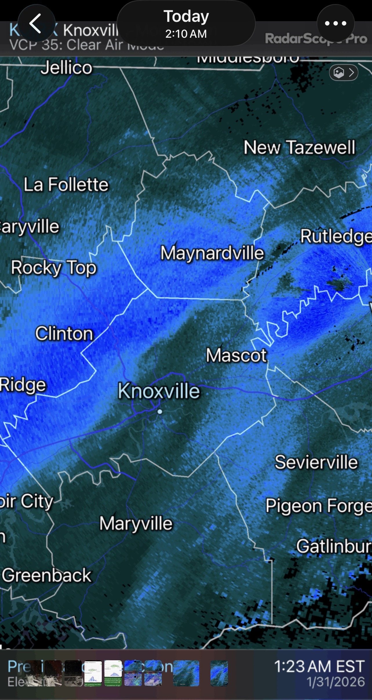
This isn't quite developing the way the HRRR seems to think it should, which was down the Apps and expanding NW, but a big shield is developing over the Plateau and its heading towards the valley. The radar does look like it's itching to explode down the 75 corridor to the mountains of SE TN. -
Jan 30th-February 1st 2026 Arctic Blast/ULL Snow OBS Thread.
housemtnTN replied to John1122's topic in Tennessee Valley
Ripping out my way. Visibility has gotta be less than 1/4 mile. -
Jan 30th-February 1st 2026 Arctic Blast/ULL Snow OBS Thread.
John1122 replied to John1122's topic in Tennessee Valley
5.5 inches, tiny flakes but very thick and foggy looking, its 15 degrees. -

Jan 30th-February 1st 2026 Arctic Blast/ULL Snow OBS Thread.
Wurbus replied to John1122's topic in Tennessee Valley
I've got to get some sleep, but man its ripping out there! -
3 inches with moderate snow. This stuff is just beautiful with fatties coming down.


.png.73456314a68ad5aeb3f29e02d28dbc33.png)