All Activity
- Past hour
-

Saturday 9/6 Strong/Severe storm potential
Torch Tiger replied to Torch Tiger's topic in New England
womp womp
-
Said this yesterday. The plug has been pulled.
-
We haven’t turned ours on yet, the house has been staying around 65-67 with the windows closed and lows in the mid 40s down here. Natural gas fireplace has been flipped on though.
-
39 here this morning again.
-
ECM is now incapable of seeing below normal temps. It blowtorches everything >30 days out by default now. Garbage warm biased model
-
We moved to Fort Kent on Jan 1, 1976 and moved back south (Gardiner) on Oct 25, 1985, so I missed the big Novie dump, though we waded thru it a week later on Public Land (Scraggly Lake) just NE from Baxter Park. The day we moved to FK was relatively mild, low 20s. Then Jan 9-13 had minima -33/-36/-24/-41/-37. 1976 was probably the most weather-eventful year of my lifetime, though the 12 months March 1960-Feb 1961 was close.
-
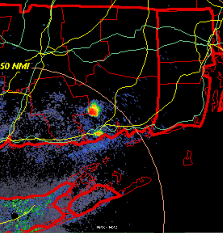
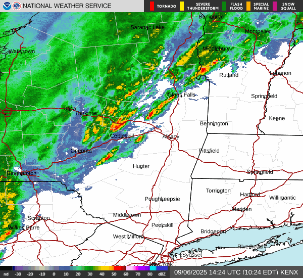
What’s up with all the radar returns going on right now? I know birds and other animals can cause reflections but I’ve never seen widespread yellow reflections from that.
-
Mother Nature "F.U. and your garage sale preparations." What happened to this forecast? "Today Showers and thunderstorms likely, mainly after 5pm. Mostly sunny, with a high near 83. South wind 10 to 14 mph."
-

2025-2026 ENSO
40/70 Benchmark replied to 40/70 Benchmark's topic in Weather Forecasting and Discussion
It still got the pattern wrong, though...which is why it was too warm. I wouldn't consider it a win for those that forecasted a big winter for the mid atlantic during the 2015-2016 season, despite the fact that snowfall worked out. I'm not arguing your point about storm track, but the EURO seasonal was still a tremendously flawed forecast. I am willing to bet if we had less of a neg NAO last season, the northeast would have done better via more overrunning and SWFE snowfall, kind of like what we saw in February. I understand your point about increased reliance on Benchmark tracks in the NE, but some of that is due to SE Canada being warmer relative to other areas independent of CC. We saw that shift some last year and if se Canada is appreciably cold again, which I suspect that it will be, I would bet on more snowfall. -
Wow this is winter levels of falling off a cliff…
-
The 12z NAM just jacked up totals. Now a stripe of 2” through CNE to SE NH
-
Saturday 9/6 Strong/Severe storm potential
Torch Tiger replied to Torch Tiger's topic in New England
Great day to go for a drive even if the storms aren't particularly good. -
Just get TBlizz to start b*tching and you’ll get drenched.
-

September 2025 OBS-Discussion centered NYC subforum
wdrag replied to wdrag's topic in New York City Metro
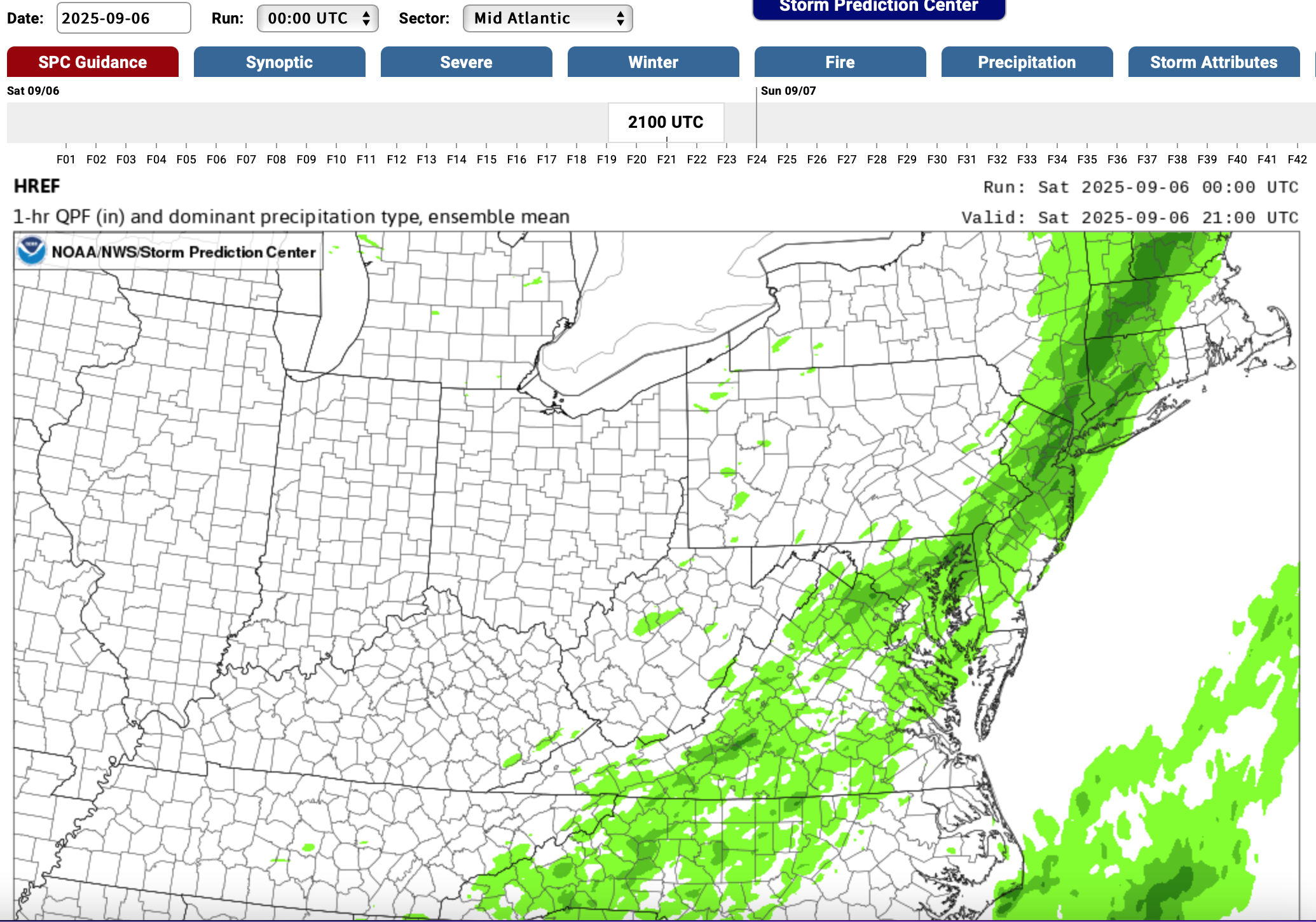
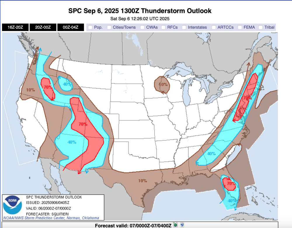
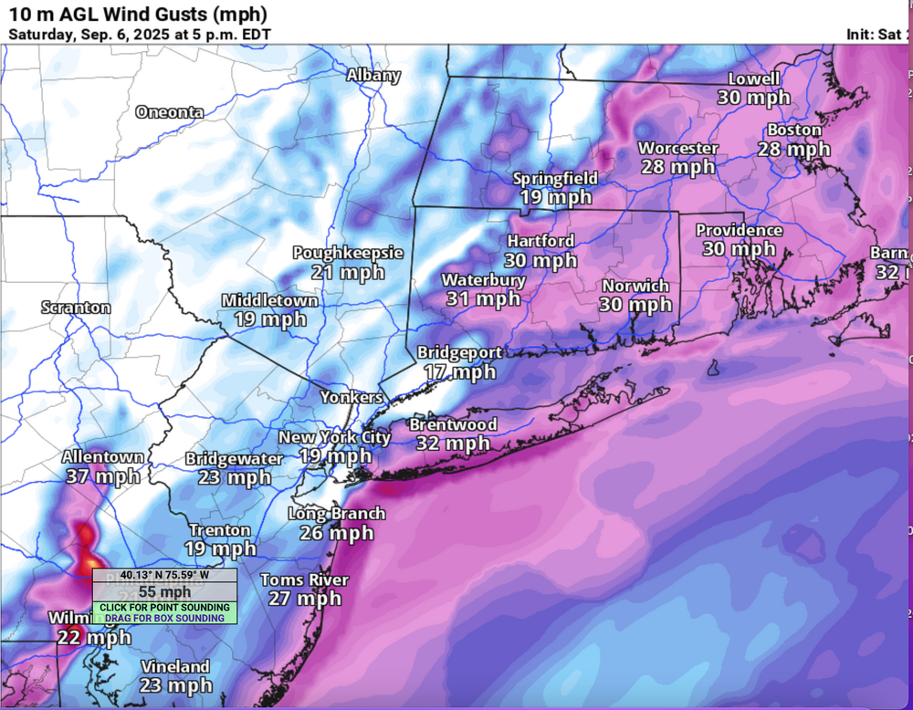
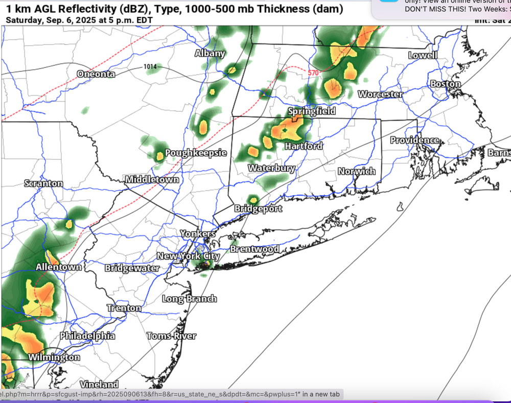
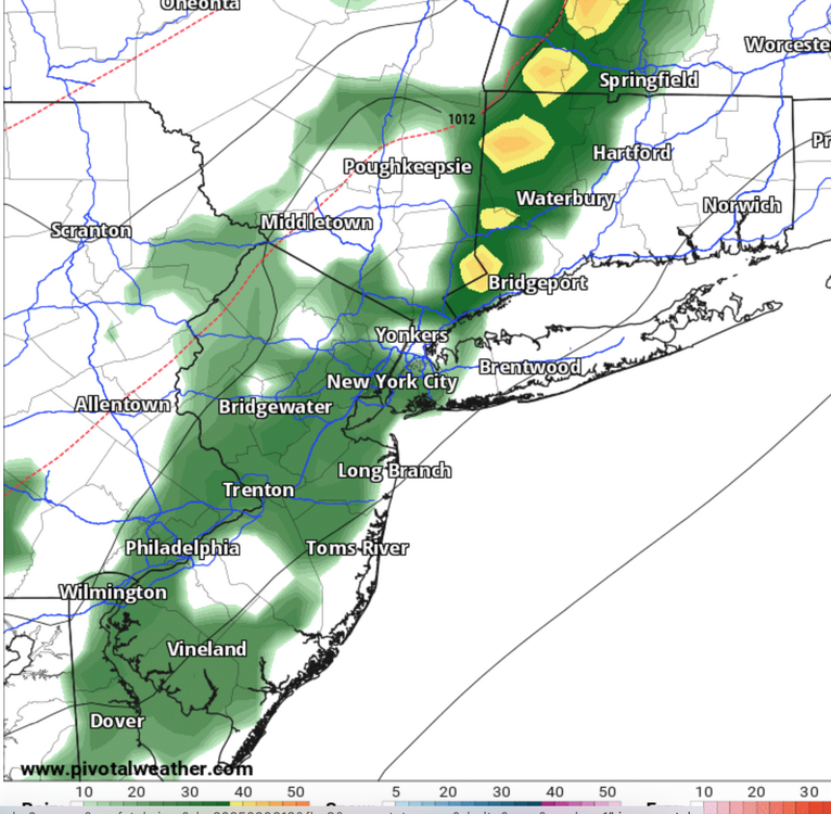
Regarding this afternoon I95 corridor: Not knowing when football games start etc... but be prepared for delays. Regarding Philly... your call as always. I would not risk outdoor celebration if it was me, except maybe the initial ceremony. NO guarantees as to what will happen but here is info from SPC and late arriving HRRR. Watch for convection NYC area developing 1230-2P, then the big squall line forming 2PM e PA and marching e from there. See graphics... cherry picked indeed but stuff I use to make decisions. I may still get a NOW thread going at 130PM. I do think there are going to be travel delays due to ponding on roads and 1-2.5" in spots by 8PM. PWAT pretty high... near 1.8". Graphics imply be alert... there will be variations. Consider downside risk outside your personal interest and thinking of impact on surroundings. Last night SPC HREF hourly for 5P. The SPC outlook prob for thunderstorms 4-8P (70% I95 corridor 13z HRRR gust graphic 5P (55 MPH se PA) 13z HRRR 5P reflectivity (might be too slow) 12z NAM 5P.
-
Hey, don't mean to "interrupt," but I just moved to Northampton, Mass. from Brattleboro, Vermont. I am from Boston proper, the city, not the burbs, although I went to Newton North High School. We have some weather coming here: Special Weather Statement National Weather Service Boston/Norton MA 419 AM EDT Sat Sep 6 2025 ...SCATTERED SEVERE THUNDERSTORMS THIS AFTERNOON... A cold front brings potential for scattered severe thunderstorms today to interior southern New England. Thunderstorms may begin to pop-up across eastern New York, along the border with Connecticut and Massachusetts early as 12-2pm. There after is prime time for storms to build develop,between 2-6pm, across the interior of southern New England. Expect thunderstorms to weaken as the line shifts to the I-95 corridor between 7-10pm. Thunderstorms will have the potential to produce straight-line damaging winds, hail, localized flash flooding in urban areas or locations of poor drainage, frequent lightning, and a lower risk of tornadoes. Whether you are heading to an outdoor event or hanging around the house, today is one of those days to remain weather aware, and have multiple ways of receiving weather alerts (cell phone notifications, NOAA Weather Radio, and broadcast meteorologists). $$ Dooley
-
2025-2026 ENSO
40/70 Benchmark replied to 40/70 Benchmark's topic in Weather Forecasting and Discussion
Did NOT get the pattern right, though.....suprised someone as meticulous as you would omit that. -
Sun breaking out here.
-
There is going to be a screwgie zone somewhere between me and Tblizz. well modeled but placement tbd, as I'm sure it will be somewhat scattershot on Sunday. Stein will do his best . better chance of avoiding it further down cape
-
Since you mentioned MJO, you made me look! Lol Looks like all modeling has recently (day?) shifted back away from 4-5-6. https://www.stormsurf.com/page2/links/mjo_phase.html
-
2025-2026 ENSO
40/70 Benchmark replied to 40/70 Benchmark's topic in Weather Forecasting and Discussion
Yes, this is what I have always said about climate models...they are biased towards stock ENSO. -

September 2025 OBS-Discussion centered NYC subforum
winterwarlock replied to wdrag's topic in New York City Metro
my concern focuses on the rutgers game which has a 330 kickoff.....looking like its probably rain free until at least 6 according to the hrrr, the nam looks spotty with an earlier start -
September 2025 OBS-Discussion centered NYC subforum
wdrag replied to wdrag's topic in New York City Metro
Alright... I'll post some info for all to digest in 3 min. -
2025-2026 ENSO
40/70 Benchmark replied to 40/70 Benchmark's topic in Weather Forecasting and Discussion
I thought mine from last year was okay...not great, but not bad. -
September 2025 OBS-Discussion centered NYC subforum
winterwarlock replied to wdrag's topic in New York City Metro
i am specifically talking about the 2-7 pm timeframe not the whole event map -
Huge fail here snowfall wise in the southern apps. Had about average snow here, 43 inches.